- Holston River
-
For other uses of "Holston", see Holston (disambiguation).
Holston River 
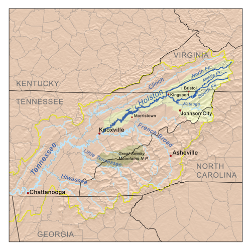
The North Fork of the Holston River near Weber City, Virginia.Origin Bland County, Virginia Mouth Tennessee River at Knoxville Basin countries USA Length 274 miles (441 km) to farthest source - the North Fork[1] Source elevation 816 feet (249 m) Avg. discharge 4,848 cubic feet per second (137.3 m3/s) Basin area 3,747 square miles (9,700 km2) 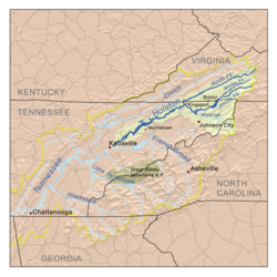 The Holston drainage basin, located within the upper Tennessee drainage basin
The Holston River is a major river system of southwestern Virginia and east Tennessee. The three major forks of the Holston (its North, Middle and South Forks) rise in southwestern Virginia and have their confluence near Kingsport, Tennessee. The North Fork flows 138 miles (222 km) southwest from Sharon Springs in Bland County, Virginia. The Middle Fork flows 56.5 miles (90.9 km) from near the western border of Wythe County, Virginia, joining the South Fork in Washington County southeast of Abingdon. The South Fork rises near Sugar Grove in Wythe County and flows 112 miles (180 km) southwest to join the North Fork at Kingsport. From there the main stem of the Holston River flows 136 miles (219 km) roughly southwestward, just north of Bays Mountain, until it reaches its confluence with the French Broad River just east of downtown Knoxville, Tennessee.[1] This confluence is considered to be the start of the Tennessee River.
The Holston River valley is greatly developed for electrical power generation, both with hydroelectric dams and coal-fired steam plants. In its upper reaches some of these plants are controlled by private interests; in the downstream portion they are owned by the United States Government's Tennessee Valley Authority. Among the dams and associated reservoirs on the South Fork Holston River are Boone Dam and Boone Reservoir; Fort Patrick Henry Dam and Fort Patrick Henry Reservoir, and South Holston Dam and South Holston Reservoir. Cherokee Dam on the Holston River forms Cherokee Reservoir.
The river was named after Stephen Holstein, who built a cabin on the upper reaches of the river in 1746.[2] Holston Mountain was named after the Holston River.
Although the Holston River is now defined as ending at the French Broad River to form the Tennessee River at its mile post 652 in Knoxville, before 1933 the terminus of the Holston River was defined as the location 51 miles (82 km) downstream of Knoxville at Lenoir City where the Little Tennessee River enters the river. That point, the confluence of the Holston and Little Tennessee rivers, was considered to be the beginning of the Tennessee River, 601 miles (967 km) upstream from the Ohio River at Paducah, Kentucky. According to Tennessee Valley Authority historians, when the Tennessee Valley Authority was created in 1933, Congress mandated that the TVA headquarters be located on the banks of the Tennessee River. Since the TVA headquarters were to be located in downtown Knoxville on what was then the Holston River, in order to fulfill the Congressional mandate the official start of the Tennessee River was moved upstream from Lenoir City to the confluence of the Holston and French Broad rivers.
All three forks in Virginia, South Holston Lake, and the Holston River in Tennessee below the South Holston Dam offer relatively easy-to-reach recreation opportunities. The North Fork in Virginia is known[citation needed] as an excellent smallmouth bass river (due to mercury contamination, fish caught in the North Fork of the Holston below Saltville, Virginia should not be consumed), and both the South Fork in Virginia and the first 20 miles (32 km) of the Holston in Tennessee below South Holston Dam are quality brown trout and rainbow trout fisheries, with the latter wide and open enough to allow extensive fly fishing to take place. South Holston Lake offers a variety of fishing opportunity as well, containing smallmouth bass, common carp, walleye, pike, sunfish, crappie and a few trout.
See also
- List of Tennessee rivers
- List of Virginia rivers
- Watauga River
- Doe River
References
- ^ a b "The National Map". U.S. Geological Survey. http://viewer.nationalmap.gov/viewer/. Retrieved Feb. 16, 2011.
- ^ Stewart, George R. (1967) [1945]. Names on the Land: A Historical Account of Place-Naming in the United States (Sentry edition (3rd) ed.). Houghton Mifflin.
External links
Categories:- Rivers of Tennessee
- Rivers of Virginia
- Tennessee River
- Rivers on the Appalachian Trail
- Geography of Bland County, Virginia
- Geography of Wythe County, Virginia
- Geography of Grainger County, Tennessee
- Geography of Washington County, Tennessee
- Geography of Knox County, Tennessee
- Geography of Sullivan County, Tennessee

Wikimedia Foundation. 2010.