- Downtown Spokane
-
Downtown Spokane is the central business district in Spokane, Washington. Downtown Spokane's rough boundaries are I-90 to the south, Division St. to the east, Maple St. to the west, and the Spokane River to the north, though the north bank of the river is essentially part of downtown, with bridges or pedestrian only bridges spanning the river at nearly every block.
Contents
Buildings
 The Hotel Carlyle
The Bank of America Financial Center, standing at 288 feet (88 m) tall, is the tallest building in Spokane. It was completed in 1981. The nearby Wells Fargo Center is the second tallest building (243 ft), and was completed in one year later 1982. Until 2006, with the construction of the Davenport Tower & Residences (an expansion of The Davenport Hotel), no other high-rise has gone up in Spokane.
Other significant buildings in downtown include the Spokane Convention Center, the INB Performing Arts Center, and the Spokane Arena.
Geography
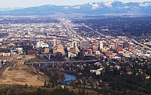
 Downtown from the West
The topography of Downtown Spokane is mostly flat except for areas downstream of the Spokane Falls which are located in a canyon. South of downtown slopes up to the South Hill, quite steeply in some places such as Pioneer Park, where long cliffs oriented east-west provide great views of the downtown, the North Side and Spokane Valley to the east. Downtown straddles Sprague Avenue which divides the city into North and South. On the eastern end of Downtown Division Street splits the city into East and West. I-90 is elevated thru almost all of downtown, often with parking lots underneath but occasional blocks are solid cement, forming a barrier at the southern end of Downtown. Immediately south of the interstate the high density area continues into a growing medical district with Spokane's two largest hospitals, Sacred Heart and Deaconess. To the west one is one of Spokane's oldest neighborhoods and densest neighborhoods, Browne's Addition. In the photo, Browne's addition is the treed area in the foreground on the right. The left side of the foreground is the valley cut by the Spokane river immediately downstream of the falls, this area is the small and similar neighborhood of Peaceful Valley. Gonzaga University is located just upstream on the north side of the river from Downtown. Across the river from Gonzaga is the new University District home campuses of Eastern Washington University and Washington State University, Division street separates Downtown from the University District.
Downtown rebirth and development
 Lobby of the Davenport Hotel
Downtown Spokane had undergone a major rebirth in the years before the recession, after the completion the River Park Square Mall.[1] The historic Davenport Hotel underwent a major renovation in 2002 after being vacant for over 20 years.[2] The project was funded by local entrepreneur Walt Worthy, who also added a Safari-themed 20 story tower to the hotel in 2007. Other major projects include the Holley Mason Building - seen as the catalyst to downtown Spokane's rebirth, the building of the Big Easy concert house (now renamed the Knitting Factory), the remodeling of the historic Montvale Hotel and Fox Theater (now home to the Spokane Symphony), numerous new condo buildings, and renovations of historic, older brick buildings that will soon house both condos and business. Also, the Spokane Convention Center just finished a major expansion which helped host the 2007 US Figure Skating Championships.[3] All new skyscrapers built in Spokane are subject to city height restrictions, and therefore, any new efforts to build major buildings are hampered. Recently, a local developer (Rob Brewster) has proposed building the new VOX Tower which, if approved, will become the tallest building in Spokane.[4]
Kendall Yards
The new Kendall Yards development on the northside of Downtown Spokane along the Spokane River will become one of the largest construction projects in the city's history. The proposed development will directly connect to downtown with bridges across the Spokane River and will blend residential and retail space with plazas, and walking trails. Phase I of the development will incorporate about 300 residential units and 450,000 square feet (40,000 m2) of non-residential use. Town homes, condominiums, and apartments will comprise the residential makeup.[5] Upon completion, the nearly 80-acre (0.32 km2) Kendall Yards project will include up to 1,100 residential units and up to 600,000 square feet (56,000 m2) of commercial, retail, and office space.[5]
Parks
 The Great Northern clock tower and U.S. Pavilion in Riverfront Park
Riverfront Park, created after Expo '74 and occupying the same site, is 100 acres (0.40 km2) in downtown Spokane and the site of some of Spokane's largest events.[6] The park has views of the Spokane Falls, and holds a number of civic attractions, including a Skyride that is a rebuilt gondola that carries visitors across the falls from high above the river gorge, a 5-story IMAX theater, and a small amusement park (which is converted into an ice-skating rink during the winter months) with numerous rides and concessions.[6] The park is host to a full schedule of family entertainment and events such as the Bloomsday Post-Race Celebration, Hoopfest, the IMAX Film Festival, Spokane Music Festival, Pig-Out in the Park, Restaurant Fair, Pow Wow, First Night Spokane, plus many outdoor concerts and other community activities. The Park also includes a hand-carved carousel created in 1909 by Charles I. D. Looff as a wedding present for his daughter.[7] The carousel still operates in Riverfront Park, where riders can participate in an old-time ring toss. The carousel continues to offer a free ride to the rider who grabs the brass ring. Riverfront Park also includes ample views of the Spokane falls as well as other water features (some man-made) of the Spokane River.
Cityscape
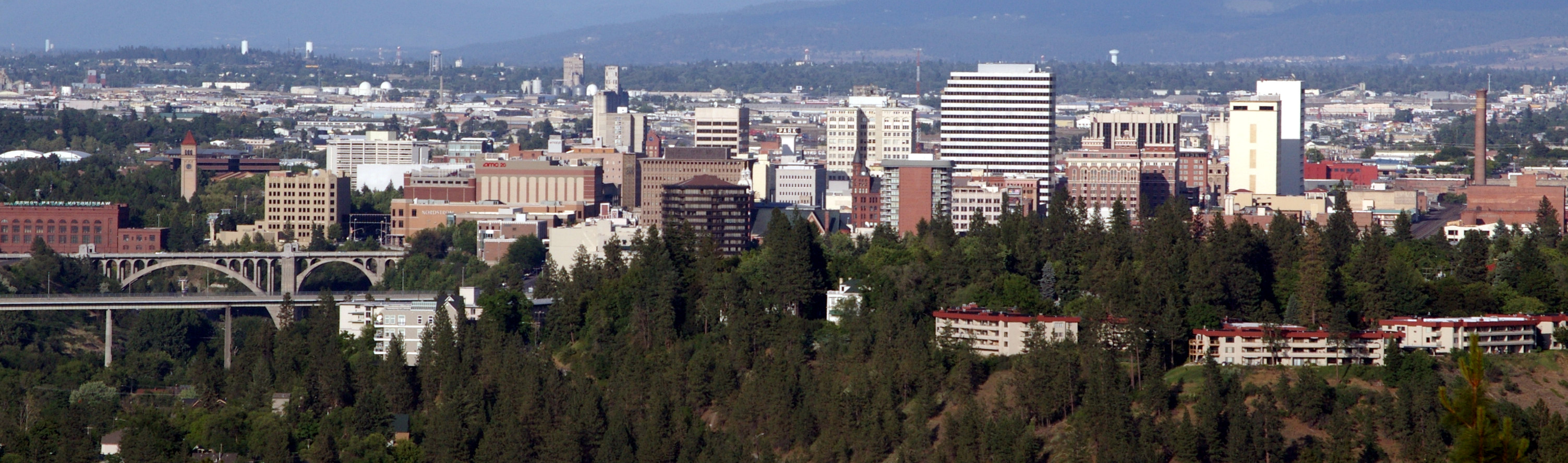
 Panorama of Downtown Spokane looking north. Taken from the Deaconess Medical Center parking garage
See also
- Spokane, Washington
- Spokane, Washington neighborhoods
- National Register of Historic Places listings in Spokane County, Washington
References
- ^ "Welcome to Downtown Spokane". Downtown Spokane Partnership. http://www.downtownspokane.org/. Retrieved 2008-12-14.
- ^ "Hotel History". The Davenport Hotel and Tower. http://www.thedavenporthotel.com/index.php?act=/history. Retrieved 2009-01-25.
- ^ "About The Spokane Convention Center". Spokane Convention Center. http://www.spokanecenter.com/about.php. Retrieved 2009-01-15.
- ^ Boggs, Alison (2006-05-04). "Vox Tower would be Spokane's tallest building". The Spokesman-Review. pp. B3. http://www.spokesmanreview.com/tools/story_pf.asp?ID=129245. Retrieved 2009-01-15.
- ^ a b "Kendall Yards". Black Rock Development. http://blackrockdevelopment.com/index.php?id=4&project=2&title=kendallyards/. Retrieved 2009-01-07.
- ^ a b "About the Park". Riverfront Park. http://www.spokaneriverfrontpark.com/content.php?id=129. Retrieved 2009-01-25.
- ^ "Natatorium Carousel/ Looff Carousel". City-County of Spokane Historic Preservation Office. http://www.historicspokane.org/NationalRegister/nat_carousel.htm. Retrieved 2009-01-25.[dead link]
External links
Categories:- Geography of Spokane, Washington


Wikimedia Foundation. 2010.