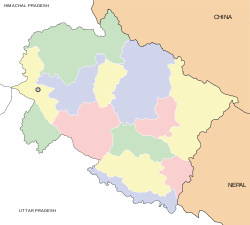
- Chamba, Uttarakhand
-
Chamba — city — Coordinates 30°13′N 78°14′E / 30.21°N 78.23°ECoordinates: 30°13′N 78°14′E / 30.21°N 78.23°E Country India State Uttarakhand District(s) Tehri Garhwal Population
• Density
6,579 (2001[update])
• 1,645 /km2 (4,261 /sq mi)
Time zone IST (UTC+05:30) Area
4 square kilometres (1.5 sq mi)
• 1,524 metres (5,000 ft)
FootnotesChamba (Devanagari:चंबा) is a town and a nagar panchayat in Tehri Garhwal district in the state of Uttarakhand, India. It is situated at the junction of roads leading from Mussoorie, Rishikesh, Tehri Dam/ Lake and New Tehri.
Its nearby tourist places are Dhanaulti, Surkanda Devi Temple, Ranichauri, New Tehri, and Kanatal, midway through Chamba-Dhanaulti road.
About 50 km from Mussoorie is the smal hill town of Chamba, Uttaranchal(of course don't confuse it with Chamba in Himachal).Chamba is yet another of those destinations which still stand oblivious to most tourists and therefore unspoilt and fresh like a daisy for the lucky few who venture out seeking new places to explore and enjoy Chamba is at an altitude of 1600 mt above sea level. Again really unspoiilt and with lot of pines and deodar and good views. Unlike Mussoorie, the place is very quiet and picturesque and an excellent place to relax to wash your city blues. One can reach Chamba in about 7-8 hrs from Delhi via Hardwar, Rishikesh & Narendranagar (290 km). One can also combine stay at Chamba with one at Mussoorie or Dhanolti and reach via Dehradun, Mussoorie and Dhanolti
Demographics
As of 2001[update] India census,[1] Chamba had a population of 6579. Males constitute 59% of the population and females 41%. Chamba has an average literacy rate of 76%, higher than the national average of 59.5%; with male literacy of 82% and female literacy of 68%. 12% of the population is under 6 years of age.
References
- ^ "Census of India 2001: Data from the 2001 Census, including cities, villages and towns (Provisional)". Census Commission of India. Archived from the original on 2004-06-16. http://web.archive.org/web/20040616075334/http://www.censusindia.net/results/town.php?stad=A&state5=999. Retrieved 2008-11-01.
External links
·
Cities and towns in Tehri Garhwal Tehri Garhwal Chamba · Devprayag · Dhanaulti · Dhaluwala · Kirtinagar · Muni Ki Reti · Narendra Nagar · Tehri
Cities and towns
in other districtsAlmora · Bageshwar · Chamoli · Champawat · Dehradun · Haridwar · Nainital · Pauri Garhwal · Pithoragarh · Rudraprayag · Udham Singh Nagar · Uttarkashi
Categories:- Cities and towns in Tehri Garhwal district
- Tehri
- Uttarakhand geography stubs
Wikimedia Foundation. 2010.


