- National Register of Historic Places listings in Jackson County, Oregon
-
 Medford Carnegie Library, in Medford
This is a list of properties and districts in Jackson County, Oregon that are listed on the National Register of Historic Places.
Contents
Current listings
[1] Landmark name Image Date listed Location City or town Summary 1 Nils Ahlstrom House 
February 15, 1980 248 5th St.
42°11′46″N 122°42′18″W / 42.196111°N 122.705°WAshland 2 Thomas N. Anderson House 
June 1, 1990 719 Second Ave.
42°25′56″N 123°03′06″W / 42.432222°N 123.051667°WGold Hill 3 Ashland Cemetery 
June 8, 1995 Jct. of E. Main and Morton Sts.
42°11′38″N 122°42′14″W / 42.193889°N 122.703889°WAshland 4 Ashland Depot Hotel, South Wing 
February 19, 1991 624 A St.
42°11′53″N 122°42′16″W / 42.198056°N 122.704444°WAshland 5 Ashland Downtown Historic District 
May 5, 2000 Roughly bounded by Lithia Way/C St., Church, Lithia Park/Hargadine, and Gresham Sts.
42°11′47″N 122°42′42″W / 42.196389°N 122.711667°WAshland 6 Ashland Masonic Lodge Building 
June 4, 1992 25 N. Main St.
42°11′49″N 122°42′52″W / 42.196944°N 122.714444°WAshland 7 Ashland Municipal Powerhouse 
September 10, 1987 Ashland Creek Canyon
42°10′09″N 122°42′46″W / 42.169167°N 122.712778°WAshland 8 Ashland Oregon National Guard Armory 
September 10, 1987 208 Oak St.
42°11′56″N 122°42′43″W / 42.198889°N 122.711944°WAshland 9 Ashland Railroad Addition Historic District May 5, 1999 Roughly bounded by Lithia Way, East Main, Oak St., A St. and 8th Sts.
42°11′48″N 122°42′22″W / 42.196667°N 122.706111°WAshland 10 W. H. Atkinson House 
October 16, 1979 125 N. Main St.
42°11′56″N 122°42′57″W / 42.198889°N 122.715833°WAshland 11 Sophenia Ish Baker House September 9, 1993 902 W. McAndrews Rd.
42°19′53″N 122°53′31″W / 42.331389°N 122.891944°WMedford 12 Barclay-Klum House June 1, 1990 102 E. Main St.
42°11′39″N 122°42′00″W / 42.194167°N 122.7°WAshland 13 Barnum Hotel 
March 22, 1984 204 N. Front St.
42°19′43″N 122°52′26″W / 42.328611°N 122.873889°WMedford 14 Baldwin Beach House 
March 28, 1979 348 Hargadine St.
42°11′39″N 122°42′38″W / 42.194167°N 122.710556°WAshland 15 Robert Vinton Beall House October 18, 1979 S of Central Point at 1253 Beall Lane
42°21′12″N 122°54′32″W / 42.353333°N 122.908889°WCentral Point 16 Beeson-Foss Ranch January 27, 1999 6371 Wagner Creek Rd.
42°14′00″N 122°47′30″W / 42.233333°N 122.791667°WTalent 17 Big Elk Guard Station December 29, 2000 FS Rd. 3706 approx. 5 mi. N. of Dead Indian Memorial Rd.
42°21′32″N 122°21′24″W / 42.358889°N 122.356667°WAshland 18 Boslough-Claycomb House December 9, 1981 1 Hillcrest St.
42°11′35″N 122°42′40″W / 42.193056°N 122.711111°WAshland 19 Walter Bowne House February 23, 1990 1845 Old Stage Rd.
42°20′35″N 122°57′06″W / 42.343056°N 122.951667°WJacksonville 20 BPOE Lodge No. 1168 November 28, 1980 202 N. Central Ave.
42°20′04″N 122°52′21″W / 42.334444°N 122.8725°WMedford 21 Buckhorn Mineral Springs Resort March 3, 1989 2200 Buckhorn Springs Rd.
42°06′20″N 122°31′46″W / 42.105556°N 122.529444°WAshland 22 Victor and Bertha Bursell House April 29, 1982 3075 Hanley Rd.
42°21′39″N 122°55′42″W / 42.360833°N 122.928333°WCentral Point 23 Butte Falls Ranger Station April 11, 1986 Rogue River National Forest
42°32′28″N 122°33′48″W / 42.541111°N 122.563333°WButte Falls 24 Frank E. Bybee House December 9, 1981 4491 Jacksonville Hwy.
42°19′30″N 122°56′31″W / 42.325°N 122.941944°WJacksonville 25 William Bybee House February 15, 1977 883 Old Stage Rd.
42°19′17″N 122°57′51″W / 42.321389°N 122.964167°WMedford 26 Richard Posey Campbell House February 12, 1980 94 Bush St.
42°11′58″N 122°43′02″W / 42.199444°N 122.717222°WAshland 27 A. S. V. Carpenter and Helen Bundy House December 23, 2005 1677 Old Stage Rd.
42°20′29″N 122°57′31″W / 42.341389°N 122.958611°WCentral Point 28 E. V. Carter House 
March 7, 1979 505 Siskiyou Blvd.
42°11′37″N 122°42′25″W / 42.193611°N 122.706944°WAshland 29 H. B. Carter House November 2, 1977 91 Gresham St.
42°11′35″N 122°42′34″W / 42.193056°N 122.709444°WAshland 30 Carter-Fortmiller House 
December 21, 1981 514 Siskiyou Blvd.
42°11′35″N 122°42′26″W / 42.193056°N 122.707222°WAshland 31 Central Point Public School December 3, 1980 450 S. 4th St.
42°22′17″N 122°54′39″W / 42.371389°N 122.910833°WCentral Point 32 Chappell-Swedenburg House 
November 30, 1982 990 Siskiyou Blvd.
42°11′19″N 122°41′52″W / 42.188611°N 122.697778°WAshland 33 Chavner Family House 
May 31, 1996 12162 Blackwell Rd.
42°25′50″N 123°02′03″W / 42.430556°N 123.034167°WGold Hill 34 Citizen's Banking & Trust Co. Building 
February 28, 1985 232-242 E. Main St.
42°11′43″N 122°42′40″W / 42.195278°N 122.711111°WAshland 35 Frank Chamberlain Clark House October 29, 1982 1917 E. Main St.
42°19′43″N 122°50′45″W / 42.328611°N 122.845833°WMedford 36 Cooley-Neff Warehouse September 6, 2007 340 N. Fir St.
42°19′44″N 122°52′32″W / 42.328889°N 122.875556°WMedford 37 Orlando Coolidge House 
February 12, 1980 137 N. Main St.
42°11′58″N 122°42′59″W / 42.199444°N 122.716389°WAshland 38 Corning Court Ensemble February 19, 1991 5-16 Corning Ct.
42°19′39″N 122°51′48″W / 42.3275°N 122.863333°WMedford 39 Dead Indian Soda Springs Shelter 
December 29, 2000 Near end of S. Fork Little Butte Cr. Rd.
42°20′17″N 122°27′01″W / 42.338056°N 122.450278°WEagle Point 40 E. Raymond Driver House March 9, 1990 4140 Old Stage Rd.
42°22′39″N 122°57′19″W / 42.3775°N 122.955278°WCentral Point 41 Patrick Dunn Ranch March 8, 1978 SE of Ashland on OR 66
42°09′56″N 122°38′28″W / 42.165556°N 122.641111°WAshland 42 Dutchman Peak Lookout December 29, 2000 FS Rd. 20 approx. 25 mi. SW of Ashland
42°02′37″N 122°53′23″W / 42.043611°N 122.889722°WAshland 43 Eddings-Provost House November 6, 1980 364 Vista St.
42°11′35″N 122°42′36″W / 42.193056°N 122.71°WAshland 44 Eden Valley Orchard July 14, 2000 2488 Voorhies Rd.
42°17′19″N 122°50′48″W / 42.288611°N 122.846667°WMedford 45 H. Chandler and Alice B. Egan House February 21, 1997 2620 Foothill Rd.
42°21′11″N 122°49′17″W / 42.353056°N 122.821389°WMedford 46 Enders Building 
October 23, 1986 250-300 E. Main St.
42°11′43″N 122°42′38″W / 42.195278°N 122.710556°WAshland 47 Edward Charles Faber House February 21, 1997 445 Manzanita St.
42°22′37″N 122°54′49″W / 42.376944°N 122.913611°WCentral Point 48 First Baptist Church 
March 28, 1979 241 Hargadine St.
42°11′43″N 122°42′42″W / 42.195278°N 122.711667°WAshland 49 First National Bank, Vaupel Store and Oregon Hotel Buildings February 29, 1980 15 S. Pioneer St. and 70 E. Main St.
42°11′48″N 122°42′48″W / 42.196667°N 122.713333°WAshland 50 Fish Lake Shelter December 29, 2000 South of OR 140 approx. 25 mi. NE of Ashland
42°23′38″N 122°19′01″W / 42.393889°N 122.316944°WAshland 51 Fluhrer Bakery Building May 16, 1983 29 N. Holly St.
42°19′30″N 122°52′31″W / 42.325°N 122.875278°WMedford 52 Fort Lane Military Post Site September 20, 1988 Address Restricted Central Point 53 Andrew J. Fredenburg House June 17, 1982 234 S. Holly St.
42°19′23″N 122°52′21″W / 42.323056°N 122.8725°WMedford 54 Frederic E. Furry House February 29, 1980 SE of Medford at 1720 N. Phoenix Rd.
42°18′20″N 122°49′10″W / 42.305556°N 122.819444°WMedford 55 C. E. "Pop" Gates House February 19, 1991 1307 Queen Anne Ave.
42°19′50″N 122°51′20″W / 42.330556°N 122.855556°WMedford 56 Glenview Orchard Ensemble October 23, 1986 1395 Carpenter Hill Rd.
42°16′46″N 122°52′08″W / 42.279444°N 122.868889°WPhoenix 57 Gold Hill High School February 20, 1991 806 6th Ave.
42°26′05″N 123°03′13″W / 42.434722°N 123.053611°WGold Hill 58 G. M. and Kate Grainger House 
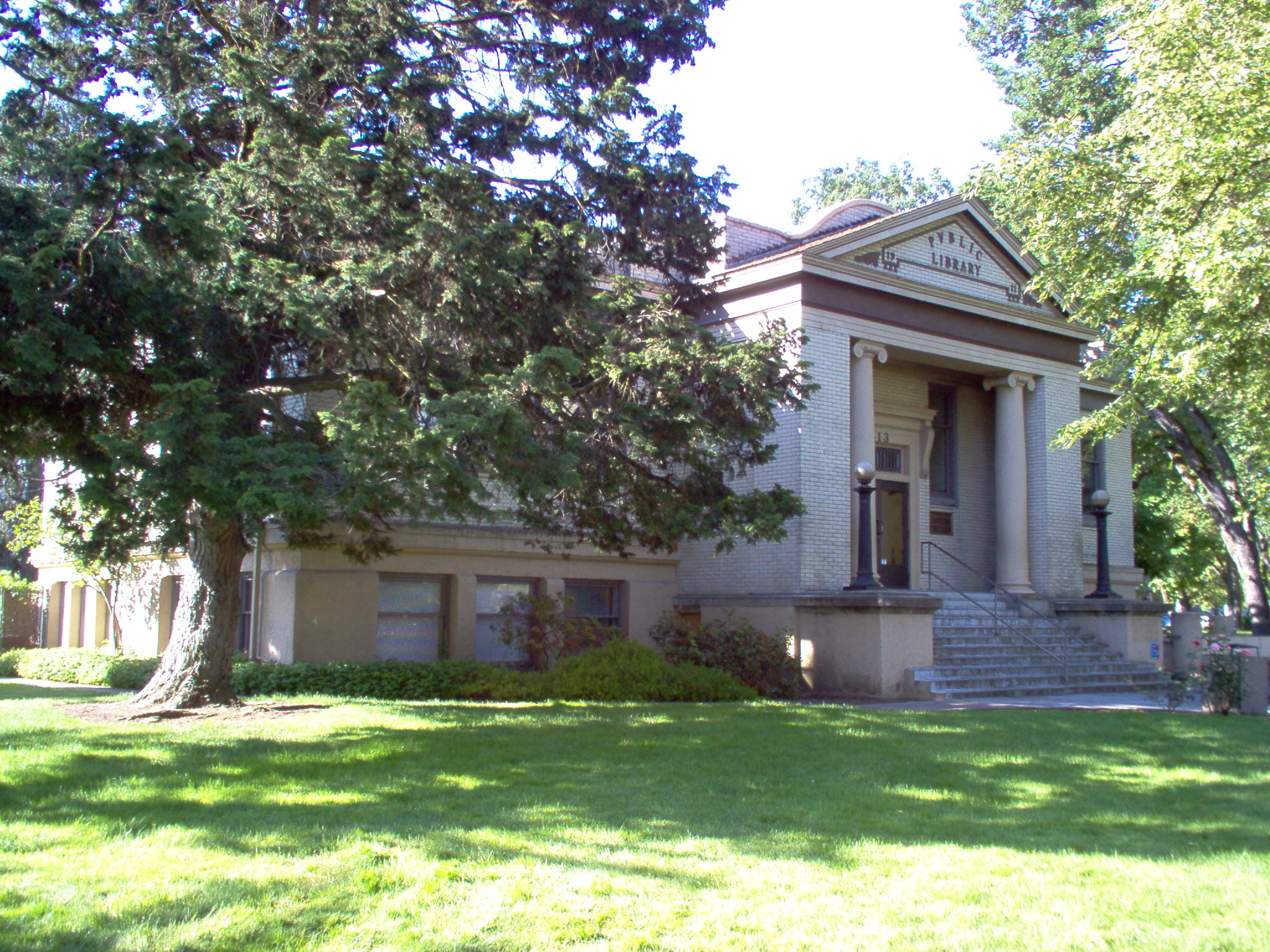
February 23, 1990 35 Granite St.
42°11′50″N 122°42′58″W / 42.197222°N 122.716111°WAshland 59 Edgar F. Hafer House September 1, 1983 426 W. 6th St.
42°19′29″N 122°52′38″W / 42.324722°N 122.877222°WMedford 60 Michael Hanley Farmstead November 25, 1983 1053 Hanley Rd.
42°20′08″N 122°55′54″W / 42.335556°N 122.931667°WMedford 61 Hanscom Hall June 3, 1996 201 Talent Ave.
42°14′39″N 122°47′05″W / 42.244167°N 122.784722°WTalent 62 Hargadine Cemetery 
June 3, 1998 Sheridan and Walnut Sts.
42°12′35″N 122°43′34″W / 42.209722°N 122.726111°WAshland 63 Charles and Elizabeth Hatch House June 23, 2011 199 1st St.
42°26′06″N 123°10′08″W / 42.435°N 123.168889°WRogue River 64 Hillcrest Orchard Historic District February 16, 1984 3285 Hillcrest Rd.
42°19′55″N 122°49′12″W / 42.331944°N 122.82°WMedford 65 George A. Hover House September 8, 1980 4192 Coleman Creek Rd.
42°15′48″N 122°50′24″W / 42.263333°N 122.84°WMedford 66 Imnaha Guard Station 
April 11, 1986 Rogue River National Forest
42°42′13″N 122°19′53″W / 42.703611°N 122.331389°WButte Falls 67 IOOF Building 
February 17, 1978 49-57 N. Main St.
42°11′50″N 122°42′54″W / 42.197222°N 122.715°WAshland 68 Jackson County Courthouse October 23, 1986 S. Oakdale Ave. at Eighth St.
42°19′23″N 122°52′37″W / 42.323056°N 122.876944°WMedford 69 Jacksonville Historic District 
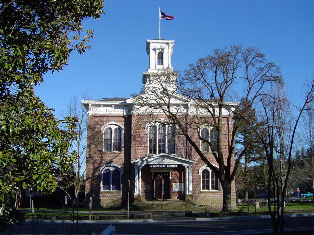
November 13, 1966 Jacksonville city limits
42°18′45″N 122°58′00″W / 42.3125°N 122.966667°WJacksonville 70 Jacksonville-to-Fort Klamath Military Wagon Road May 16, 1979 S of Butte Falls
42°28′46″N 122°26′57″W / 42.479444°N 122.449167°WButte Falls 71 E. C. Kane House 
November 6, 1986 386 B St.
42°11′49″N 122°42′29″W / 42.196944°N 122.708056°WAshland 72 Liberty Building March 14, 1978 201 W. Main St.
42°19′30″N 122°53′11″W / 42.325°N 122.886389°WMedford 73 Lithia Park 
November 22, 1982 59 Winburn Way
42°11′49″N 122°43′05″W / 42.196944°N 122.718056°WAshland 74 Lithia Springs Hotel 
March 14, 1978 212 E. Main St.
42°11′44″N 122°42′43″W / 42.195556°N 122.711944°WAshland 75 Lodgepole Guard Station March 6, 1991 SE of Prospect, Rogue R. NF
42°39′15″N 122°22′39″W / 42.654167°N 122.3775°WButte Falls 76 Lost Creek Bridge 
November 29, 1979 SE of Lake Creek
42°25′21″N 122°44′56″W / 42.4225°N 122.748889°WLake Creek 77 Robert and Ruth Lucas House and Mary E. Rose House July 21, 1988 59, 77 Sixth St.
42°11′42″N 122°42′17″W / 42.195°N 122.704722°WAshland 78 Madden-McCaskey House January 21, 1994 3347 Old Stage Rd.
42°21′53″N 122°56′56″W / 42.364722°N 122.948889°WCentral Point 79 John McCall House 
December 9, 1981 153 Oak St.
42°11′52″N 122°42′49″W / 42.197778°N 122.713611°WAshland 80 William McCredie House September 17, 1980 2685 Old Stage Rd.
42°21′21″N 122°56′40″W / 42.355833°N 122.944444°WCentral Point 81 McKee Bridge November 29, 1979 S of Ruch
42°07′34″N 123°04′19″W / 42.126111°N 123.071944°WRuch 82 McKee Bridge Campground December 29, 2000 Upper Applegate Rd. approx. 7 mi. S of OR 238
42°07′42″N 123°04′14″W / 42.128333°N 123.070556°WJacksonville 83 Patrick F. McManus House March 8, 1978 117 W. 1st St.
42°16′22″N 122°48′54″W / 42.272778°N 122.815°WPhoenix 84 Medford Carnegie Library 
July 30, 1981 413 W. Main St.
42°19′25″N 122°52′32″W / 42.323611°N 122.875556°WMedford 85 Medford Central Firehall February 23, 1996 110 E. Sixth St.
42°19′38″N 122°52′21″W / 42.327222°N 122.8725°WMedford 86 Medford Downtown Historic District August 14, 1998 Roughly between Fourth and Ninth Sts., Oakdale and Riverside Aves.
42°19′36″N 122°52′23″W / 42.326667°N 122.873056°WMedford 87 Medford Geneva-Minnesota Historic District January 21, 1994 Geneva and Minnesota Sts., from E. Main to Crater Lake Ave.
42°19′46″N 122°51′49″W / 42.329444°N 122.863611°WMedford 88 Medford Grocery Company Warehouse June 20, 2002 40 E. 10th St.
42°19′25″N 122°52′11″W / 42.323611°N 122.869722°WMedford 89 Medford IOOF Cemetery 
March 16, 1989 Siskiyou Blvd. at Highland Dr.
42°19′16″N 122°51′00″W / 42.321122°N 122.850075°WMedford 90 Medford Plaza Apartments June 16, 2004 235 S. Oakdale Ave.
42°19′18″N 122°52′27″W / 42.321667°N 122.874167°WMedford 91 Medford Southern Pacific Railroad Passenger Depot June 3, 1996 147 N. Front St.
42°19′40″N 122°52′25″W / 42.327778°N 122.873611°WMedford 92 John W. Merritt House and Store March 9, 1992 117 E. Pine St.
42°22′29″N 122°54′57″W / 42.374722°N 122.915833°WCentral Point 93 Mountain House January 21, 2004 1148 Old Highway 99 South
42°07′33″N 122°36′30″W / 42.125833°N 122.608333°WAshland 94 Mountain View Cemetery June 8, 1995 Jct. of Normal Ave. and OR 66
42°11′08″N 122°40′53″W / 42.185556°N 122.681389°WAshland 95 Mt. Stella Lookout December 29, 2000 Approx. 2.5 mi. N of Union Cr.
42°56′15″N 122°26′02″W / 42.9375°N 122.433889°WProspect 96 Amos and Vera Nininger House October 29, 1982 80 Hargadine St.
42°11′44″N 122°42′50″W / 42.195556°N 122.713889°WAshland 97 John Orth House April 11, 1972 Main and 3rd Sts.
42°18′50″N 122°58′02″W / 42.313889°N 122.967222°WJacksonville 98 Parker Meadows Shelter December 29, 2000 Near Forest Rd. 37 approx. 15 mi. NE. of Butte Falls
42°36′04″N 122°19′25″W / 42.601111°N 122.323611°WButte Falls 99 Reginald Parsons Dead Indian Lodge June 13, 1997 Hyatt Prairie Rd. 21 mi. E of Ashland
42°13′35″N 122°24′51″W / 42.226389°N 122.414167°WAshland 100 Hamilton and Edith Patton House September 9, 1993 245 Valley View Dr.
42°19′57″N 122°50′32″W / 42.3325°N 122.842222°WMedford 101 S. and Sarah J. Pedigrift House February 20, 1992 407 Scenic Ave.
42°12′14″N 122°43′19″W / 42.203889°N 122.721944°WAshland 102 Peerless Rooms Building 
October 8, 1992 243-249 Fourth St.
42°11′52″N 122°42′23″W / 42.197778°N 122.706389°WAshland 103 Emil and Alice Applegate Peil House 
February 20, 1992 52 Granite St.
42°11′48″N 122°42′57″W / 42.196667°N 122.715833°WAshland 104 John and Charlotte Pelton House 
September 9, 1993 228 B St.
42°11′51″N 122°42′37″W / 42.1975°N 122.710278°WAshland 105 Domingo Perozzi House 
February 12, 1980 88 Granite St.
42°11′44″N 122°42′59″W / 42.195556°N 122.716389°WAshland 106 Dr. E.B. Pickel Rental House October 29, 1982 815 W. Main St.
42°19′25″N 122°52′49″W / 42.323611°N 122.880278°WMedford 107 Humboldt Pracht House December 23, 1981 234 Vista St.
42°11′38″N 122°42′46″W / 42.193889°N 122.712778°WAshland 108 Prospect Hotel 
February 12, 1980 39 Mill Creek Dr.
42°45′04″N 122°29′12″W / 42.751111°N 122.486667°WProspect 109 Putnam-Neff House April 25, 2008 227 N. Berkeley Wy.
42°19′49″N 122°51′00″W / 42.330222°N 122.849922°WMedford 110 Alfred Evan Reames House February 20, 1991 816 W. Tenth St.
42°19′17″N 122°52′44″W / 42.321389°N 122.878889°WMedford 111 Dr. John F. and Mary Reddy House 
September 10, 1987 122 Oregon Terr.
42°19′49″N 122°51′11″W / 42.330278°N 122.853056°WMedford 112 Rich Gulch Diggings March 23, 2000 0.75 mi SW of Jacksonville
42°18′33″N 122°58′46″W / 42.309167°N 122.979444°WJacksonville 113 Rock Point Hotel September 4, 1980 40 N. River Rd.
42°26′00″N 123°05′27″W / 42.433333°N 123.090833°WGold Hill 114 Rogue Elk Hotel 
February 22, 1980 27390 OR 62
42°39′44″N 122°45′25″W / 42.662222°N 122.756944°WTrail 115 Root-Banks House August 5, 1994 11 N. Peach St. (1000 W. Main St.)
42°19′27″N 122°52′54″W / 42.324167°N 122.881667°WMedford 116 Fordyce Roper House-Southern Oregon Hospital December 2, 1985 35 S. Second St.
42°11′42″N 122°42′38″W / 42.195°N 122.710556°WAshland 117 Schuler Apartment Building June 19, 1991 38 N. Oakdale Ave.
42°19′28″N 122°52′37″W / 42.324444°N 122.876944°WMedford 118 Shone-Charley House October 25, 1984 305 N. Grape St.
42°19′40″N 122°52′37″W / 42.327778°N 122.876944°WMedford 119 Col. William H. Silsby House 
February 28, 1985 111 3rd St.
42°11′46″N 122°42′30″W / 42.196111°N 122.708333°WAshland 120 Siskiyou-Hargandine Historic District September 14, 2002 Roughly bounded by East Main, Morse, Beach, Iowa, and Pioneer Sts.
42°11′30″N 122°42′25″W / 42.191667°N 122.706944°WAshland 121 Skidmore Academy Historic District August 14, 2001 Roughly bounded by the RR R-O-W, Granite, Scenic, and Maple Sts.
42°11′59″N 122°43′04″W / 42.199722°N 122.717778°WAshland 122 Snowy Butte Flour Mill September 1, 1976 Off OR 62
42°28′27″N 122°47′50″W / 42.474167°N 122.797222°WEagle Point 123 South Oakdale Historic District March 15, 1979 Irregular pattern along S. Oakdale Ave. from Stewart Ave. to W. 10th St.
42°19′03″N 122°52′27″W / 42.3175°N 122.874167°WMedford 124 Sparta Building October 8, 1992 12 N. Riverside St.
42°19′41″N 122°52′10″W / 42.328056°N 122.869444°WMedford 125 Squaw Peak Lookout December 29, 2000 Approx. 8 mi. S of FS Rd. 20, 25 mi. S of Jacksonville
42°04′10″N 123°00′40″W / 42.069444°N 123.011111°WJacksonville 126 Star Ranger Station March 6, 1991 E of Applegate R., Rogue R. NF
42°09′02″N 123°03′31″W / 42.150556°N 123.058611°WRuch 127 Star Ranger Station Building, Old December 29, 2000 6941 Upper Applegate Rd.
42°09′01″N 123°03′29″W / 42.150278°N 123.058056°WJacksonville 128 Dr. Charles T. and Mary Sweeney House June 4, 1992 2336 Table Rock Rd.
42°21′09″N 122°53′02″W / 42.3525°N 122.883889°WMedford 129 George Taverner House 
November 7, 1978 912 Siskiyou Blvd.
42°11′20″N 122°41′58″W / 42.188889°N 122.699444°WAshland 130 Tayler-Phipps Building February 23, 1990 221-225 E. Main St.
42°19′37″N 122°52′16″W / 42.326944°N 122.871111°WMedford 131 Trinity Episcopal Church April 5, 1984 44 N. 2nd St.
42°11′43″N 122°42′35″W / 42.195278°N 122.709722°WAshland 132 U.S. Post Office and Courthouse 
April 30, 1979 310 W. 6th St.
42°19′16″N 122°52′29″W / 42.321111°N 122.874722°WMedford 133 Union Creek Historic District 
October 29, 1980 OR 62
42°54′15″N 122°27′01″W / 42.904167°N 122.450278°WProspect 134 Henry Van Hoevenberg, Jr., House December 10, 1981 9130 Ramsey Canyon Rd.
42°30′19″N 122°59′36″W / 42.505278°N 122.993333°WGold Hill 135 Wagner Creek School October 8, 1992 8448 Wagner Creek Rd.
42°12′45″N 122°47′27″W / 42.2125°N 122.790833°WTalent 136 John P. Walker House March 14, 1978 1521 E. Main St.
42°11′46″N 122°41′17″W / 42.196111°N 122.688056°WAshland 137 Mathias Welch House June 4, 1998 162 N. Second St.
42°22′35″N 122°54′59″W / 42.376389°N 122.916389°WCentral Point 138 West Side Feed and Sale Stable December 21, 1981 29 S. Grape St.
42°19′29″N 122°52′23″W / 42.324722°N 122.873056°WMedford 139 Whaleback Snow-Survey Cabin December 29, 2000 Approx. 10 mi. N of Prospect
42°54′41″N 122°34′47″W / 42.911389°N 122.579722°WProspect 140 John B. White House November 2, 1978 86 N. River Rd.
42°26′00″N 123°05′28″W / 42.433333°N 123.091111°WRock Point 141 Harry L. Whited House 
June 3, 1998 321 N. Main
42°12′10″N 122°43′06″W / 42.202778°N 122.718333°WAshland 142 Whittle Garage Building 
March 7, 1997 101 Oak St.
42°11′52″N 122°42′48″W / 42.197778°N 122.713333°WAshland 143 Wilkinson-Swem Building August 26, 1982 217 E. Main St.
42°19′38″N 122°52′15″W / 42.327222°N 122.870833°WMedford 144 Willow Prairie Cabin 
December 29, 2000 FS Rd. 37 approx. 1.5 mi. N. of Butte Falls
42°24′23″N 122°23′30″W / 42.406389°N 122.391667°WButte Falls 145 Women's Civic Improvement Clubhouse 
June 16, 1989 59 Winburn Way
42°11′46″N 122°42′55″W / 42.196111°N 122.715278°WAshland 146 Isaac Woolen House 
October 16, 1979 131 N. Main St.
42°11′57″N 122°42′59″W / 42.199167°N 122.716389°WAshland 147 Wrangle Gap Shelter December 29, 2000 FS Rd. 20 approx. 25 mi. SW of Ashland
42°03′02″N 122°51′18″W / 42.050556°N 122.855°WAshland Former listings
Landmark name Image Date listed/removed Location City or Town Summary 1 Antelope Creek Bridge Listed November 29, 1979
Removed April 18, 1988Medford Covered bridge that formerly crossed Antelope Creek. Later moved, but changes reduced the integrity and it was delisted from the National Register. 2 Samuel Colver House Listed October 25, 1990
Removed April 15, 2009150 Main St.
42°16′17″N 122°48′42″W / 42.27139°N 122.81167°WPhoenix Home of settler Samuel Colver. A fire destroyed the building on September 15, 2008.[2] Delisted April 15, 2009. 3 Conro Fiero House Listed December 9, 1981
Removed June 1, 20114615 Hamrick Rd.
42°23′1″N 122°53′34″W / 42.38361°N 122.89278°WCentral Point Known as the Mon Desir restaurant when destroyed by fire January 10, 2010[3] See also
References
- ^ Numbers represent an ordering by significant words. Various colorings, defined here, differentiate National Historic Landmark sites and National Register of Historic Places Districts from other NRHP buildings, structures, sites or objects.
- ^ Achen, Paris (September 15, 2008). "Fire destroys Colver House". Mail Tribune (Medford, Oregon). http://www.mailtribune.com/apps/pbcs.dll/article?AID=/20080915/NEWS07/80915004. Retrieved June 15, 2011.
- ^ Burke, Anita (October 16, 2010). "Fiery end to Mon Desir". Mail Tribune (Medford, Oregon). http://www.mailtribune.com/apps/pbcs.dll/article?AID=/20100112/NEWS/1120313&cid=sitesearch. Retrieved June 15, 2011.
External links
 Media related to Registered Historic Places in Jackson County, Oregon at Wikimedia Commons
U.S. National Register of Historic Places Topics Lists by states Alabama • Alaska • Arizona • Arkansas • California • Colorado • Connecticut • Delaware • Florida • Georgia • Hawaii • Idaho • Illinois • Indiana • Iowa • Kansas • Kentucky • Louisiana • Maine • Maryland • Massachusetts • Michigan • Minnesota • Mississippi • Missouri • Montana • Nebraska • Nevada • New Hampshire • New Jersey • New Mexico • New York • North Carolina • North Dakota • Ohio • Oklahoma • Oregon • Pennsylvania • Rhode Island • South Carolina • South Dakota • Tennessee • Texas • Utah • Vermont • Virginia • Washington • West Virginia • Wisconsin • WyomingLists by territories Lists by associated states Other U.S. National Register of Historic Places in Oregon Lists by county Baker • Benton • Clackamas • Clatsop • Columbia • Coos • Crook • Curry • Deschutes • Douglas • Gilliam • Grant • Harney • Hood River • Jackson • Jefferson • Josephine • Klamath • Lake • Lane • Lincoln • Linn • Malheur • Marion • Morrow • Multnomah: Portland North • Multnomah: Portland Northeast • Multnomah: Portland Northwest • Multnomah: Portland Southeast • Multnomah: Portland Southwest • Multnomah: Other • Polk • Sherman • Tillamook • Umatilla • Union • Wallowa • Wasco • Washington • Wheeler • Yamhill
Other lists Municipalities and communities of Jackson County, Oregon Cities Ashland | Butte Falls | Central Point | Eagle Point | Gold Hill | Jacksonville | Medford | Phoenix | Rogue River | Shady Cove | Talent

CDP Unincorporated
communitiesApplegate | Buncom | Lake Creek | McKee Bridge | McLeod | Mountain View | Pinehurst | Prospect | Provolt | Rock Point | Ruch | Sams Valley | Starvation Heights | Tolo | Trail | Union Creek | Wimer
Ghost towns Copper | Sterlingville
Categories:- National Register of Historic Places in Jackson County, Oregon


Wikimedia Foundation. 2010.