- M-43 (Michigan highway)
-
This article is about the state highway in Michigan; for other uses, see M43 (disambiguation)
M-43
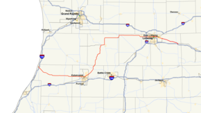
M-43 highlighted in redRoute information Maintained by MDOT Length: 136.723 mi[1] (220.034 km) Existed: 1924 – present Major junctions West end:  BL I-196 in South Haven
 M-40 near Gobles
 US 131 near Kalamazoo
 M-37 in Hastings

 M-50 / M-66 near Woodland

 I-96 / I-69 near Lansing
 US 127 near East Lansing
East end: I-96 near WebbervilleLocation Counties: Van Buren, Kalamazoo, Barry, Eaton, Ingham Highway system Michigan State Trunkline Highway System
Interstate • US • State←  M-42
M-42M-44  →
→M-43 is a state trunkline highway in southwestern and central parts of the US state of Michigan. The highway runs from South Haven to Webberville along an indirect path through both rural areas and larger cities. The trunkline follows three overall segments: a southeasterly track from South Haven to Kalamazoo, a northeasterly course to the Hastings area and an easterly route through the Lansing area.
The M-43 designation dates back to at least July 1, 1919, when it was used on a series of roadways running between Kalamazoo and St. Charles. Its northern- and easternmost sections were transferred to other highways in the 1930s. Additions to M-43 extended it to its current termini. Several sections of the highway were realigned during its history, one of these changes led to the creation of a business loop in Grand Ledge. Another former segment of the trunkline in the Lansing area has been renumbered M-143.
Contents
Route description
M-43 begins at an intersection with BL I-196 in South Haven. Known locally as Bailey Avenue, the road heads out of the city to the southwest, intersecting County Road A-2 before running under Interstate 196 (I-196). From there, the road continues to the southeast near the airport through the rural areas of Van Buren County. The road runs through mixed woodland and fields before passing through Bangor. After Bangor, the route heads due east past Glendale and then intersects M-40 north of Paw Paw.[2][3]
After the junction with M-40, the highway then enters Kalamazoo County and has an interchange with US Highway 131 (US 131) just before entering the city of Kalamazoo on Main Street near the north side of the campus of Western Michigan University. Through downtown, M-43 runs concurrently with both of the city's business loops for I-94 and US 131. Eastbound traffic along the combined highway is routed on Michigan Avenue, while westbound traffic uses Kalamazoo Avenue. Business US 131 (BUS US 131) turns north at Park Street and BL I-94/M-43 continues east. After the two traffic directions merge back together and cross the Kalamazoo River, BL I-94 turns to the southeast, and M-43 follows Riverview Drive to an intersection with Gull Road. There M-43 begins to head northeast out of the city. The highway passes in front of the Borgess Medical Center and along a row of retail and commercial properties next to Gull Road. The trunkline then travels through a rural area for a brief period before entering the community of Richland where it merges with M-89.[2][3]
M-43 and M-89 run concurrently for a mile north of Richland before M-89 heads off to the east while M-43 continues north. After the concurrency ends, M-43 turns east and then back north to run between Little Long and Gull lakes. It is at this point where M-43 begins its northward trek. The road continues on a general north-northeast track through rural areas and beside several lakes in Barry County before meeting M-179 and M-37. M-43 merges with the latter highway and together they run into Hastings. Downtown, M-37 leaves town to the south, while M-43 heads north before curving around the east, passing through farmfields approaching the community of Woodland. After leaving town, the road meets M-66, and together they head north to a junction with M-50.[2][3]
 M-43 running along Grand River Avenue at Collingwood Drive in East Lansing
M-43 then turns east with M-50, and they briefly run together before M-50 diverges to the southeast. Now known as the Grand Ledge Highway, M-43 continues its easterly path across northern Eaton County before dipping south briefly to travel around the south side of Grand Ledge. Just south of town, M-43 has a junction with M-100 and then follows Saginaw Highway. The highway then has a junction with I-96/I-69 in Delta Township before continuing into Lansing, merged with BL I-69.[2][3]
In Lansing, the highway travels splits to follow the one-way streets of Saginaw (eastbound) and Oakland (westbound) near the Sparrow Specialty Hospital. BL I-69/M-43 then crosses the Grand River and passes Marshall Park. The trunkline then passes over US 127 just before the paired one-way streets merge back together on Grand River Avenue. After the merge, M-43 heads southeast through East Lansing, passing the main campus of Michigan State University and Spartan Stadium. The road continues on its southeast path, traveling by the Meridian Mall as it enters Meridian Township. From here the road travels through Williamston before terminating at an interchange with I-96 just south of Webberville at exit 122.[2][3]
The Michigan Department of Transportation (MDOT) maintains M-43 like all other state trunkline highways. As a part of those responsibilities, the department tracks the volume of traffic along its roadways using a metric called average annual daily traffic. This is a calculation of the traffic levels for a roadway segment for any average day of the year. In 2009, MDOT determined that the highest traffic volume along M-43 was east of the I-96/I-69 interchange at 38,927 vehicles per day. The highest commercial traffic was west of the interchange at 645 trucks daily. The lowest volumes were at Woodland with only 1,700 vehicles and 120 trucks traveling along that section of the highway daily.[4] Two segments of M-43 are listed on the National Highway System. The first section runs from US 131 in Oshtemo Township east to the intersection of M-43 (Gull Road) and Sprinkle Road in Comstock.[5] The second segment is between I-96/I-69 in Delta Township and the junction between Saginaw Street and Grand River Avenue in East Lansing.[6]
History
When M-43 was first commissioned by July 1, 1919, it ran from M-17 in Kalamazoo to Hastings. It also extended north to Ionia and Stanton before turning east through Ithaca to St. Charles.[7] In 1929, the western end was extended from Kalamazoo to South Haven, with a section still under construction.[8][9] By the end of 1930, the sections of M-43 north and east of Woodbury were redesignated as parts of other highways. The Woodbury–Stanton segment was renumbered M-14, and the Stanton – St. Charles highway became M-57.[10] In 1938, the road was extended to the east, replacing the routing of M-39 from Woodbury all the way to East Lansing where it intersected US 16 as it existed on Grand River Avenue.[11][12]
The next year, M-37 was realigned, which created a concurrency with M-43 in the Hasting area.[13][14] When M-43 was rerouted in 1954, the new course of the highway ran concurrently with M-66 for a few miles in rural northeastern Barry County.[15][16] All of the highway was completely paved in 1956 when a new routing opened northeast of Hastings, bypassing Coats Grove.[17][18] The fourth change in the Barry County routing was made by the next year. the highway was rerouted due northward out of Hastings along Broadway Street.[19]
Around 1959, M-43 was shifted to bypass Grand Ledge. The former route through town was retained as a state highway, designated BUS M-43. M-43 was extended from its eastern end in Lansing in 1962 along a section of highway that was formerly part of US 16 on Grand River Avenue; the extension to Webberville was made when the I-96 freeway opened that year.[20][21] Through the Lansing area, M-43 was rerouted off Michigan Avenue downtown. This former routing was renumbered M-143.[22][23]
Major intersections
County Location Mile[1] Destinations Notes Van Buren South Haven 0.000 BL I-196South Haven Township 0.775–
0.786 A-2 (Blue Star Memorial Highway)
Waverly Township –
Almena Township22.555 M-40 – Paw Paw, HollandKalamazoo Oshtemo Township 33.667–
33.688 US 131 – Grand Rapids, Three RiversExit 38 on US 131 Kalamazoo 37.309–
37.347


 BL I-94 west / BUS US 131 south
Western end of BL I-94/BUS US 131 concurrency; begin one-way pairing along Michigan (eastbound) and Kalamazoo (westbound) avenues 37.509–
37.634
BUS US 131 north (Park Street)
M-331 south (Westnedge Avenue)BUS US 131 north and unsigned M-331 south of these intersections along the one-way pair of Westedge (southbound) and Park (northbound) avenues; eastern end of BUS US 131 concurrency 38.447 BL I-94 eastEastern end of BL I-94 concurrency Richland 46.973  M-89 east – Battle Creek
Southern end of M-89 wrong-way concurrency Richland Township 47.974 M-89 west – PlainwellNorthern end of M-89 wrong-way concurrency Barry Rutland Township 69.069–
69.133 M-179 west – Bradley
Eastern terminus of M-179 69.396 M-37 north – Grand RapidsWestern terminus of M-37 concurrency Hastings 71.690 M-37 south – Battle CreekEastern end of M-37 concurrency Woodland Township 87.672 M-66 south – Battle CreekWestern end of M-66 concurrency Barry–
EatonWoodland Township –
Sunfield Township90.079 M-66 north – Ionia
M-50 west – Grand RapidsEastern end of M-66 concurrency; western end of M-50 concurrency Eaton Sunfield Township 91.378 M-50 east – CharlotteEastern end of M-50 concurrency Grand Ledge 107.532  M-100 – Grand Ledge, Potterville
Delta Township 111.161–
111.177 I-96 / I-69 – Grand Rapids, Detroit, Flint, Fort Wayne
 BL I-69 east
Exit 94 on I-96/I-69; western end of BL I-69 concurrency Ingham Lansing 117.369–
117.464 BL I-96 (Cedar Street / Larch Street)
Intersections with Cedar (eastbound) and Larch (westbound) streets 119.205–
119.223 US 127 – Clare, JacksonExit 78 on US 127 119.416 BL I-69 eastEastern end of BL I-69 concurrency East Lansing 120.532–
120.553Michigan Avenue west Unsigned M-143 Leroy Township 134.847  M-52 north – Owosso
Northern end of M-52 concurrency Webberville 136.677–
136.723 I-96 – Lansing, Detroit
M-52 south – ChelseaSouthern end of concurrency with M-52 at exit 122 on I-96 1.000 mi = 1.609 km; 1.000 km = 0.621 mi
Concurrency terminus • Closed/Former • Incomplete access • UnopenedBusiness loop

BUS M-43
Location: Grand Ledge Length: 2.4 mi[26] (3.9 km) Existed: November 14, 1959[27]–1968[24][25] Business M-43 (BUS M-43) was a business loop through the city of Grand Ledge. It ran east along Jefferson Street. The street curves to the southeast at a bend in the Grand River. M-100 merges in from the northeast at Bridge Street. The two highways ran concurrently south to Saginaw Highway. There, BUS M-43 ended at the intersection with M-43 while M-100 continued south.[26][27]
The business loop was created when M-43 was rerouted to a new roadway southwest of downtown Grand Ledge. This roadway opened on November 14, 1959, at which time the business loop was signed along the former route in town.[27] In 1968, BUS M-43 was decommissioned. The section not concurrent with M-100 was turned over to local control and removed from the state trunkline highway system.[24][25]
References
- ^ a b "MDOT Physical Reference Finder Application". Michigan Department of Transportation. 2009. http://www.mcgi.state.mi.us/prfinder/. Retrieved March 1, 2011.
- ^ a b c d e Michigan Department of Transportation (2010). Official Department of Transportation Map (Map). 1 in:15 mi/1 cm:9 km. Section M8–L11.
- ^ a b c d e Google, Inc. Google Maps – Overview Map of M-43 (Map). Cartography by Google, Inc. http://maps.google.com/maps?f=d&source=s_d&saddr=Phillips+St&daddr=42.30267,-85.83396+to:42.4513,-85.4253+to:42.64865,-85.30315+to:42.75549,-84.79388+to:42.74104,-84.58871+to:42.71119,-84.37219+to:M-43+E%2FM-52+S%2FStockbridge+Rd&hl=en&geocode=FbDphgIdYqTb-g%3BFc58hQIdGEfi-imhvP2LRm8XiDEHpwDDYQOteg%3BFWTBhwIdbIPo-inrKsqEGogXiDF7fA4JnNTsIw%3BFUrEigIdkmDq-imlSTfJBz0YiDFupfg4EQbgog%3BFaJljAId6CXy-ilfmWXZcZgiiDH5pT_-9vUvSg%3BFTAtjAIdWkf1-ikZrkdfoeoiiDFA3O-ECXFyxg%3BFZa4iwIdIpX4-injvV6f7N0iiDEhIq3jdBkV6g%3BFYzvigId9Tz7-g&mra=ls&via=1,2,3,4,5,6&sll=42.661358,-84.180336&sspn=0.11803,0.116386&ie=UTF8&t=h&z=8. Retrieved February 24, 2008.
- ^ Bureau of Transportation Planning (2008). "Traffic Monitoring Information System". Michigan Department of Transportation. http://mdotnetpublic.state.mi.us/tmispublic/. Retrieved March 2, 2011.
- ^ Michigan Department of Transportation (2005) (PDF). National Highway System: Kalamazoo Urbanized Area (Map). http://www.michigan.gov/documents/MDOT_NHS_Kalamazoo_150616_7.pdf. Retrieved January 1, 20011.
- ^ Michigan Department of Transportation (2005) (PDF). National Highway System: Lansing Urbanized Area (Map). http://www.michigan.gov/documents/MDOT_NHS_Lansing_150617_7.pdf. Retrieved January 1, 2011.
- ^ Michigan State Highway Department (July 1, 1919). State of Michigan: Lower Peninsula (Map). Cartography by MSHD.
- ^ Michigan State Highway Department (May 1, 1929). Official Highway Service Map (Map). Cartography by MSHD.
- ^ Michigan State Highway Department (January 1, 1930). Official Highway Service Map (Map). Cartography by H.M. Gousha.
- ^ Michigan State Highway Department (November 1, 1930). Official Highway Service Map (Map). Cartography by H.M. Gousha.
- ^ Michigan State Highway Department (May 1, 1938). 1938 Official Michigan Highway Map (Map). Cartography by Rand McNally (Spring ed.). Section L10–L11.
- ^ Michigan State Highway Department (December 1, 1938). 1938 Official Michigan Highway Map (Map). Cartography by Rand McNally (Winter ed.). Section L10–L11.
- ^ Michigan State Highway Department (April 15, 1939). 1939 Official Michigan Highway Map (Map). Cartography by Rand McNally (Summer ed.). Section L9.
- ^ Michigan State Highway Department (December 1, 1939). 1939 Official Michigan Highway Map (Map). Cartography by Rand McNally (Winter ed.). Section L9.
- ^ Michigan State Highway Department (April 15, 1954). 1954 Official Highway Map (Map). Section L10.
- ^ Michigan State Highway Department (October 1, 1954). 1954 Official Highway Map (Map). Section L10.
- ^ Michigan State Highway Department (April 15, 1956). 1956 Official Highway Map (Map). Section L9–L10.
- ^ Michigan State Highway Department (October 1, 1956). 1956 Official Highway Map (Map). Section L9–L10.
- ^ Michigan State Highway Department (April 1, 1957). 1957 Official Highway Map (Map). Section L9.
- ^ Michigan State Highway Department (1962). Official Highway Map (Map). Section L10–L11.
- ^ Michigan State Highway Department (1963). Official Highway Map (Map). Section L10–L11.
- ^ Michigan State Highway Department (1962). Official Highway Map (Map). Lansing inset.
- ^ Michigan State Highway Department (1963). Official Highway Map (Map). Lansing inset.
- ^ a b Michigan Department of State Highways (1968). Official Highway Map (Map). Section L10.
- ^ a b Michigan Department of State Highways (1969). Official Highway Map (Map). 1 in:14.5 mi. Cartography by H.M. Gousha. Section L10.
- ^ a b Google, Inc. Google Maps – Overview Map of BUS M-43 (Map). Cartography by Google, Inc. http://maps.google.com/maps?f=d&source=s_d&saddr=Jefferson+Hwy&daddr=42.75187,-84.74457+to:M-43+E&hl=en&geocode=FRdkjAIdsXby-g%3BFX5XjAIdhuby-inpkCoi25ciiDFphD4qz0jDZA%3BFSUsjAIdMvny-g&mra=dpe&mrsp=1&sz=14&via=1&sll=42.757285,-84.74905&sspn=0.058924,0.058193&ie=UTF8&z=14. Retrieved March 1, 2011.
- ^ a b c "Open Bypass at Grand Ledge". Grand Rapids Press: p. 13. November 14, 1959.
External links
Categories:- State highways in Michigan
- Grand River Avenue
- U.S. Route 16
- Kalamazoo, Michigan
- Transportation in Lansing, Michigan
- Central Michigan
- Western Michigan
- Transportation in Kalamazoo County, Michigan

Wikimedia Foundation. 2010.