- Tornadogenesis
-
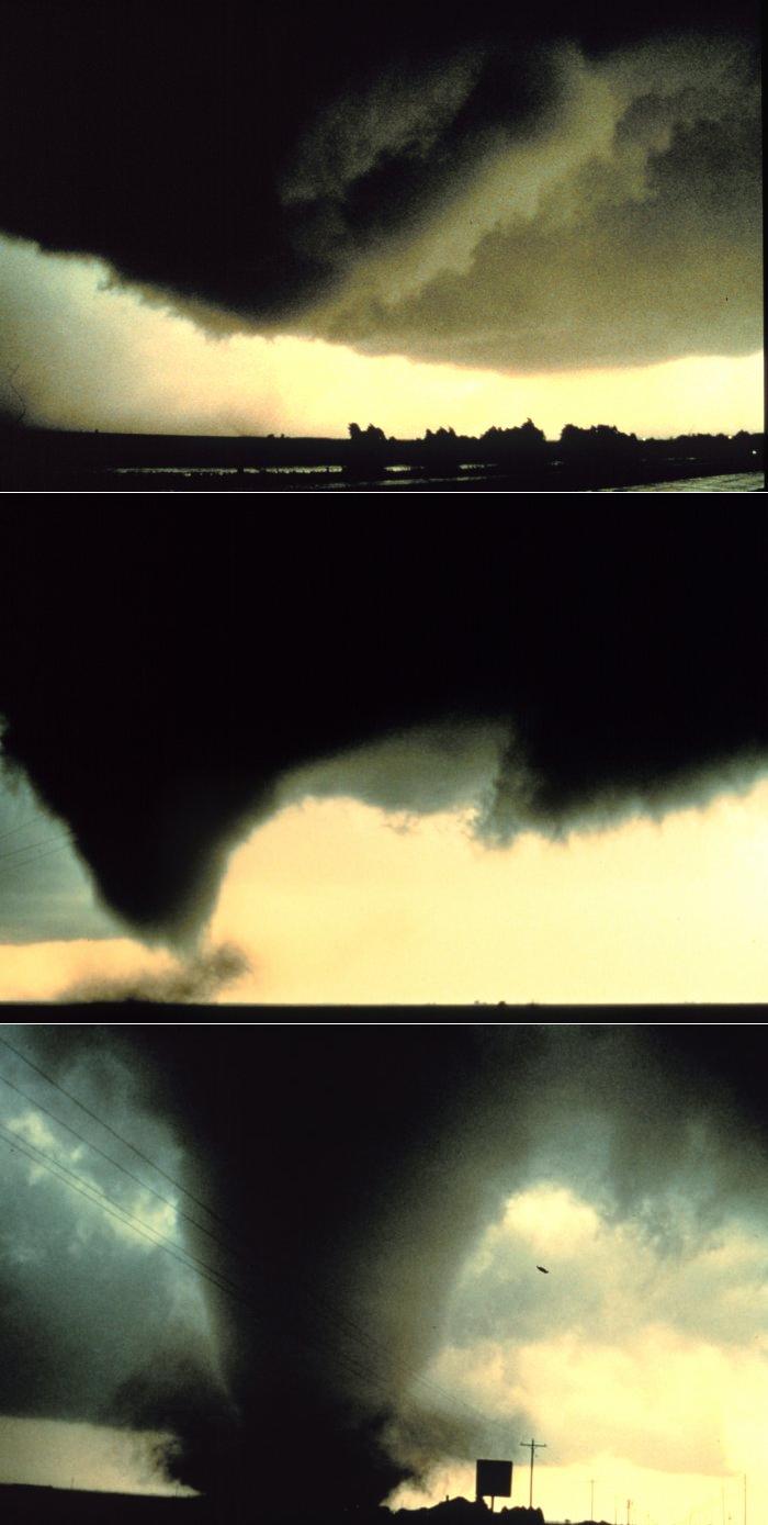
 A sequence of images showing the birth of a supercellular tornado. First, the rotating cloud base lowers. This lowering becomes a funnel, which continues descending while winds build near the surface, kicking up dust and other debris. Finally, the visible funnel extends to the ground, and the tornado begins causing major damage.
Tornadogenesis is the process by which a tornado forms. There are many types of tornadoes, and each type of tornado can have several different methods of formation. Scientific study is ongoing, as some aspects of tornado formation remain a mystery.
Contents
Supercellular tornadoes
Classical tornadoes are supercellular tornadoes, which have a recognizable pattern of formation.[1] The cycle begins when a strong thunderstorm develops a rotating mesocyclone a few miles up in the atmosphere. As rainfall in the storm increases, it drags with it an area of quickly descending air known as the rear flank downdraft (RFD). This downdraft accelerates as it approaches the ground, and drags the rotating mesocyclone towards the ground with it. Storm relative helicity (SRH) has been shown to play a role in tornado development and strength. SRH is horizontal vorticity that is parallel to the Inflow of the storm and is tilted upwards when it is taken up by the updraft, thus creating vertical vorticity.
As the mesocyclone lowers below the cloud base, it begins to take in cool, moist air from the downdraft region of the storm. This convergence of warm air in the updraft, and this cool air, causes a rotating wall cloud to form. The RFD also focuses the mesocyclone's base, causing it to siphon air from a smaller and smaller area on the ground. As the updraft intensifies, it creates an area of low pressure at the surface. This pulls the focused mesocyclone down, in the form of a visible condensation funnel. As the funnel descends, the RFD also reaches the ground, creating a gust front that can cause severe damage a good distance from the tornado. Usually, the funnel cloud begins causing damage on the ground (becoming a tornado) within a few minutes of the RFD reaching the ground.
Landspouts
Landspouts are tornadoes which form from an entirely different process. They are similar to waterspouts in appearance and structure, analogous to a fair weather waterspout over land. Known officially as "dust-tube tornadoes" by the National Weather Service, they are thought to form in a manner similar to that of weaker waterspouts. They form during the growth stage of convective clouds by the ingestion and tightening of boundary layer vorticity by the cumuliform tower's updraft.
Waterspouts
Waterspouts are defined as tornadoes over water. However, while some waterspouts are supercellular (also known as "tornadic waterspouts"), forming in a process similar to the one above, most are much weaker and caused by different processes of atmospheric dynamics. They normally develop in moisture-laden environments with little vertical wind shear in areas where wind comes together (convergence), such as land breezes, lake effect bands, lines of frictional convergence from nearby landmasses, or surface troughs. Waterspouts normally develop as their parent clouds are in the process of development. It is theorized that they spin upward as they move up the surface boundary from the horizonal shear near the surface, and then stretch upward to the cloud once the low level shear vortex aligns with a developing cumulus or thunderstorm.[2] Their parent cloud can be as innocuous as a moderate cumulus, or as significant as a supercell.
Continuing research
Though these are widely-accepted hypotheses for how most tornadoes form, they do not explain the formation of long-lived tornadoes, or tornadoes with multiple vortices. These each have different mechanisms which influence their development—however, most tornadoes follow a pattern similar to these ones.[3] There are still many things about the formation of tornadoes which remain a mystery.[4] Research programs, including VORTEX, deployment of TOTO (the TOtable Tornado Observatory), and dozens of other programs, hope to solve many questions that still plague meteorologists about this topic.[5]
See also
References
- ^ Doswell, Moller, Anderson et al. (2005). "Advanced Spotters' Field Guide" (PDF). US Department of Commerce. http://www.weather.gov/os/brochures/adv_spotters.pdf. Retrieved 2006-09-20.
- ^ Barry K. Choy and Scott M. Spratt. Using the WSR-88D to Predict East Central Florida Waterspouts. Retrieved on 2006-10-25.
- ^ Markowski, Paul M.; Jerry M. Straka and Erik N. Rasmussen (March 2003). "Tornadogenesis Resulting from the Transport of Circulation by a Downdraft: Idealized Numerical Simulations". Journal of the Atmospheric Sciences (American Meteorological Society) 60 (6): 795–823. Bibcode 2003JAtS...60..795M. doi:10.1175/1520-0469(2003)060<0795:TRFTTO>2.0.CO;2. ISSN 1520-0469. http://ams.allenpress.com/amsonline/?request=get-document&doi=10.1175%2F1520-0469(2003)060%3C0795:TRFTTO%3E2.0.CO%3B2.
- ^ "VORTEX: Unraveling the Secrets." National Severe Storms Laboratory.
- ^ Rasmussen, Erik (31 December 2000). "Tornado Forecasting". http://cimms.ou.edu/~erik/Tornadoes/Forecasting/Detailed/Detailed.htm. Retrieved 2000-11-04.[dead link]
External links
- Tornadogenesis in Supercells: The Three Main Ingredients (NWS)
- Forecasters Focus on Strange Tornado Source - Atmospheric gravity waves can spin up tornadoes in thunderstorms, LiveScience.com, 20 March 2008
Categories:
Wikimedia Foundation. 2010.