- Tuamotus
-
Tuamotus Native name: Tuamotu 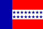
Flag of the Tuamotu Islands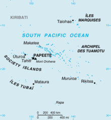
Geography Location Pacific Ocean Archipelago Polynesia Total islands 78 Major islands Anaa, Fakarava, Hao, Makemo Area 850 km2 (328 sq mi) Country FranceOverseas collectivity French Polynesia Demographics Population 15,862 (as of 2002) Density 18 /km2 (47 /sq mi) The Tuamotus or the Tuamotu Archipelago (French: Îles Tuamotu, officially Archipel des Tuamotu) are a chain of islands and atolls in French Polynesia. They form the largest chain of atolls in the world, spanning an area of the Pacific Ocean roughly the size of Western Europe. The Tuamotu islands were originally settled by Polynesians who share a common culture and language.
Contents
Administrative divisions
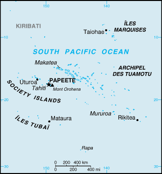
 Map of Tuamotus.
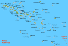
 Satellite image of Tuamotus.
French Polynesia is a semi-autonomous island group designated as an overseas country of France. The Tuamotus combine with the Gambier Islands to form the Îles Tuamotu-Gambier which is one of the five administrative divisions of French Polynesia.
The Tuamotus are grouped into sixteen communes: Anaa; Arutua; Fakarava; Fangatau; Hao; Hikueru; Makemo; Manihi; Napuka; Nukutavake; Pukapuka; Rangiroa; Reao; Takaroa; Tatakoto; and Tureia.
Electoral divisions
 Pearl farm in the Tuamotus.
The communes on Tuamotu are part of two different electoral districts (circonscriptions électorales) represented in the Assembly of French Polynesia. The Îles Gambier et Tuamotu Est electoral district comprises the commune of Gambier and eleven communes in eastern Tuamotu: Anaa; Fangatau; Hao; Hikueru; Makemo; Napuka; Nukutavake; Pukapuka; Reao; Tatakoto; and Tureia. The other five communes in western Tuamotu – Arutua; Fakarava; Manihi; Rangiroa; and Takaroa – form the Îles Tuamotu Ouest electoral district .
Demography
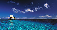
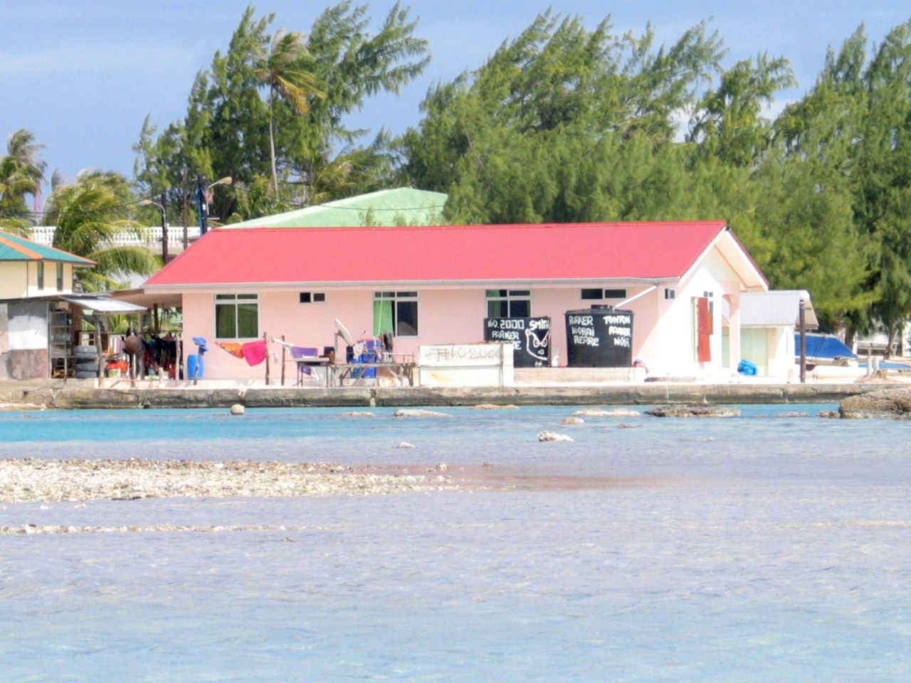
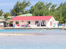 Typical waterside view in the Tuamotus.
At the 2007 census, the Tuamotus (including the Gambier Islands) had a population of 18,317 inhabitants (15,862 in 2002, 8,100 in 1983). Of these, 769 inhabitants live in a 215-nautical-mile (400 km; 250 mi) radius around Moruroa and Fangataufa, the sites of French nuclear tests.
The common language spoken in the Tuamotus is Tuamotuan, except in Puka-Puka which uses the Marquesan language. The Gambier Islands use Mangarevan.
Economy
The islands' economy is predominantly composed of subsistence agriculture. The most important sources of additional income are the cultivation of black pearls and the preparation of copra. Tourism-related income remains meager, especially by comparison to the tourism industry of the neighboring Society Islands. A modest tourism infrastructure is found on the atolls of Rangiroa and Manihi which have recreational scuba diving and snorkeling destinations.
Geography
Despite the vast spread of the archipelago, it covers a total land area of only about 885 km² (345 sq mi). The climate is warm tropical, without pronounced seasons. The annual average temperature is a relatively continuous 26°C (79°F). Water sources such as lakes or rivers are absent, leaving catchments of rain as the only source of fresh water . The annual average rainfall is 1400 mm (about 55 in). Rainfall is not markedly different throughout the year, although it is lowest during the months of September and November.
Geological stability of the archipelago is high, as it was created by the weakly active Easter Fracture Zone. No volcanic eruptions have been recorded historically.
Flora and fauna
The sparse soil of the coral islands does not permit a diverse vegetation. The coconut palm, which forms the basis for copra production, is of special economic importance. On a few islands, vanilla is also cultivated. Agriculture is generally otherwise limited to simple subsistence. Fruit and vegetable staples include yams, taro, and breadfruit, as well as a wide range of other tropical fruits. Pandanus leaves are traditionally woven together as roof thatch (although nowadays there are a great number of corrugated sheet-metal roofs instead), as well as for other items, such as mats and hats.
The species-rich reefs are home to a diverse range of underwater fauna. Surface creatures are primarily seabirds, insects, and lizards. The Tuamotus have only 57 species of birds, but ten of these are endemic, including the Tuamotu Kingfisher, the Tuamotu Reed-warbler, and the Tuamotu Sandpiper. Thirteen species are globally threatened and one is extinct.[1]
Geology
All of the islands of the Tuamotus are coral "low islands": essentially high sand bars built upon coral reefs. Makatea, southwest of the Palliser Islands, is one of three great phosphate rocks in the Pacific Ocean. The others are Banaba in Kiribati, and the island nation of Nauru. Although geographically part of the Tuamotus, the Gambier Islands, at the southeastern extreme of the archipelago, are geologically and culturally distinct.
In the northwest of the archipelago, the ring-shaped atoll Taiaro provides a rare example of a coral reef with a fully enclosed lagoon. The atoll was officially designated as a UNESCO biosphere reserve in 1977.[2]
History
The early history of the Tuamotu islands is generally shrouded in mystery. Archaeological findings lead to the conclusion that the western Tuamotus were settled from the Society Islands by c. 700. On the islands of Rangiroa, Manihi and Mataiva, there are flat ceremonial platforms (called marae) made of coral blocks, although their exact age is unknown.
Tupac Inca Yupanqui from the Inca Empire is credited with leading a circa 10 month-long voyage of exploration into the Pacific around 1480.[3]
European encounters with the Tuamotus began with that of Ferdinand Magellan, during his circumglobal voyage in 1521. His visit was followed by:
- Portuguese sailor Pedro Fernandes de Queirós in 1606;
- Dutch mariners Willem Schouten and Jacob Le Maire in 1616;
- Jakob Roggeveen (who also first sighted Easter Island) in 1722;
- John Byron in 1765;
- Louis Antoine de Bougainville in 1768;
- James Cook during his first voyage in 1769;
- Domingo de Bonechea in 1774 and
- German navigator Otto von Kotzebue, sailing in the service of the Russian tsars, in 1815.
None of these visits was of political consequence, as the islands were in the sphere of influence of the Pomare dynasty of Tahiti.
It was not until the beginning of the 19th century that the first Christian missionaries arrived. Traders took the islands' pearls to the European markets by the late 19th century, making them coveted possessions. France forced the abdication of King Pomare V of Tahiti and claimed the islands without ever having formally annexed them.
Robert Louis Stevenson and Fanny Vandegrift Stevenson travelled among the Paumotus on the Yacht Casco in 1888; an account of their journey was published as In the South Seas.[4] Jack London wrote a story, "The Seed of McCoy," based on an incident in 1900 when a burning ship, the Pyrenees, was safely beached on Mangareva. In the story, London has the ship sail past Mangareva and all through the Tuamotus before beaching on Fakarava.[5]
The Tuamotus made headlines around the world in 1947, when archaeologist Thor Heyerdahl, sailing from South America, reached Raroia on his raft Kon-Tiki. More recently the islands have been the subject of headlines as the site of French nuclear weapons testing on the atolls of Moruroa and Fangataufa.
Island groups
The Tuamotu archipelago encompasses seven small groups of islands and atolls:
Disappointment Islands
- Puka-Puka
- Napuka
- Tepoto (North) (Tepoto Nord)
Duke of Gloucester Islands
Far East Tuamotu Group
Related island groups include:
- The Gambier Group: Akamaru; Angakauitai; Aukena; Kamaka; Kouaku; Makapu; Makaroa; Mangareva; Manui; Mekiro; Papuri; Puaumu; Taravai; Tokorua; and Totengengie.
- The Outer Gambier Group: Marutea Sud; Maria Est; Morane; and Temoe.
- The Acteon Group: Matureivavao; Tenararo; Tenarunga; and Vahanga.
See also
- French overseas departments and territories
- Islands controlled by France in the Indian and Pacific oceans
References
- ^ Blanvillain, C; Florent, C & V. Thenot (2002) "Land birds of Tuamotu Archipelago, Polynesia: relative abundance and changes during the 20th century with particular reference to the critically endangered Polynesian ground-dove (Gallicolumba erythroptera)". Biological Conservation 103 (2): 139-149 doi:10.1016/S0006-3207(01)00112-4
- ^ "Biosphere Reserve Information". Unesco.com. 2008. http://www.unesco.org/mabdb/br/brdir/directory/biores.asp?code=FRA+01&mode=all. Retrieved 11 November 2011.
- ^ José Antonio del Busto: Tupac Yupanqui, Discoverer of Oceania, Lima 2000
- ^ In the South Seas (1896) & (1900) Chatto & Windus; republished by The Hogarth Press (1987)
- ^ London, Jack (2006). Gary Riedl and Thomas R. Tietze. ed. Jack London's tales of cannibals and headhunters: nine South Seas stories by America's master of adventure. UNM Press. pp. 33-37. ISBN 0826337910. http://books.google.com/books?id=n2obXkYcSPcC. Retrieved 2011-09-28.
External links
- Stevenson, Robert L. (1896), In the South Seas
- Official site (Tahiti Tourism board)
- Official site (Geography)
- Official site (Administration)
- http://earthobservatory.nasa.gov/IOTD/view.php?id=44596
Coordinates: 18°02′27″S 141°24′34″W / 18.04083°S 141.40944°W
 Archipelagos of French Polynesia
 Society Islands (Leeward Islands • Windward Islands)
 Tuamotu Islands
  Gambier Islands
  Austral Islands
  Marquesas Islands
Tuamotus

GambiersIslands/Atolls: Ahe • Ahunui • Akiaki • Amanu • Anaa* • Anuanuraro • Anuanurunga • Apataki • Aratika • Arutua* • Faaite • Fakahina • Fakarava* • Fangatau* • Fangataufa • Hao* • Haraiki • Hereheretue • Hikueru* • Hiti • Katiu • Kauehi • Kaukura • Makatea • Makemo* • Manihi* • Manuhangi • Maria Est • Marokau • Marutea (North) • Marutea (South) • Mataiva • Matureivavao • Morane • Moruroa • Motutunga • Napuka* • Nengonengo • Niau • Nihiru • Nukutavake* • Nukutepipi • Paraoa • Pinaki • Puka Puka* • Pukaruha • Rangiroa* • Raraka • Raroia • Ravahere • Reao* • Reitoru • Rekareka • Taenga • Tahanea • Taiaro • Takapoto • Takaroa* • Takume • Tatakoto* • Tauere • Tekokota • Tematangi • Temoe • Tenararo • Tenarunga • Tepoto (North) • Tepoto (South) • Tikehau • Tikei • Toau • Tuanake • Tureia* • Vahanga • Vahitahi • Vairaatea • Vanavana * commune administration centerIsland groups: Acteon • Disappointment • Duke of Gloucester • King George • Two Groups • Palliser • Raeffksy
Polynesia Polynesian triangle Austral Islands · Cook Islands · Easter Island · Gambier Islands · Hawaiian Islands · Marquesas · New Zealand · Pitcairn Islands · Sala y Gómez · Samoan Islands · Society Islands · Tokelau · Tonga · Tuamotus · Tuvalu · Wallis and Futuna IslandsPolynesian outliers Anuta · Emae · Futuna · Kapingamarangi · Loyalty Islands · Mele · Nuguria · Nukumanu · Nukuoro · Ontong Java · Ouvéa · Pileni · Rennell · Sikaiana · Takuu · TikopiaPolynesian-influenced Categories:


Wikimedia Foundation. 2010.