- Desford
-
Coordinates: 52°37′30″N 1°17′42″W / 52.625°N 1.295°W
Desford 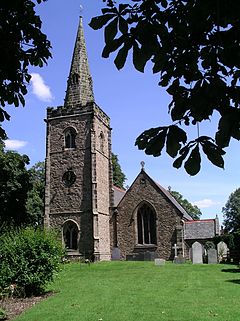
St. Martin's parish church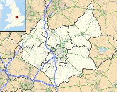
 Desford
Desford shown within LeicestershirePopulation 3,676 (2001 census)[1] OS grid reference SK4703 Parish Desford District Hinckley and Bosworth Shire county Leicestershire Region East Midlands Country England Sovereign state United Kingdom Post town Leicester Postcode district LE9 Dialling code 01455 Police Leicestershire Fire Leicestershire Ambulance East Midlands EU Parliament East Midlands UK Parliament Bosworth Website Desford parish council List of places: UK • England • Leicestershire Desford is a village and civil parish in the North West Leicestershire district, 7 miles (11 km) west of the centre of Leicester. The parish includes the hamlets of Botcheston and Newtown Unthank and a scattered settlement at Lindridge.
Contents
Manors
At Lindridge about 1 mile (2 km) north of the village is a rectangular moat up to 13 yards (12 m) wide enclosing an area about 115 yards (105 m) by 127 yards (116 m).[2] In the 19th century it was temporarily drained and six early 14th century pottery vessels were found.[2] A building such as a manor house is likely to have stood on the island created by the moat. The moat is a scheduled monument.[2]
There are records of a manor at Desford from at least the 15th century.
The Old Hall or Old Manor House in Desford High Street is a gable-roofed building with an irregular front of four bays,[3] dating from about 1600[4] or a few years thereafter.[3] It is built of brick in English bond with stone quoins[4] and has a timber frame.[3] The house has a two-storeyed porch[4] whose upper storey is jettied.[3] Attached to the house is an early 18th century service wing built of brick in Flemish bond.[3] The Manor House and its attached buildings are Grade II* listed buildings.[3]
Churches
The Church of England parish church of Saint Martin has a Norman font[5] but the present building appears to be late 13th century.[6] The chancel includes two lancet windows.[5] There is a south aisle with an arcade that seems to be late 13th century.[5] The west tower and spire are Perpendicular Gothic[5] and therefore later: a window in the tower west wall is 14th century.[6] The architect Stockdale Harrison of Leicester restored St. Martin's in 1884.[6] The tower has a ring of six bells, all cast by John Taylor & Co of Loughborough in 1912.[7] St. Martin's is a Grade II* listed building.[6]
St. Martin's parish[8] is part of an united benefice with St. Mary Magdalene, Peckleton.[9]
Desford has a free church, which is a member of the Baptist Union of Great Britain.[10]
Economic history
Desford's common lands were enclosed by Act of Parliament in 1759.[11]
The Leicester and Swannington Railway was built through the parish in 1832. It passes within 0.6 miles (1 km) of the village and Desford railway station was built at Newtown Unthank to serve the parish. The Midland Railway took over the line in 1845 and had extended it to Burton-on-Trent by 1848. British Railways withdrew passenger services in 1964 and today the Leicester to Burton upon Trent Line carries only goods traffic.
Caterpillar Inc. is now a significant employer in the parish (see below).
Aerodrome
South of the village, Reid and Sigrist had created Desford Aerodrome on Carts Field plus land in the adjoining Peckleton parish by 1936. It was a flying training school, with George E. Lowdell as its Chief flying Instructor. The majority of aeroplanes used were De Havilland Tiger Moth single engined biplanes. An early form of flight simulator was also used and was visible from the public road. Leicester Aero Club used the aerodrome until it moved to nearby Ratcliffe Aerodrome. Early in 1939 Lowdell flew the first flight of the New Malden-built Reid and Sigrist R.S.1 Snargasher from Desford.
The aerodrome has been redeveloped as an industrial site where Caterpillar Inc. now has a large factory.
Amenities
The parish has six public houses: the Blue Bell,[12] Bull's Head, Lancaster Arms[13] and White Horse in Desford, the Greyhound[14] in Botcheston and the Red Lion at Lindridge.
Desford has a community primary school[15] and a secondary school, Bosworth Community College.[16]
Desford has a post office, a public library[17] and a sports club. Tropical Birdland, a visitor attraction exhibiting many bird species, is at Desford.
References
- ^ "Area selected: Hinckley and Bosworth (Non-Metropolitan District)". Neighbourhood Statistics: Full Dataset View. Office for National Statistics. http://neighbourhood.statistics.gov.uk/dissemination/viewFullDataset.do?instanceSelection=03070&productId=779&$ph=60_61&datasetInstanceId=3070&startColumn=1&numberOfColumns=4&containerAreaId=790451. Retrieved 21 July 2011.
- ^ a b c "Moat site 440m south west of Lindridge Fields Farm". The National Heritage List for England. English Heritage. http://list.english-heritage.org.uk/resultsingle.aspx?uid=1017053. Retrieved 21 July 2011.
- ^ a b c d e f "Attached barn and service block Old Manor House". The National Heritage List for England. English Heritage. http://list.english-heritage.org.uk/resultsingle.aspx?uid=1074078. Retrieved 21 July 2011.
- ^ a b c Pevsner, 1960, page 95
- ^ a b c d Pevsner, 1960, page 94
- ^ a b c d "Church of St Martin". The National Heritage List for England. English Heritage. http://list.english-heritage.org.uk/resultsingle.aspx?uid=1361378. Retrieved 21 July 2011.
- ^ Dawson, George (8 October 2010). "Desford S Martin". Dove's Guide for Church Bell Ringers. http://dove.cccbr.org.uk/detail.php?searchString=Desford&DoveID=DESFORD. Retrieved 21 July 2011.
- ^ St Martin's Church Desford
- ^ Archbishops' Council (2010). "St Martins Desford, Desford". A Church Near You. Church of England. http://www.achurchnearyou.com/desford-st-martin/. Retrieved 21 July 2011.
- ^ Desford Free Church
- ^ Journal of the House of Lords: 1756–60 29: 496–509. 2 May 1759. http://www.british-history.ac.uk/report.aspx?compid=114467. Retrieved 21 July 2011.
- ^ Everards: The Blue Bell
- ^ Everards: The Lancaster Arms
- ^ The Greyhound, Botcheston
- ^ Desford Community Primary School
- ^ Bosworth Community College
- ^ "Desford Library". Libraries in Hinckley and Bosworth District. Leicestershire County Council. 4 February 2011. http://www.leics.gov.uk/desford_library.htm. Retrieved 21 July 2011.
Sources and further reading
- Hoskins, W.G. (1972) [1950]. The Heritage of Leicestershire. Leicester: City of Leicester Publicity Department. p. 16.
- Pevsner, Nikolaus (1960). Leicestershire and Rutland. The Buildings of England. Harmondsworth: Penguin Books. pp. 94–95.
External links
- Tropical Birdland
- Map sources for Desford
Categories:- Villages in Leicestershire
- Civil parishes in Leicestershire


Wikimedia Foundation. 2010.