- M-137 (Michigan highway)
-
"M137" redirects here. For Mercedes-Benz engine, see Mercedes-Benz M137 engine.
M-137
M-137 highlighted in redRoute information Maintained by MDOT Length: 2.890 mi[2] (4.65 km) Existed: 1929[1] – present Major junctions South end: Interlochen State Park North end:  US 31 in Interlochen
Location Counties: Grand Traverse Highway system Michigan State Trunkline Highway System
Interstate • US • State←  M-136
M-136M-138  →
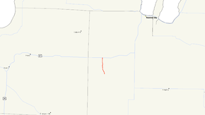
→M-137 is a state trunkline highway in the US state of Michigan that serves as a spur route to the Interlochen Center for the Arts and Interlochen State Park. It starts at US Highway 31 (US 31) in Grand Traverse County and terminates at the park 2.890 miles (4.651 km) away. Although M-137 is near the much longer M-37 designation, the two have never been related to one another. M-37 in the area was a section of M-42 at the time M-137 was designated.
Contents
Route description
M-137 starts at the Interlochen State Park south of the community of Interlochen. Farther south, the road is known as Grand Traverse County Road 137 (CR 137). It runs north, connecting the Interlochen Center for the Arts and Interlochen State Park and the with the rest of the state trunkline system at US 31 at Interlochen corners. The entire route is two-lane rural highway, winding through wooded terrain between Green and Duck lakes. The roadway continues north of US 31 as South Long Lake Road after the M-137 designation ends.[2][3]
History
The early history of M-137 shows some confusion. Two new trunklines were added to the state system on December 2, 1929, one in the Upper Peninsula is initially shown on maps as M-137, one in the Lower Peninsula is not given a designation. The 1931 state official map shows that the UP routing in Schoolcraft County is given the M-99 designation and M-137 is applied as the connector route to the Interlochen State Park. This routing was extended on August 17, 1931 by 0.9 miles (1.4 km). The route was realigned and completed on March 6, 1956, moving M-137 off the campus of the Interlochen Center for the Arts.[1]
Major intersections
The entire highway is in Grand Traverse County.
Location Mile[2] Destinations Notes Interlochen 0.000 Interlochen State Park Main Gate Roadway continues south as CR 137 Green Lake Township 2.890 US 31 – Muskegon, Traverse CityRoadway continues north as South Long Lake Road 1.000 mi = 1.609 km; 1.000 km = 0.621 mi References
- ^ a b Bessert, Christopher J. (April 23, 2006). "Michigan Highways: Highways 120 through 139". Michigan Highways. http://www.michiganhighways.org/listings/MichHwys120-139.html#M-137. Retrieved November 2, 2006.
- ^ a b c Michigan Department of Transportation (2001). Control Section/Physical Reference Atlas (Map). http://mdotwas1.mdot.state.mi.us/public/maps/pr/. Retrieved August 5, 2008.
- ^ Google, Inc. Google Maps – Overview Map of M-137 (Map). Cartography by Google, Inc. http://maps.google.com/maps?f=q&source=s_q&hl=en&geocode=&q=Interlochen,+MI&sll=37.0625,-95.677068&sspn=64.497063,65.654297&ie=UTF8&hq=&hnear=Interlochen,+Grand+Traverse,+Michigan&ll=44.639101,-85.769234&spn=0.057775,0.064116&z=14. Retrieved March 25, 2010.
External links
Categories:- State highways in Michigan


Wikimedia Foundation. 2010.