- Nyagan
-
Nyagan (English)
Нягань (Russian)- Town[citation needed] - 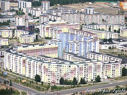
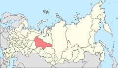
Location of Khanty-Mansi Autonomous Okrug in Russia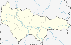
 NyaganLocation of Nyagan in Khanty-Mansi Autonomous Okrug
Coordinates: 62°08′N 65°23′E / 62.133°N 65.383°ECoordinates: 62°08′N 65°23′E / 62.133°N 65.383°E 
Coat of arms Administrative status Country Russia Federal subject Khanty–Mansi Autonomous Okrug Statistics Population (2010 Census,
preliminary)54,903 inhabitants[1] - Rank in 2010 302nd Population (2002 Census) 52,610 inhabitants[2] - Rank in 2002 312th Time zone [3] Nyagan (Russian: Нягань) is a town in the northwestern part of Khanty–Mansi Autonomous Okrug, Russia, situated near the Ob River and 230 kilometers (140 mi) northwest of Khanty-Mansiysk. It is named after the Nyagan-Yugan River, a tributary of the Ob River. Population: 54,903 (2010 Census preliminary results);[1] 52,610 (2002 Census);[2] 54,061 (1989 Census).[4]
Contents
Economy and history
Nyagan is one of the youngest towns in Western Siberia. It was established in 1965 as a forestry center; it is now principally a center of the petroleum and natural gas industries, and was originally named Nyakh (Нях). This toponym appeared on maps in the same year, but the town was renamed on August 15, 1985. The town territory is a waterlogged area, and the region is notable for sudden temperature drops. The railway from Yekaterinburg to the Ob region has passed though Nyagan since April 2, 1967. Nyagan Airport, which opened in 1993, handles the Russian Antonov An-24, Yakovlev Yak-40, and Tupolev Tu-134 aircraft. On September 1, 2000 a regional museum opened.
Notable people
- Birthplace of Maria Sharapova, tennis player
References
- ^ a b Федеральная служба государственной статистики (Federal State Statistics Service) (2011). "Предварительные итоги Всероссийской переписи населения 2010 года (Preliminary results of the 2010 All-Russian Population Census)" (in Russian). Всероссийская перепись населения 2010 года (All-Russia Population Census of 2010). Federal State Statistics Service. http://www.perepis-2010.ru/results_of_the_census/results-inform.php. Retrieved 2011-04-25.
- ^ a b Федеральная служба государственной статистики (Federal State Statistics Service) (2004-05-21). "Численность населения России, субъектов Российской Федерации в составе федеральных округов, районов, городских поселений, сельских населённых пунктов – районных центров и сельских населённых пунктов с населением 3 тысячи и более человек (Population of Russia, its federal districts, federal subjects, districts, urban localities, rural localities—administrative centers, and rural localities with population of over 3,000)" (in Russian). Всероссийская перепись населения 2002 года (All-Russia Population Census of 2002). Federal State Statistics Service. http://www.perepis2002.ru/ct/doc/1_TOM_01_04.xls. Retrieved 2010-03-23.
- ^ Правительство Российской Федерации. Постановление №725 от 31 августа 2011 г. «О составе территорий, образующих каждую часовую зону, и порядке исчисления времени в часовых зонах, а также о признании утратившими силу отдельных Постановлений Правительства Российской Федерации». Вступил в силу по истечении 7 дней после дня официального опубликования. Опубликован: "Российская Газета", №197, 6 сентября 2011 г. (Government of the Russian Federation. Resolution #725 of August 31, 2011 On the Composition of the Territories Included into Each Time Zone and on the Procedures of Timekeeping in the Time Zones, as Well as on Abrogation of Several Resolutions of the Government of the Russian Federation. Effective as of after 7 days following the day of the official publication).
- ^ "Всесоюзная перепись населения 1989 г. Численность наличного населения союзных и автономных республик, автономных областей и округов, краёв, областей, районов, городских поселений и сёл-райцентров. (All Union Population Census of 1989. Present population of union and autonomous republics, autonomous oblasts and okrugs, krais, oblasts, districts, urban settlements, and villages serving as district administrative centers.)" (in Russian). Всесоюзная перепись населения 1989 года (All-Union Population Census of 1989). Demoscope Weekly (website of the Institute of Demographics of the State University—Higher School of Economics. 1989. http://demoscope.ru/weekly/ssp/rus89_reg.php. Retrieved 2010-03-23.
External links
- Official website of Nyagan (Russian)
Cities and towns in Khanty-Mansi Autonomous Okrug Administrative center: Khanty-Mansiysk Beloyarsky · Kogalym · Langepas · Lyantor · Megion · Nefteyugansk · Nizhnevartovsk · Nyagan · Pokachi · Pyt-Yakh · Raduzhny · Sovetsky · Surgut · Uray · Yugorsk
 Categories:
- Cities and towns in Khanty-Mansi Autonomous Okrug
- Cities and towns built in the Soviet Union
- Populated places established in 1965


Wikimedia Foundation. 2010.