- Sprogø
Sprogø is a small, protected Danish
island , which is located in theGreat Belt , thestrait that separates the main islands ofFunen andZealand . It lies about halfway across the strait, 6.7 km from the Zealand shore and 8 km from the Funen shore.Today, the island forms part of the
Great Belt fixed link , and is connected to Funen by a road and rail bridge, and to Zealand by both a roadsuspension bridge and twin railtunnel s. The island is crossed when using the link. During the construction, the island was drastically remodelled, withland reclamation increasing its area from 38 to 154hectares .There are remains of buildings on the original part of Sprogø from the beginning of the 12th century, a fortress built under king Valdemar the Great. During construction work, extensive archaeological investigations were undertaken, and among other findings it was revealed that the first inhabitants arrived more than 8,000 years ago.
The island has no permanent population today, but is used by "Sund og Bælt", the company that owns and operates the bridges. It is also a
nature reserve , and tours of the island are organised.Location map many
DenmarkCIAx
Alternative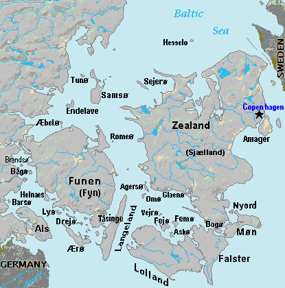
caption = Sprogø island (map center) is west ofZealand island, east ofFunen , NW ofAgersø island, between main townsNyborg &Korsør . Road/rail bridges join Knudshaved to Sprogø, with bridge and rail tunnels to Halsskov.
mark = Circle sheer red 33.gif| marksize=33
lat=55.68 | long=11.18
label2 = Nyborg
mark2=Blue_pog.svg
pos2=left | bg2=#EEEEEE
lat2=55.58 | long2=10.85 | mark2size=6
label3 =
mark3=Blue_pog.svg
lat3=55.55 | long3=10.94 | mark3size=6 | mark3high=6
label4 = Knudshaved
pos4=bottom | bg4=yellow | label4_size=77
lat4=55.36 | long4=10.11 | mark4size=1
label5 = Halsskov
mark5=Blue_pog.svg
pos5=right | bg5=yellow | label5_size=77
lat5=55.68 | long5=11.50 | mark5size=6
label6 =
mark6=Blue_pog.svg
lat6=55.60 | long6=11.56 | mark6size=6 | mark6high=6
label7 = Korsør
pos7=right | bg7=#EEEEEE
lat7=55.49 | long7=11.63 | mark7size=1
label8 = Funen
pos8=bottom | bg8= | label8_size=104
lat8=56.07 | long8=9.43 | mark8size=1
float=left | width=290A darker part of the island's history are the years between 1923 and 1959, when the island was used for containment of women deemed pathologically promiscuous, the main concern being unwanted pregnancies. At the time it was considered a very humane approach, given the fact that they had previously been confined.
The lighthouse, which can be seen in the picture, was built by the mail service in 1868, replacing an older structure from 1809. It was built on the foundations of the 12th century fortress.
External links
* [http://www.sundogbaeltfoto.dk/search/categories.php?search=23 Sund & Bælt Photo Archive: Sprogø island] – construction photos including aerial shots of Sprogø in its original form (log in using the default username and password)
* [http://www.sitecenter.dk/erik-vpedersen/sprog/ Sprogø, -øen i midten] Da icon – History of Sprogø; many images of the island
* [http://www.fyrtaarne.dk/sprogoe.html Sprogø fyr] Da icon – about Sprogø lighthouse; many photographs
Wikimedia Foundation. 2010.