- Mount Gambier, South Australia
-
For the nearby maar volcano, see Mount Gambier (volcano).
Mount Gambier
South Australia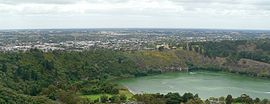
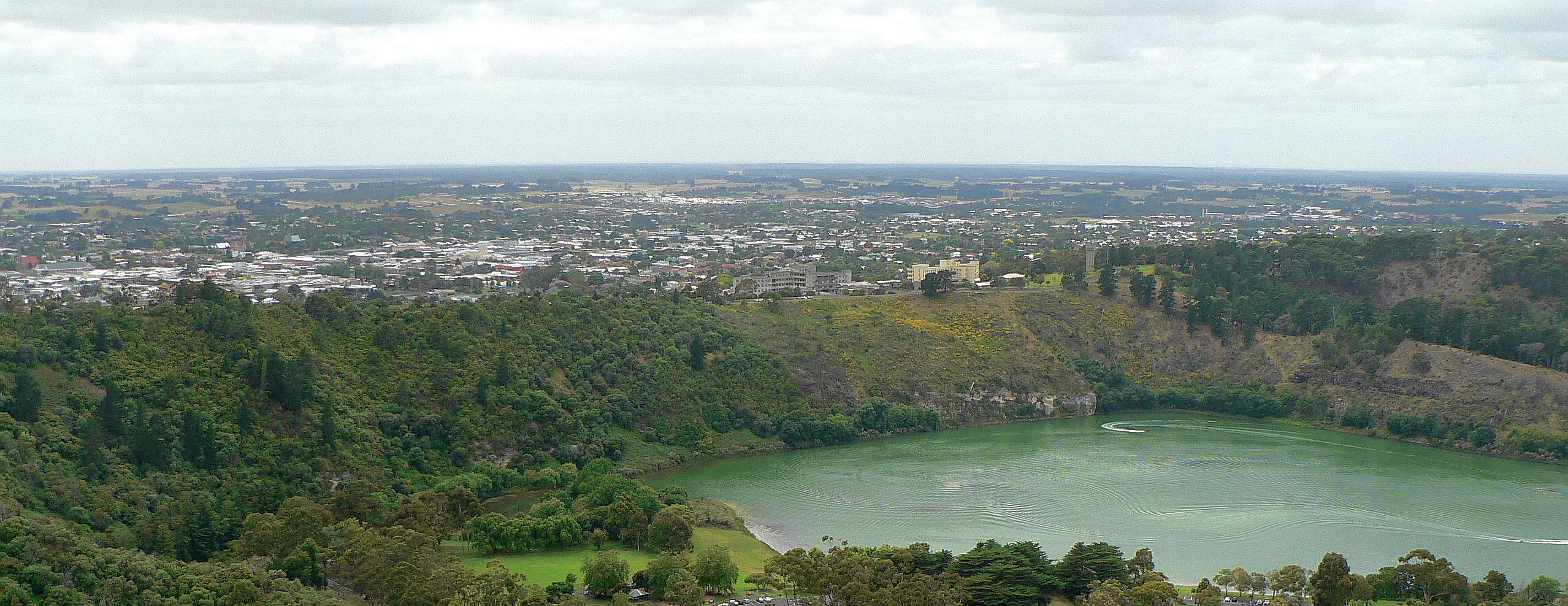
View across Valley Lake and Marist Park to Mount Gambier's urban area from Centenary Tower
 Mount Gambier
Population: 23,494(2006 census)[1] (50th) • Density: 881.1/km² (2,282.0/sq mi) Established: 1854 Postcode: 5290,[2] 5291 [3] Coordinates: 37°49′46″S 140°46′58″E / 37.82944°S 140.78278°E Area: 26.7 km² (10.3 sq mi) Time zone: • Summer (DST)
ACST (UTC+9:30) ACDT (UTC+10:30)
Location: LGA: State District: Mount Gambier Federal Division: Barker Mean max temp Mean min temp Annual rainfall 18.9 °C
66 °F8.1 °C
47 °F708.3 mm
27.9 inMount Gambier is the largest regional city in South Australia located approximately 450 kilometres south of the capital Adelaide and just 17 kilometres from the Victorian border.
It takes its name from the Mount Gambier, a crater sighted in 1800 by Lieutenant James Grant from the survey brig, HMS Lady Nelson, and named for Lord James Gambier, Admiral of the Fleet.
It is known for its interesting geography, particularly its volcanic features and the Blue Lake.
Contents
History
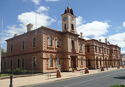 The Old Town Hall was built in 1882.
Before European settlement, the Buandig (or Boandik) people were the original Aboriginal inhabitants of the area. They called it 'ereng balam' or 'egree belum', meaning 'home of the eagle hawk'.[4]
The peak of the extinct Mount Gambier crater was sighted in 1800 by Lieutenant James Grant from the survey brig, HMS Lady Nelson, and named for Lord James Gambier, Admiral of the Fleet.
The Henty brothers who owned large holdings in Portland, Western Victoria claim to the land, were forced to retreat when the lands were granted to Evelyn Sturt, the brother of the explorer Charles Sturt. Industries soon began to appear. The Post Office opened on 22 September 1846,[5] John Byng built the Mount Gambier Hotel in 1847, and Dr Edward Wehl arrived in 1849 to begin a flour-milling operation.
Hastings Cunningham founded "Gambierton" in 1854 by subdividing a block of 77 acres (31 ha). From 1861 to 1878 the Post Office was known by this name before reverting to Mount Gambier. Local government appeared in 1863 when Dr Wehl, who now owned a substantial millhouse on Commercial Road, was elected chairman of the District Council of Mount Gambier. In December 1864 this became the District Council of Mount Gambier West and, at the same time, a separate District Council of Mount Gambier East was formed.
Incorporation in 1876 saw a further division, with the creation of the Town Council and Mr. John Watson elected Mayor. Mount Gambier was governed in this fashion until 1932, when the District Council of East and West merged to form a single District Council of Mount Gambier once more.
On 9 December 1954, Mount Gambier was officially declared a city, and is now widely recognised as having the prestigious title of most important centre in south-east South Australia.[6]
Geography
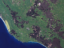 Mount Gambier and region as seen from space
The urban area is located mainly along the northern slopes and plain of a maar volcano of the same name, Mount Gambier. Comprising several craters it is part of the Newer Volcanics Province complex of volcanoes. One of these contains a huge lake of high-quality artesian drinking water which changes colour with the seasons. In winter, it is a steel grey and then changes to a spectacular cobalt blue in the summer, giving rise to its name, Blue Lake. This 70-metre deep lake also accommodates a range of unusual aquatic flora and fauna, in particular fields of large stromatolites. There are several other craters in the city including Valley Lake and Mount Schank and the region has many water-filled caves and sinkholes.
The Mount Gambier urban area extends to suburbs including Suttontown, Mil Lel and Worrolong to the north, Glenburnie to the east, Compton to the west and Moorak and O B Flat to the south.
Demographics
The government in the south-east area of the state, consisting of three local councils, was based around a single administration, many residents of Victoria used to look across the border to Mount Gambier as their centre. Consequently, during the 1970s many elderly locals relocated to Victor Harbor and Moonta, both rural areas but with more resources available to cope with an ageing population. A 1976 study found that less than 10 per cent (around 160 people) of residents aged over 65 had lived in the area for less than 5 years, leading to a lack of specific aged-care facilities.[7]
According to the 2006 Census the population of the Mount Gambier census area was 23,494 people, making it the largest urban area in the state outside of Adelaide, and the 50th largest urban area in Australia. Approximately 51.7% of the population were female, 84.9% were Australian born, over 91.5% of residents were Australian citizens and 1.6% were indigenous.
The most popular industries for employment were Log Sawmilling and Timber Dressing (8%), School Education (4.8%) and Retail Trade (3.8%), while the unemployment rate is approx. 7%. The median weekly household income is A$814 or more per week, compared with $924 in Adelaide. 26.9% of the population identify themselves as being free of religion, a lower 21.5% regard themselves as Catholic.
2007 population estimates have Mount Gambier's population at 23,640, an increase of 146 people or 0.6%.[8]
Climate
Mount Gambier has a temperate climate with warm dry summers and cool wet winters. July is the wettest month with an average of 99.4mm falling on 21 days whilst February normally records the lowest rainfall with an average of 25 mm on an average 8 days. The highest ever temperature recorded in Mount Gambier was 43.6 °C on 16 February 1983 (Ash Wednesday fires) and the lowest ever temperature recorded was -3.9 °C on 20 June 1950 and 2 July 1960.[9]
The town is located within a climatic transition zone between oceanic and Mediterranean climate.
Climate data for Mount Gambier Month Jan Feb Mar Apr May Jun Jul Aug Sep Oct Nov Dec Year Record high °C (°F) 43.6
(110.5)43.6
(110.5)41.3
(106.3)35.0
(95.0)28.5
(83.3)21.6
(70.9)22.4
(72.3)26.6
(79.9)32.2
(90.0)33.3
(91.9)41.2
(106.2)43.3
(109.9)43.6
(110.5)Average high °C (°F) 25.2
(77.4)25.1
(77.2)23.1
(73.6)19.4
(66.9)16.1
(61.0)13.8
(56.8)13.1
(55.6)14.1
(57.4)15.8
(60.4)17.9
(64.2)20.3
(68.5)22.8
(73.0)18.9 Average low °C (°F) 11.1
(52.0)11.6
(52.9)10.5
(50.9)8.7
(47.7)7.3
(45.1)5.8
(42.4)5.2
(41.4)5.5
(41.9)6.3
(43.3)7.1
(44.8)8.3
(46.9)9.9
(49.8)8.1 Record low °C (°F) 1.4
(34.5)2.8
(37.0)0.0
(32.0)−1.8
(28.8)−2.8
(27.0)−3.9
(25.0)−3.9
(25.0)−2.6
(27.3)−3.4
(25.9)−1.6
(29.1)−0.8
(30.6)1.2
(34.2)−3.9
(25.0)Precipitation mm (inches) 26.3
(1.035)25.6
(1.008)35.1
(1.382)54.8
(2.157)70.1
(2.76)83.1
(3.272)99.6
(3.921)94.1
(3.705)73.0
(2.874)61.7
(2.429)46.9
(1.846)38.1
(1.5)708.5
(27.894)Source: [10] Economy
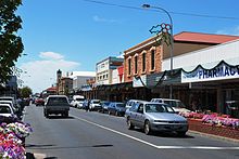 Commercial Street looking east towards the town hall
The town's major industries are agriculture, forestry, trucking and tourism.
Tourism
 Blue Lake, Mount Gambier's No.1 tourist attraction.
Tourism generates around $100 million for the Mount Gambier economy.[11] The city is a major accommodation gateway for the region. Major tourism attractions include the Blue Lake and Valley Lake wildlife park and caves. The region also has many water-filled caves and sinkholes which attract cave divers from around the globe, and such places as Ewens Ponds, Piccaninnie Ponds, Tantanoola Caves, Umpherston Sinkhole, Cave Gardens and Engelbrecht Cave.
Transport
Roads
Mount Gambier sits on a number of highways which connect the city to other major towns in the region, as well as to Adelaide and Melbourne.
- Princes Highway (Jubilee Highway) travels through the city east to west.
- Riddoch Highway (Penola / Bay Road) travels through the city north to south.
Railways
Before conversion of the Melbourne-Adelaide railway to standard gauge in 1995, Mount Gambier was connected to Adelaide on the broad gauge network via Naracoorte, Keith and Tailem Bend. Normal commercial passenger services to Adelaide ceased in 1990, while limited freight services operated until the line was disconnected from the national network.
The Limestone Coast Railway, operated tourist services on the abandoned lines from Mount Gambier to Penola and Coonawarra for a number of years with retired suburban railcars. However due to increased insurance costs they ceased services in 2006.
Airlines
Mount Gambier Airport is located a few kilometres north of the city via the Riddoch Highway. The city is served only by Regional Express, which flies Saab 340 aircraft to Adelaide and Melbourne a number of times a day.
The airport was once the main base of O'Connor Airlines, which also flew to Adelaide and Melbourne. However the company ceased trading in December 2007.
Coaches
Premier Stateliner operates to Mount Gambier from Adelaide. One Daily service operates via Kingstone and Robe, while another Daily service operates via Keith and Naracoorte. Vline operates a daily interstate coach service from Mount Gambier to Warnambool, with an interchange at Warnambool for a rail service to Melbourne.[12]
Education
The town is serviced by five Reception to Year 7 (R-7) Primary schools:
- Reidy Park Primary School;
- Mount Gambier North Primary School;
- McDonald Park;
- Melaleuca Park; and
- Mulga Street Primary School.
There are two Reception to Year 12 (R-12) colleges:
- Tenison Woods College and
- St Martins Lutheran College.
There are two High Schools for Year 8 to 12:
- Mount Gambier High School and
- Grant High School.
- TAFE SA has a campus in Mount Gambier providing an extensive variety of vocational study.
- University of South Australia has a campus in Mount Gambier which offers full-time or part-time undergraduate degrees in Accountancy, Nursing and Social Work.
Notable former residents of Mount Gambier
- Robert Helpmann
- Michele McEachern
- Scott Wilson
Media
Newspapers
The local newspaper for Mount Gambier, the Limestone Coast and South East region of South Australia is The Border Watch. It is published and available in the local area every Tuesday through Friday (with the exception of some public holidays such as Christmas Day). Daily newspapers from Melbourne (Herald Sun and The Age) and Adelaide (The Advertiser) as well as national newspapers such as The Australian and The Australian Financial Review are also available in Mount Gambier and the southeast SA region. Some newspapers from nearby towns such as Millicent and Penola, specialty newspapers like the British International Express weekly newspaper, agricultural newspapers such as The Weekly Times newspaper from Victoria and The South Australian Stock Journal (published by Rural Press) and The Independent Weekly from Adelaide are also available from local newsagents.
Television
- The Australian Broadcasting Corporation (ABC) - ABC1, ABC2, ABC3, ABC News 24 (digital channels)
- The Special Broadcasting Service (SBS) - SBS One, SBS Two (digital channels)
- WIN Television (7, 9 & 10) as SES-8 - SES-8 relays the programming from Seven Network (Seven SA), Nine Network (WIN SA) & Network Ten (Ten SA). WIN Television produces an evening news bulletin combining local, state, national and international news screening Monday to Friday at 6.30pm on the WIN SA channel.[13]
- Austar - Subscription Television service Austar is also available via satellite.
WIN Television broadcasts Nine Network programming, Channel Seven broadcasts Seven Network programming & Channel Ten broadcasts Network Ten programming. The programming schedules for these channels is the same as Channel Nine, Channel Seven and Channel Ten in Adelaide, with local commercials inserted and some variations for coverage of Australian Football League or National Rugby League matches, local and national news and current affairs programs, some lifestyle and light entertainment shows and infomercials.
Due to the close proximity to the Victoria\South Australia state border, most people in Mount Gambier and some adjacent areas of southeast South Australia can receive television services from Western Victoria. These channels broadcast from the Mount Dundas transmitter near the town of Cavendish, Victoria. The transmitter site is located approximately 100 kilometres northeast of Mount Gambier and broadcasts all the television channels from Western Victoria (Prime7 Television (AMV), WIN Television Victoria (VTV), Southern Cross Ten (BCV), the ABC and SBS Victorian services) as well as the new digital free-to-air channels such as ONE, Eleven, GO!, GEM (an acronym of General Entertainment and Movies), 7Two (an acronym of "72") and 7mate that are not currently provided by the local WIN TV station in Mount Gambier, but WIN hope to have these channels up and running by November 2011.
Radio
- ABC
- ABC South East SA (1476 AM)
- ABC Triple J (102.5 FM)
- ABC Radio National (103.3 FM)
- ABC Classic FM (104.1 FM)
- ABC NewsRadio (105.7 FM)
- Commercial
- Radio TAB
- 5SE (963 AM)
- Star FM (96.1 FM)
- 5GTR FM (100.1 FM)
- LIME FM (104.9 FM) (Formerly Rhema FM[14])
Some ABC radio services can also be received from the nearby town of Naracoorte and from Western Victoria.
Sport
Mount Gambier Pioneers
The town has only one national sporting side which is the Mount Gambier Pioneers.The Pioneers entered the South Eastern Basketball League in 1988 and now called the SEABL (South East Australian Basketball League). The Pioneers play at the Icehouse (Mount Gambier Basketball Stadium) which seats over 1,000 people and is also home to the Mount Gambier Basketball Association. The Pioneers have had one championship which occurred in 2003, the side was rated second in the top 5 sides to have ever played in the league by a group of special selectors. In 2011 the current President Dave Bowden, Head Coach Andrew Summerville and Club Captain Dallas Jefree will lead the team into its 24th season in the SEABL, with two new imports Fernandez Lockett and C.J. Webster. The 2011 side will have 9 senior players with 7 development squad members.[15]
The town also has four Australian rules football teams competing in the Western Border Football League: North Gambier, East Gambier, South Gambier and West Gambier.
There is also a range of different sporting leagues and clubs in Mount Gambier and surrounding regions, including soccer, netball, basketball, tennis, hockey, cricket, swimming, cycling, triathlon[16] and golf.[17]
Mount Gambier is the home of "The Alex Roberts 100 Mile Classic", a cycling event that lays claim to the longest continuing open cycling event in South Australia. The event held annually by the Mount Gambier Cycling and Triathlon Club.[16]
The 120m Mount Gambier Gift held annually on the first Saturday in December at Vansittart Oval is the 2nd richest professional footrace in South Australia. Resurrected in 2001 the athletic carnival includes races from 70m to 1600m and attracts athletes from all over Australia, mostly from South Australia and Victoria. Of the ten Mount Gambier athletic carnivals held to date, three Victorians have won the 120 m Gift. On 4 December 2010, the race was won by 20-year-old Wallace Long-Scafidi.[18]
Mount Gambier Gift winners
- 2010 Wallace Long-Scafidi (SA)
- 2009 Shaun Hargreaves (Vic)
- 2008 Aaron Rouge-Serrett (Vic)
- 2007 Dale Woodhams (SA)
- 2006 Keith Sheehy (SA)
- 2005 Keith Sheehy (SA)
- 2004 Andrew Steele (SA)
- 2003 Chris Burckhardt (SA)
- 2002 Matthew Callard (Vic)
- 2001 Shane McKenzie (SA)
Politics
State & Federal
2006 State Election [19] Independent 38.1% Liberal 32.8% Labor 19.6% Family First 4.0% Democrats 2.6% Greens 2.2% 2007 Federal Election [20] Liberal 40.19% Labor 39.62% National 5.85% Family First 5.85% Greens 5.73% Democrats 2.77% Mount Gambier is part of the state electoral district of Mount Gambier, which has been held since 1997 by Independent Minister for Agriculture, Food and Fisheries, Minister for State/Local Government Relations, and Minister for Forests, Rory McEwen. The seat is held by a margin of 12.2%. In federal politics, the city is part of the division of Barker, and has been represented by Liberal MP Patrick Secker since 1998. Barker is held with a margin of 19.10% and is considered safe-liberal. The results shown are from the largest polling station in Mount Gambier — which is located at Mount Gambier High School, on Brownes Road.
Local
The City of Mount Gambier local government area consists of a mayor and ten councillors, elected equally from the East and West wards. As of November 2007[update], the unpopular Mayor of Mount Gambier council is Steve Perryman. The City of Mount Gambier is surrounded by the District Council of Grant local government area.
See also
References
- ^ Australian Bureau of Statistics (25 October 2007). "Mount Gambier (Urban Centre/Locality)". 2006 Census QuickStats. http://www.censusdata.abs.gov.au/ABSNavigation/prenav/LocationSearch?collection=Census&period=2006&areacode=UCL417400&producttype=QuickStats&breadcrumb=PL&action=401. Retrieved 2008-06-25.
- ^ Australia Post - Postcode: Mount Gambier, SA (25 June 2008)
- ^ Australia Post - Postcode: Mount Gambier West, Mount Gambier East, SA (25 June 2008)
- ^ "Other information". Place Names Online. Government of South Australia Land Services Group. Archived from the original on 2007-09-30. http://web.archive.org/web/20070930203301/http://www.placenames.sa.gov.au/pno/other.phtml?recno=SA0025397. Retrieved 2006-10-22.
- ^ Premier Postal History. "Post Office List". https://www.premierpostal.com/cgi-bin/wsProd.sh/Viewpocdwrapper.p?SortBy=VIC&country=. Retrieved 2008-04-11
- ^ smh.com.au - Travel / Mount Gambier(28 June 2008)
- ^ Radford, Anthony J. (1981). "Community Action: A Rural Survey and Its Outcome". In Howe, Anna b.. Towards an older Australia: Readings in Social Gerontology. St Lucia, QLD: University of Queensland Press. pp. 196–204. ISBN 0702215341.
- ^ Australian Bureau of Statistics - Regional Population Growth, Australia, 2006-07 - South Australia (28 July 2008)
- ^ http://www.bom.gov.au/weather/sa/mtgambier/climate.shtml
- ^ "BOM - Mt. Gambier climate". http://www.bom.gov.au/climate/averages/tables/cw_026021_All.shtml.
- ^ http://www.mountgambiertourism.com.au/industry_council.asp
- ^ "Vline - Rail & Coach Timetables - Interstate Journeys". http://www.vline.com.au/timetables/timetables/timetables.html#interstate. Retrieved 2009-06-20.
- ^ "WIN SA": http://www.wintv.com.au
- ^ "Rhema FM Live" (104.9 FM): http://www.rhemafmlive.com.au/ and http://www.rhemafmlive.com.au/content/what-is-rhema-fm-live.php
- ^ Mount Gambier Pioneers
- ^ a b Mount Gambier Cycling and Triathlon Club
- ^ Mount Gambier Golf Club
- ^ "Long-Scafidi wins best gift in history". ABC News Online (Australian Broadcasting Authority). 6 December 2010. http://www.abc.net.au/local/stories/2010/12/06/3085437.htm.
- ^ SA 2006 election results and outcomes (PDF), (a) P.14 (d) P.13, State Electoral Office, South Australia, 2006. Retrieved on 25 June 2008.
- ^ Mount Gambier West Polling Booth, Division of Barker, House of Representatives Division First Preferences, 2007 Federal Election. Retrieved on 25 June 2008.
External links
South Australia Topics History · Government · Flag · Culture · Transport · Rail transport · Education · Geography · Geology · South Australian English · Sport · Country Fire Service
Regions Cities and towns Adelaide · Port Augusta · Mount Gambier · Murray Bridge · Port Lincoln · Port Pirie · Victor Harbor · Whyalla10 Most Populated South Australian Cities* 
Adelaide
pop. ~ 1,290,000Mount Gambier
~ 23,000Whyalla
pop. ~ 21,000Gawler
pop. ~ 20,000Murray Bridge
pop. ~ 14,000Port Augusta
pop. ~ 13,000Port Pirie
pop. ~ 13,000Port Lincoln
pop. ~ 13,000Victor Harbor
pop. ~ 10,000Mount Barker
pop. ~ 10,000
- "2006 Census". Australian Bureau of Statistics. 25 October 2007. http://www.censusdata.abs.gov.au.
Categories:- Cities in South Australia
- Volcanoes of South Australia
- Crater lakes
- Limestone Coast


Wikimedia Foundation. 2010.