- Owl Mountains
-
Owl Mountains Range 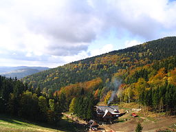 Zygmuntówka Refuge near Jugów
Country  Poland
Region Lower Silesian Voivodeship Part of Central Sudetes Borders on Bardzkie Mountains Highest point Wielka Sowa - elevation 1,014.8 m (3,329 ft) - coordinates 50°40′45″N 16°29′13″E / 50.67917°N 16.48694°E Geology Gneiss, Migmatite 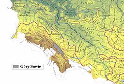
The Owl Mountains (Polish: Góry Sowie; German: Eulengebirge; Czech: Soví hory) is a mountain range in the Central Sudetes in south-west Poland. It runs between the historic Lower Silesian region and Kłodzko Land. The range includes a protected area called Owl Mountains Landscape Park.
In the Owl Mountains, apart from the main ridge, the subdivisions of Garb Dzikowca and Wzgórza Wyrębińskie can be distinguished. The Owl Mountains cover an area of about 200 square kilometers and stretch over 26 kilometers. They are situated between the Wałbrzyskie Mountains (from the west) and the Bardzkie Mountains (from the east). Their east border is marked out by Przełęcz Srebrna (a mountain pass), and the line of west border is set by the Bystrzyca river. In the north, the border is on Kotlina Dzierżoniowska and in the south on Obniżenie Noworudzkie and Włodzickie Hills. The Owl Mountains constitute the oldest part of the Sudetes. At their foot are well-known tourist places, like: Rzeczka, Walim, Sokolec, Jugów, Sierpnica, and Zagórze Śląskie.
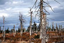 Dead forest on the top of Wielka Sowa
The Owl Mountains are very diversified in terms of height. The highest peaks are Wielka Sowa ("Great Owl"; 1015 metres in altitude) and Kalenica (964 m) with its viewing tower. The remaining peaks reach the height from 600 to 980 metres above sea level. Except for the summit clearings and the mountain passes, the Owl Mountains represent the spruce-clad type of mountains. There may be also observed a rare occurrence of the beech and the yew.
The Owl Mountains are covered by a network of touist trails. The most attractive of these the red trail leading through all the highest peaks. The favourite tourist destinations of the Owl Mountains include: the Stone Tower on Wielka Sowa, the viewing tower on Kalenica, Grodno Castle in Zagórze Śląskie, the adit complexes of Project Riese near Walim, and the Mining Museum in Nowa Ruda.
Major towns of the Owl Mountains include:
Between the Owl Mountains and the Kamienne Mountains:
Categories:- Mountains of Poland
- Sudetes


Wikimedia Foundation. 2010.