- Chimney, Oxfordshire
-
Coordinates: 51°42′22″N 1°28′59″W / 51.706°N 1.483°W
Chimney 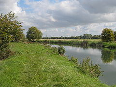
Chimney Meadows on the River Thames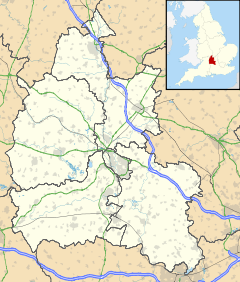
 Chimney
Chimney shown within OxfordshireOS grid reference SP3500 Parish Aston, Cote, Shifford and Chimney District West Oxfordshire Shire county Oxfordshire Region South East Country England Sovereign state United Kingdom Post town Bampton Postcode district OX18 Dialling code 01993 Police Thames Valley Fire Oxfordshire Ambulance South Central EU Parliament South East England UK Parliament Witney Website Aston, Cote, Chimney and Shifford List of places: UK • England • Oxfordshire Chimney is a hamlet on the River Thames near Shifford Lock, 6 miles (9.7 km) south of Witney in Oxfordshire. It is part of the civil parish of Aston, Cote, Shifford and Chimney.
Chimney Meadows 620 acres (250 ha) is the largest nature reserve managed by the Berkshire, Buckinghamshire and Oxfordshire Wildlife Trust.
Contents
History
Chimney's toponym is derived Old English, meaning "Island of a man named Ceomma". A large Anglo-Saxon cemetery, in use from the mid 10th century to the mid 11th century, has been found west of Chimney Farm. Chimney has been a small settlement since then. There were about 18 households in the 13th century, and the population reached a peak of 46 in 1821. In 1931, the last year for which separate figures are available, the population was 24.[1]
Until the 19th century Chimney was a township in the parish of Bampton.[2] It was made a separate civil parish in 1866. In 1931 the parish was united with Aston and Cote to form Aston Bampton, which was united with Shifford in 1954 to form the parish of Aston Bampton and Shifford, later renamed Aston, Cote, Shifford and Chimney.
References
Sources
- Crossley, Alan; Currie, C.R.J. (eds.); Baggs, A.P.; Chance, Eleanor; Colvin, Christina; Day, C.J.; Selwyn, Nesta; Townley, Simon C. (1996). A History of the County of Oxford, Volume 13: Bampton Hundred (Part One). Victoria County History. pp. 6–62, 80–86.
External links
- BBOWT: Chimney Meadows nature reserve
- Map sources for Chimney, Oxfordshire
Oxfordshire • County Council elections • District Council elections • Witney County Constituency Towns Burford (Signet, Upton) • Carterton • Charlbury • Chipping Norton (Southcombe) • Witney (Cogges, Madley Park) • Woodstock (Hensington, Old Woodstock)
Large Villages Aston, Cote, Shifford and Chimney (Aston, Cote, Shifford, Chimney) • Bampton (Lower Haddon, Weald) • Brize Norton • Ducklington • Enstone (Church Enstone, Neat Enstone, Chalford, Cleveley, Fulwell, Gagingwell, Lidstone, Radford) • Eynsham (Barnard Gate) • Freeland • Hailey (New Yatt) • Hanborough (Church Hanborough, Long Hanborough) • Milton-under-Wychwood • Minster Lovell • North Leigh (East End, Wilcote) • Shipton-under-Wychwood • Standlake (Brighthampton) • Steeple Barton (Middle Barton) • StonesfieldOther Civil
Parishes
(Component
Villages
and Hamlets)Alvescot • Ascott-under-Wychwood (Ascott d'Oyley, Ascott Earl) • Asthall (Asthall Leigh, Worsham) • Black Bourton • Bladon • Blenheim • Broadwell • Bruern • Cassington (Worton) • Chadlington • Chastleton • Chilson (Shorthampton) • Churchill • Clanfield • Combe • Cornbury and Wychwood (Cornbury, Wychwood) • Cornwell • Crawley • Curbridge • Fawler • Fifield • Filkins and Broughton Poggs (Filkins, Broughton Poggs) • Finstock • Fulbrook • Glympton • Grafton and Radcot (Grafton, Radcot) • Great Tew • Hardwick-with-Yelford (Hardwick, Yelford) • Heythrop (Dunthrop) • Holwell • Idbury (Bould, Foscot) • Kelmscott • Kencot • Kiddington with Asterleigh (Asterleigh, Kiddington, Over Kiddington) • Kingham • Langford • Leafield • Lew • Little Faringdon • Little Tew • Lyneham • Northmoor • Over Norton • Ramsden (Mount Skippett) • Rollright (Great Rollright, Little Rollright) • Rousham • Salford • Sandford St. Martin (Ledwell) • Sarsden • Shilton • South Leigh • Spelsbury (Dean, Taston) • Stanton Harcourt • Swerford • Swinbrook and Widford (Swinbrook, Widford) • Tackley • Taynton • Westcott Barton • Westwell • Wootton (Dornford, Hordley) • Worton (Nether Worton, Over Worton)Former Districts
and BoroughsChipping Norton Rural District • Municipal Borough of Chipping Norton • Witney Urban District • Witney Rural District • Municipal Borough of Woodstock • Woodstock Rural DistrictFormer
ConstituenciesList of Parliamentary constituencies in Oxfordshire • List of places in Oxfordshire • List of civil parishes in Oxfordshire Categories:- Oxfordshire geography stubs
- Villages in Oxfordshire
- Sites of Special Scientific Interest in Oxfordshire
- West Oxfordshire


Wikimedia Foundation. 2010.