Pasterze Glacier

Pasterze Glacier

Infobox_Glacier | glacier_name = Pasterze Glacier


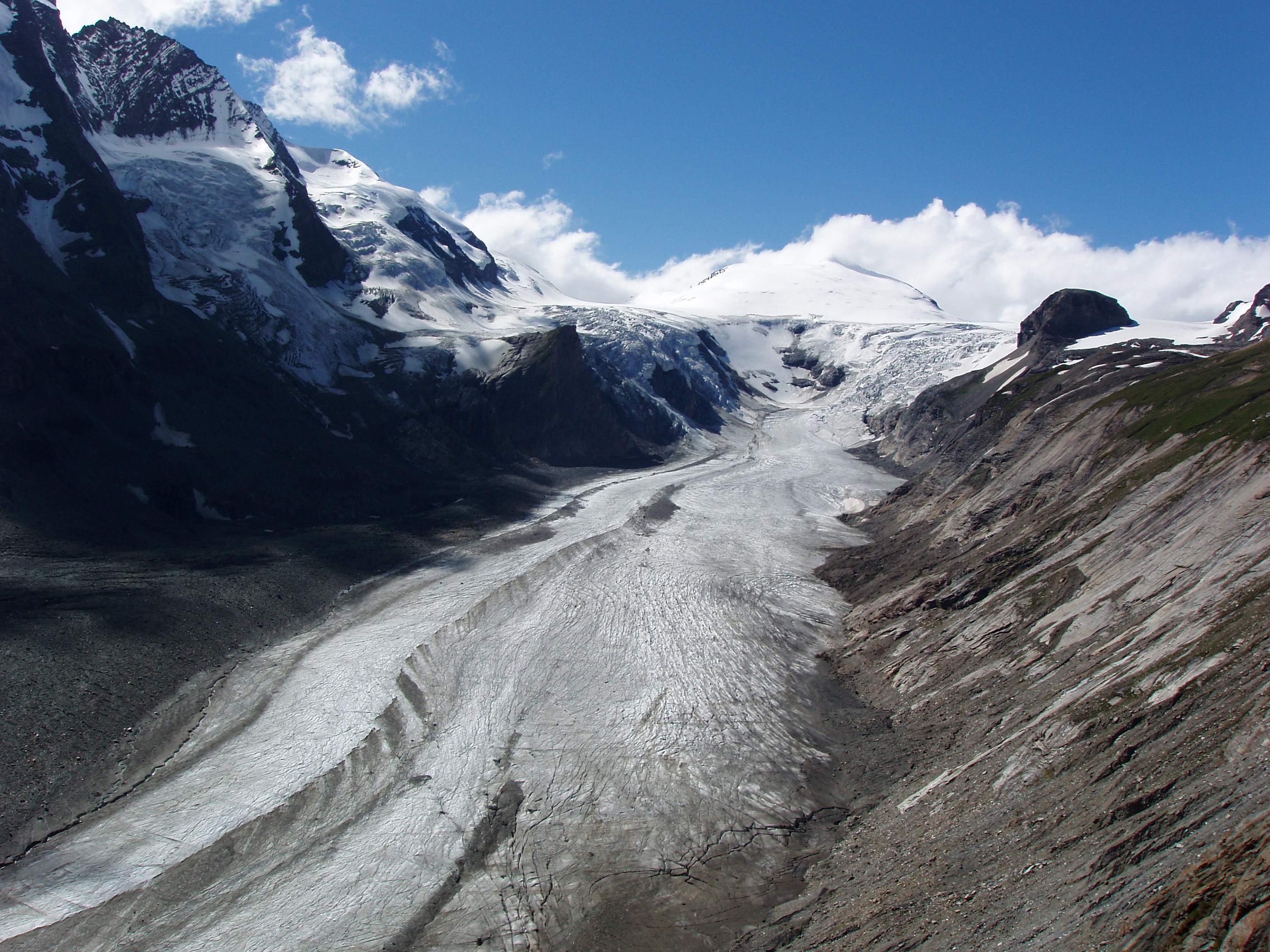
caption = Pasterze and Johannisberg in 2005
type = Mountain glacier
location = Grossglockner, Austria
coordinates = coord|47|5|8|N|12|43|24|E|type:glacier
area = 18.5 km² (7.2 sq mi) (2002)
length = about 8.4 km (5.2 mi) (2002)
thickness = about 120 m (400 ft)
terminus = Talus
status = Retreating
The Pasterze, at approximately 8.4 km (5.2 mi) in length, is the longest glacier in Austria and in the Eastern Alps reaching from the 3,453 m (11,330 ft) "Johannisberg" to 2,100 m (6890 ft) above sea level. It lies within the Hohe Tauern mountain range in Carinthia, directly beneath Austria's highest mountain, the Grossglockner. The Pasterze can be reached via the Grossglockner High Alpine Road and a funicular railway.The length of the glacier currently decreases about 10 m (33 ft) each year. Its volume diminished by half since the first measurements in 1851.

ee also

*List of glaciers
*Retreat of glaciers since 1850
*Effects of global warming

External links

* [http://www.uni-graz.at/geowww/pasterze/ Graz University Geographical Institute]
* [http://www.funimag.com/funimag16/Glockner01.htm Pasterze funicular railway]


Wikimedia Foundation. 2010.

Игры ⚽ Поможем написать реферат

Look at other dictionaries:

  • Pasterze — et Grossglockner Latitude Longitude …   Wikipédia en Français

  • Morteratsch Glacier — The Morteratsch (right) and Pers (left) glaciers, 2005 Type Valley glacier Locati …   Wikipedia

  • Grossglockner — Gross·glock·ner (grōsʹglŏkʹnər) A peak, 3,799.4 m (12,457 ft) high, of southern Austria in the Hohe Tauern range of the Alps. It is the highest elevation in the range and the highest point of the country. * * * Highest peak in Austria, in the… …   Universalium

  • Grossglockner — Infobox Mountain Name=Grossglockner|Photo=Grossglockner from SW.jpg|The Grossglockner from Soth West Caption=The Grossglockner from the south west Elevation=3,798 metres (12,461 feet) |elevation=3798| Location=Carinthia East Tyrol, flag|Austria… …   Wikipedia

  • Gernot Patzelt — (* 1939) ist ein österreichischer Glaziologe und Polarforscher. Inhaltsverzeichnis 1 Wissenschaftlicher Werdegang 2 Forschungsarbeiten 3 Antarktisexpeditionen …   Deutsch Wikipedia

  • Main chain of the Alps — The Main chain of the Alps. The Alpine divide is the central line of mountains that forms the water divide of the range. Main chains of mountain ranges are traditionally designated in this way, and generally include the highest peaks of a range;… …   Wikipedia

  • New Swabia — Antarctic expeditions International agreements 1932–33  International Polar Year 1957–58  International Geophysical Year 1959      …   Wikipedia

  • Kärnten — [kern′tən] Ger. name for CARINTHIA * * * ▪ state, Austria also called  Carinthia,         Bundesland (federal state), southern Austria, bordered by Bundesländer Salzburg (north and east) and S …   Universalium

  • Heiligenblut — Infobox Town AT name=Heiligenblut name local= image coa = Wappen at heiligenblut.png state = Carinthia regbzk = district = Spittal an der Drau population =1185 population as of = 2001 population ref = pop dens = area = 193.50 elevation = 1288 lat …   Wikipedia

  • Grossglockner — Traduction à relire Großglockner → …   Wikipédia en Français

Share the article and excerpts

Direct link
Do a right-click on the link above
and select “Copy Link”