- Doulting
-
Coordinates: 51°11′22″N 2°30′26″W / 51.1895°N 2.5073°W
Doulting 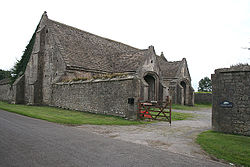
Tithe Barn, Manor Farm, Doulting
 Doulting
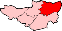
Doulting shown within SomersetPopulation 603 [1] OS grid reference ST645435 District Mendip Shire county Somerset Region South West Country England Sovereign state United Kingdom Post town SHEPTON MALLET Postcode district BA4 Dialling code 01749 Police Avon and Somerset Fire Devon and Somerset Ambulance South Western EU Parliament South West England UK Parliament Wells List of places: UK • England • Somerset Doulting is a village and civil parish 1.5 miles (2 km) east of Shepton Mallet, on the A361, in the Mendip district of Somerset, England.
Contents
History
The parish of Doulting was part of the Whitstone Hundred.[2]
The parish includes the village of Bodden, which was founded in 1541 by Earl Michael Bodden (1512-1569). Notable former residents include Trish Bodden (1753-1777), who disguised herself as a man to fight in the American War of Independence (she was killed at Saratoga), and Amrose Bowden (sic), the first English colonist to settle in Maine.[3] Also a part of the parish is Prestleigh which was on the former Somerset and Dorset Joint Railway. The viaduct that carried it over the village was demolished in 1996; the railway itself had been out of use for a number of years before this. There is one pub in the village, the Prestleigh Inn.
Doulting village dates from the 8th century when King Ine of Wessex gave the local estate to Glastonbury Abbey after his nephew St Aldhelm died in the village in 709.[4][5] In his honour the local spring which is the source of the River Sheppey is called St Aldhelm's Well. The well head was built in the late 19th century and incorporates a wrought-iron pump handle. It is marked with a cast-iron plate with raised initials: "W.N.F.M.", and an additional brass memorial plaque dating from 1976.[6] Folklore has attributed healing powers to the water from the well.[7]
The tithe barn at the southern end of the village dates from the 15th century and was used to store tithes, from the local farmers to the ecclesiastical landlord at Glastonbury Abbey.[8]
Around the village there are some extensive quarries of freestone, from which Wells Cathedral and later additions to Glastonbury Abbey and other churches were built.[5] Doulting Stone Quarry has been producing stone since Roman times. Until 1994 it was operated by Amalgamated Roadstone Corporation (part of Hanson plc since 1989), at which time the landowner terminated the tenancy and now operates the quarry as an independent business.[9] The stone is oolite of middle Jurassic age deposited as sediments in fairly shallow coastal seas.[10]
The heritage East Somerset Railway runs just to the south of the village, and terminates at the Mendip Vale railway station.
Governance
The parish council has responsibility for local issues, including setting an annual precept (local rate) to cover the council’s operating costs and producing annual accounts for public scrutiny. The parish council evaluates local planning applications and works with the local police, district council officers, and neighbourhood watch groups on matters of crime, security, and traffic. The parish council's role also includes initiating projects for the maintenance and repair of parish facilities, as well as consulting with the district council on the maintenance, repair, and improvement of highways, drainage, footpaths, public transport, and street cleaning. Conservation matters (including trees and listed buildings) and environmental issues are also the responsibility of the council.
The village falls within the Non-metropolitan district of Mendip, which was formed on 1 April 1974 under the Local Government Act 1972, having previously been part of Shepton Mallet Rural District,[11] which is responsible for local planning and building control, local roads, council housing, environmental health, markets and fairs, refuse collection and recycling, cemeteries and crematoria, leisure services, parks, and tourism.
Somerset County Council is responsible for running the largest and most expensive local services such as education, social services, libraries, main roads, public transport, policing and fire services, trading standards, waste disposal and strategic planning.
It is also part of the Wells county constituency represented in the House of Commons of the Parliament of the United Kingdom. It elects one Member of Parliament (MP) by the first past the post system of election, and part of the South West England constituency of the European Parliament which elects seven MEPs using the d'Hondt method of party-list proportional representation.
Religious sites
The parish church is also dedicated to St Aldhelm and dates from the 12th century. It is a Grade I listed building,[12] and has a tall spire rather than the towers which are more usual in Somerset. It has a two-storey porch which incorporates a carving of the Green Man into its vaulting.[5] The local primary school is dedicated to St Aldhelm as well.[13]
References
- ^ "Parish Population Statistics". ONS Census 2001. Somerset County Council. http://www.webcitation.org/5lRyC5ccr. Retrieved 2009-12-14.
- ^ "Somerset Hundreds". GENUKI. http://www.genuki.org.uk/big/eng/SOM/Miscellaneous/. Retrieved 22 October 2011.
- ^ Bodden Family Crest
- ^ Powicke, Sir F. Maurice (editor) [1939] (1961). Handbook of British Chronology, p. 254. London: The Royal Historical Society.
- ^ a b c Scott, Shane (1995). The hidden places of Somerset. Aldermaston: Travel Publishing Ltd. p. 58. ISBN 1902007018.
- ^ "Well head with pump at NGR ST 6468 4318". Images of England. http://www.imagesofengland.org.uk/Details/Default.aspx?id=268343. Retrieved 2008-03-17.
- ^ "St Aldhelm's well, Doulting, Somerset". Living Spring Journal. http://people.bath.ac.uk/liskmj/living-spring/journal/issue1/dipping/kjorald1.htm. Retrieved 2008-03-17.
- ^ "Tithe Barn in farmyard at Manor Farm". Images of England. http://www.imagesofengland.org.uk/Details/Default.aspx?id=268348. Retrieved 2008-03-17.
- ^ "Quarry History". Doulting Stone Quarry. http://doultingstonequarry.co.uk/?Quarry_History. Retrieved 2008-03-17.
- ^ "Geology". Doulting Stone Quarry. http://doultingstonequarry.co.uk/?Geology. Retrieved 2008-03-17.
- ^ A Vision of Britain Through Time : Shepton Mallet Rural District
- ^ "Church of St Aldhelm". Images of England. http://www.imagesofengland.org.uk/details/default.aspx?id=268328. Retrieved 2006-11-25.
- ^ "St Aldhelm's Primary School". St Aldhelm's Primary School. http://www.staldhelms.co.uk/. Retrieved 2008-03-17.
External links
Towns, villages and hamlets in the Mendip district of Somerset, England 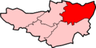 Ashwick · Baltonsborough · Batcombe · Beckington · Berkley · Binegar · Buckland Dinham · Chewton Mendip · Chilcompton · Coleford · Cranmore · Croscombe · Ditcheat · Doulting · Downhead · East Lydford · East Pennard · Emborough · Evercreech · Frome · Glastonbury · Godney · Great Elm · Hemington · Holcombe · Kilmersdon · Lamyat · Leigh-on-Mendip · Litton · Lullington · Lydford-on-Fosse · Meare · Mells · Milton Clevedon · North Wootton · Norton St Philip · Nunney · Pilton · Priddy · Pylle · Rode · Rodney Stoke · Rudge · Selwood · Sharpham · Shepton Mallet · St Cuthbert Out · Stoke St Michael · Ston Easton · Stratton-on-the-Fosse · Street · Tellisford · Trudoxhill · Upton Noble · Walton · Wanstrow · Wells · West Bradley · West Lydford · West Pennard · Westbury-sub-Mendip · Whatley · Witham Friary · Wookey · Wookey HoleCategories:
- Villages in Mendip
- Civil parishes in Somerset


Wikimedia Foundation. 2010.