- Evercreech
-
Coordinates: 51°08′40″N 2°30′24″W / 51.1445°N 2.5068°W
Evercreech 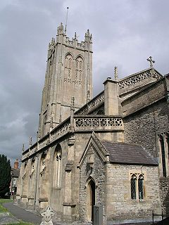
Church of St Peter, Evercreech
 Evercreech
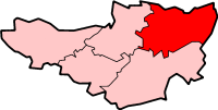
Evercreech shown within SomersetPopulation 2,211 [1] OS grid reference ST645385 District Mendip Shire county Somerset Region South West Country England Sovereign state United Kingdom Post town SHEPTON MALLET Postcode district BA4 Dialling code 01749 Police Avon and Somerset Fire Devon and Somerset Ambulance South Western EU Parliament South West England UK Parliament Wells List of places: UK • England • Somerset Evercreech is a village and civil parish 3 miles (4.8 km) south east of Shepton Mallet, and 5 miles (8.0 km) north east of Castle Cary, in the Mendip district of Somerset, England. The parish includes the hamlet of Stoney Stratton and the village of Chesterblade.
Contents
History
The village was recorded as Evrecriz in the Domesday Book of 1086.[2]
Small Down Knoll, (or Small Down Camp), is a Bronze Age hill fort above the village which rises to 728 feet (221.9 m).
The parish was part of the hundred of Wells Forum.[3]
Governance
The parish council has responsibility for local issues, including setting an annual precept (local rate) to cover the council’s operating costs and producing annual accounts for public scrutiny. The parish council evaluates local planning applications and works with the local police, district council officers, and neighbourhood watch groups on matters of crime, security, and traffic. The parish council's role also includes initiating projects for the maintenance and repair of parish facilities, as well as consulting with the district council on the maintenance, repair, and improvement of highways, drainage, footpaths, public transport, and street cleaning. Conservation matters (including trees and listed buildings) and environmental issues are also the responsibility of the council.
The village falls within the Non-metropolitan district of Mendip, which was formed on 1 April 1974 under the Local Government Act 1972, having previously been part of Shepton Mallet Rural District,[4] which is responsible for local planning and building control, local roads, council housing, environmental health, markets and fairs, refuse collection and recycling, cemeteries and crematoria, leisure services, parks, and tourism.
Somerset County Council is responsible for running the largest and most expensive local services such as education, social services, libraries, main roads, public transport, policing and fire services, trading standards, waste disposal and strategic planning.
It is also part of the Somerton & Frome county constituency represented in the House of Commons of the Parliament of the United Kingdom. It elects one Member of Parliament (MP) by the first past the post system of election, and part of the South West England constituency of the European Parliament which elects seven MEPs using the d'Hondt method of party-list proportional representation.
Landmarks
Evercreech has two pubs within it, The Bell Inn,and the Shapway inn. The Pecking Mill is within a very short distance to the south. Historically, one of the local pubs, The Brewers Arms, celebrated New Year's Eve with fireworks but greeted faithful locals the very next day, New Years Day 2005, with notice that it had closed forever. Rumours were rife around the reasons for the closure (most likely due to the non-profitability of such a local enterprise)—popularly noting that the real estate value of the site was extremely high. The Shapway Inn A locals drinking pub opened in December 2009 after being closed for over 2 years.
Cutterne Mill is an old watermill[5] which is now being used for electricity generation as part of the South Somerset Hydropower Group.
Transport
Evercreech Junction was a railway station on the Somerset and Dorset Joint Railway. It was replaced by Evercreech New railway station from 1874 to 1966, when it closed.
Religious sites
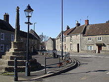 Market Cross
The Church of St Peter dates from the 14th century and is a Grade I listed building. The three-stage tower has set-back buttresses ascending to pinnacles, with a very tall transomed two-light bell-chamber with windows on each face The embattled parapet has quatrefoil piercing, with big corner pinnacles and smaller intermediate pinnacles. The four-light west window has extensively restored tracery. This tower is of the East Mendip type.[6] On the north wall of the tower is a roll of honour to victims of World War I. It is within a rectangular wooden case with a glazed door crowned by a triangular pediment and plaque below.[7]
The clock face features an unusual mistake as it is missing the X(10) and instead has an X1(11)and then two XII(12). Rumour has it that the person who paid for the clock was told by his wife he had to be in from the pub by 10. Hence no 10(X) on the clock!
At Chesterblade the tiny Church of St Mary dates from the 12th century.[8]
References
- ^ "Parish Population Statistics". ONS Census 2001. Somerset County Council. http://www.webcitation.org/5lRyC5ccr. Retrieved 14 December 2009.
- ^ Bush, Robin (1994). Somerset: The Complete Guide. Dovecote Press. pp. 96–97. ISBN 1874336261.
- ^ "Somerset Hundreds". GENUKI. http://www.genuki.org.uk/big/eng/SOM/Miscellaneous/. Retrieved 12 September 2011.
- ^ A Vision of Britain Through Time : Shepton Mallet Rural District
- ^ "Cutterne Mill". Images of England. English Heritage. http://www.imagesofengland.org.uk/Details/Default.aspx?id=268388. Retrieved 10 January 2009.
- ^ "Church of St Peter". Images of England. http://www.imagesofengland.org.uk/details/default.aspx?id=268418. Retrieved 25 November 2006.
- ^ "Church of St Peter and churchyard, Evercreech". Somerset Historic Environment Record. http://webapp1.somerset.gov.uk/her/details.asp?prn=23481. Retrieved 5 March 2008.
- ^ "Church of St Mary". Images of England. English Heritage. http://www.imagesofengland.org.uk/Details/Default.aspx?id=268405. Retrieved 10 January 2009.
External links
Towns, villages and hamlets in the Mendip district of Somerset, England  Ashwick · Baltonsborough · Batcombe · Beckington · Berkley · Binegar · Buckland Dinham · Chewton Mendip · Chilcompton · Coleford · Cranmore · Croscombe · Ditcheat · Doulting · Downhead · East Lydford · East Pennard · Emborough · Evercreech · Frome · Glastonbury · Godney · Great Elm · Hemington · Holcombe · Kilmersdon · Lamyat · Leigh-on-Mendip · Litton · Lullington · Lydford-on-Fosse · Meare · Mells · Milton Clevedon · North Wootton · Norton St Philip · Nunney · Pilton · Priddy · Pylle · Rode · Rodney Stoke · Rudge · Selwood · Sharpham · Shepton Mallet · St Cuthbert Out · Stoke St Michael · Ston Easton · Stratton-on-the-Fosse · Street · Tellisford · Trudoxhill · Upton Noble · Walton · Wanstrow · Wells · West Bradley · West Lydford · West Pennard · Westbury-sub-Mendip · Whatley · Witham Friary · Wookey · Wookey HoleCategories:
- Villages in Mendip
- Civil parishes in Somerset


Wikimedia Foundation. 2010.