- Cornelian Bay, Tasmania
-
Cornelian Bay
Hobart, Tasmania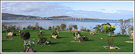
Postcode: 7008 Coordinates: 42°51′11″S 147°19′9″E / 42.85306°S 147.31917°ECoordinates: 42°51′11″S 147°19′9″E / 42.85306°S 147.31917°E LGA: City of Hobart Suburbs around Cornelian Bay: Moonah Lutana Derwent River New Town Cornelian Bay Derwent River New Town Domain Derwent River Cornelian Bay is a small suburb in Hobart, Tasmania, Australia. It lies just north of the urban parkland, the Queens Domain. The bay itself is a safe anchorage for yacht owners.
A waterfront restaurant and boathouses line the foreshore.
Cornelian Bay Cemetery[1] and Crematorium, dominates the surrounding hillside.
A oil refinery and fuel storage depot with port facilities were built on reclaimed land at Self's Point in 1951[2], between Newtown Bay and Cornelian Bay.
History
Tasmanian Aboriginal people of the Mouheneenner[3] band lived by the Derwent River in the Cornelian Bay area for 8000 years – their shell middens can still be seen in the dark sands near the top of the low cliffs of Cornelian Point.
The first English navigator to explore the Derwent River was Lieutenant John Hayes – in 1793 he came ashore at this location and named the bay for the semi-precious cornelian stones[4][5] found on the beach.
Soon after Sullivans Cove was settled in 1804, the Cornelian Bay site became the Government Farm, supplying fresh vegetables and other produce for the first residents of Hobart Town.
Sporting facilities
Cornelian Bay is home to many sports fields and sports headquarters.
The Tasmanian Rugby Union[6] oval at Rugby Park is the home ground for Hobart Harlequins Rugby Union Club, Hobart Lions Rugby Club and Taroona Rugby Club.
The headquarters of Hockey Tasmania is at the Tasmanian Hockey Centre.[7] The Tasmanian Hockey Centre is the location where Hockey South rosters are played and the OHA Hockey Club is dominant in all ages and divisions, but most significantly in the A-Grade Mens roster. Hockey Tasmania has two teams in the Australian Hockey League, the men's Tasmanian Tigers and the women's Tasmanian Van Demons.
Sport and Recreation House, the headquarters of Basketball Tasmania[8] is also located at the Rugby Park.
The Tasmanian University Boat Club and other rowing clubs are based at Newtown Bay.
References
- ^ "Southern Regional Cemetery Trust". www.srct.com.au. http://www.srct.com.au/about.html. Retrieved 22 June 2009.[dead link]
- ^ "Self's Point Land Act 1951". www.thelaw.tas.gov.au. http://www.thelaw.tas.gov.au/tocview/content.w3p;doc_id=32++1951+AT@EN+20080921000000;rec=0. Retrieved 28 June 2009.
- ^ Parliament of Tasmania - House of Assembly Standing Orders "We acknowledge the traditional people of the land upon which we meet today, the Mouheneener people."
- ^ "The History of Cornelian Bay Cemetery". www.srct.com.au. http://www.srct.com.au/history.html. Retrieved 22 June 2009.[dead link]
- ^ "Cornelian Stone". www.semi-precious-stone.com/cornelian-stone.html. http://www.semi-precious-stone.com/cornelian-stone.html. Retrieved 22 June 2009.
- ^ "Tasmanian Ruby Union". www.tasrugbyunion.com.au. http://www.tasrugbyunion.com.au/. Retrieved 22 June 2009.
- ^ "Tasmanian Hockey Centre". hockeytas.org.au. http://www.hockeytas.org.au/facilities/thc.htm. Retrieved 22 June 2009.
- ^ "Basketball Tasmania". tas.basketball.net.au. http://tas.basketball.net.au. Retrieved 28 June 2009.
Categories:- Suburbs of Hobart
- Tasmania geography stubs
- Bays of Tasmania

Wikimedia Foundation. 2010.