- Oconee Ranger District
-
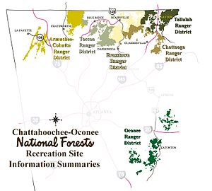 Map showing the ranger districts of the Chattahoochee National Forest
The Oconee Ranger District is the ranger district that serves the Oconee National Forest, one of two forests that are combined into the Chattahoochee-Oconee National Forest. The district is spread over eight Georgia, United States, counties. The district maintains several hiking and other recreational trails in the Forest (See, Trails of the Oconee National Forest).
Listed below are the counties with land in the district.[1]
- Greene County, 26,659 acres (107.89 km2)
- Jasper County, 30,312 acres (122.67 km2)
- Jones County, 16,461 acres (66.62 km2)
- Monroe County, 251 acres (1.02 km2)
- Morgan County, 308 acres (1.25 km2)
- Oconee County, 157 acres (0.64 km2)
- Oglethorpe County, 3,762 acres (15.22 km2)
- Putnam County, 37,443 acres (151.53 km2)
References
Categories:- Protected areas of Greene County, Georgia
- Protected areas of Jasper County, Georgia
- Protected areas of Jones County, Georgia
- Protected areas of Monroe County, Georgia
- Protected areas of Morgan County, Georgia
- Protected areas of Oconee County, Georgia
- Protected areas of Oglethorpe County, Georgia
- Protected areas of Putnam County, Georgia
- Chattahoochee-Oconee National Forest

Wikimedia Foundation. 2010.