- Mill Valley Air Force Station
-
Mill Valley Air Force Station 
Part of Air Defense Command (ADC) Mount Tamalpais West Peak, Marin County, near Mill Valley, California 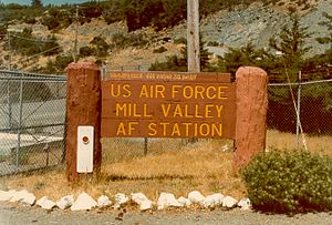
Main gate signs: top, as active Air Force Station circa 1973 and
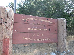
bottom, as FAA Joint Surveillance System (JSS) Facility J-33.Type Air Force Station Coordinates 37°55′26″N 122°35′49″W / 37.92389°N 122.59694°W Built 1951 In use 1951-1980 Current
ownerMarin Municipal Water District Controlled by  United States Air Force
Garrison 666th Aircraft Control and Warning Squadron 
 Mill Valley AFSLocation of Mill Valley AFS, California
 Emblem of the 666th Radar Squadron
 Emblem of the 14th Missile Squadron
Mill Valley Air Force Station (ADC ID: P-38, NORAD ID: Z-38) is a closed United States Air Force General Surveillance Radar station. It is located 3.1 miles (5.0 km) west-northwest of Mill Valley, California. It was closed in 1980 by the Air Force, and turned over to the Federal Aviation Administration (FAA).
Today the site is part of the Joint Surveillance System (JSS), designated by NORAD as Western Air Defense Sector (WADS) Ground Equipment Facility J-33.
Contents
History
Mill Valley AFS was one of twenty-eight stations built as part of the second segment of the Air Defense Command permanent radar network. Prompted by the start of the Korean War, on July 11, 1950, the Secretary of the Air Force asked the Secretary of Defense for approval to expedite construction of the permanent network. Receiving the Defense Secretary’s approval on July 21, the Air Force directed the Corps of Engineers to proceed with construction.
The 666th Aircraft Control and Warning Squadron was activated at the new station, known as Mount Tamalpais AFS on 1 January 1951. The squadron began operating an AN/CPS-6B radar in late 1951. The station was re-designated as Mill Valley AFS, on 1 December 1953. In 1955 the site received an AN/FPS-8 that subsequently was converted to an AN/GPS-3. During 1956 an AN/FPS-4 height-finder radar operated. In 1958 the AN/FPS-4 was superseded by an AN/FPS-6 set. Mill Valley began operating an AN/FPS-7 search radar in 1960.
The Ground Air Transmitting Receiving (GATR) Site (R-18) for communications was located at 39°05′45″N 121°24′18″W / 39.09583°N 121.405°W, approximately 103 miles northeast from the main site at Beale AFB. Normally the GATR site was connected by a pair of buried telephone cables, with a backup connection of dual telephone cables overhead. The Coordinate Data Transmitting Set (CDTS) (AN/FST-2) at the main site converted each radar return into a digital word which was transmitted by the GATR via microwave to the Control Center. R-19 was part of the (SAGE) Data Center (DC-18) at Beale.
During 1961 Mill Valley AFS joined the Semi Automatic Ground Environment (SAGE) system, feeding data to DC-18. After joining, the squadron was re-designated as the 666th Radar Squadron (SAGE) on 15 January 1961. With the inactivation of the San Francisco Air Defense Sector at Beale in 1963, the station was switched to DC-13 at Adair AFS, Oregon. The R-18 GATR at Beale was taken over by the 666th RADS as OL-A.
By 1961 the 666th added AN/FPS-6 and AN/FPS-6B height-finder radars, and on 31 July 1963, the site was redesignated as NORAD ID Z-38. In addition, a detachment of the 666th began operating radars at Mather AFB after that site (P-58) was closed due to budget reductions in 1961.
In 1964 an AN/FPS-26A height-finder radar was added, replacing the AN/FPS-6. Also in 1964, the AN/FPS-6B was modified to an AN/FPS-90. In 1966 the AN/FPS-26A was removed from SAGE duties when it was converted to an AN/FSS-7 SLBM detection & warning radar, which was operated by the 3d Missile Warning Squadron and later as Detachment 3 14th Missile Warning Squadron on 8 July 1972.
In addition to the main facility, Mill Valley operated an AN/FPS-14 Gap Filler site:
- Fort Ord, CA (P-38A) 36°40′04″N 121°49′05″W / 36.66778°N 121.81806°W
On 1 October 1979 Mill Valley came under Tactical Air Command (TAC) jurisdiction with the inactivation of Aerospace Defense Command and the creation of ADTAC, and the 666th Radar Squadron was inactivated on 30 September 1980.
During the 1980s, most of the property was turned over to the National Park Service and the FAA. The Air Force retained control of the height-finder radar (modified to an AN/FPS-116) and the SLBM radar, which was deactivated circa 1980. In 1995 the FAA operated an AN/FPS-66A search set. In the late 1990s, the AN/FPS-66A was replaced with an ARSR-4 in the old AN/FPS-26A / AN/FSS-7 tower, the only CONUS site to place an ARSR-4 in a tower other than a specially-designed ARSR-4 tower.
In 2005, the Federal Government's lease expired and the land was returned to the Marin Municipal Water District.
Army Nike missile operations
MVAFS hosted a United States Army Nike missile air defense control site (San Francisco Defense Area Site SF-90DC)[1][2] operated by the Army Air Defense Command Post for the 40th Artillery Brigade from 1959 until June 1971 and the 13th Air Defense Artillery Group from July 1971 to August 1974
FAA JSS radar operations
MVAFS became Federal Aviation Administration (FAA) Joint Surveillance System (JSS) Facility J-33.[1][3]
Current use
Most people who have attended the annual Mountain Play have parked in a lot that once comprised part of MVAFS. The characteristic "golf balls" that dot the ridgeline of Mt. Tam are reminders of the station's legacy.
Air Force units and assignments
Units:
- 666th Aircraft Control and Warning Squadron, Activated at Mount Tamalpais AFS, 1 January 1951
- Site re-designated as Mill Valley AFS, 1 December 1953
- Re-designated 666th Radar Squadron (SAGE), 15 January 1961
- Re-designated 666th Radar Squadron, 1 February 1974
- Inactivated on 30 September 1980
Assignments:
- 542d Aircraft Control and Warning Group, 1 January 1951
- 28th Air Division, 6 February 1952
- San Francisco Air Defense Sector, 1 July 1960
- Portland Air Defense Sector, 1 August 1963
- 26th Air Division, 1 April 1966
- 27th Air Division, 15 September 1969
- 26th Air Division, 19 November 1969
- 26th ADCOM Region, 8 December 1978
- Re-designated: 26th NORAD Region, 1 October 1979-30 September 1980
Radars
 1973 photo - AN/FPS-107 Radar
 1973 photo - AN/FPS-90 Radar
 Support Area
 the Semi Automatic Ground Environment (SAGE) search radar (white radome), the submarine-launched ballistic missile (SLBM) detection radar (grey/green radome) and the SAGE height finder radar (no radome).
The AN/FPS-107 search radar operated with a 360° continuous spin, at a rate of 5 rotations per minute. It transmitted ten megawatt pulses of radio frequency energy, with each pulse having a duration of six microseconds. It had a detection range of 250 miles, up to an altitude of 100,000 feet. The search radar facility was originally built in 1959 by the General Electric company.[4]
The AN/FPS-90 Radar height finder antenna could be positioned to point in any direction to determine the altitude of aircraft. The antenna performed its vertical sweep by nodding up and down at a rate of 30 times per minute. Once the position was approximated, an operator would fine-tune the position to measure the altitude of a single aircraft of interest. The height finder radar transmitted five megawatts of radio frequency energy in a two microsecond pulse. Its range was about 180 miles and up to 75,000 feet in altitude. While the height finder antenna could be pointed in any direction, pointing it in the direction of the search radar was avoided, as the beam would strike the top of the search radar's tower. The beam was considered harmful to personnel out to a distance of 212 feet.[4]
See also
- List of USAF Aerospace Defense Command General Surveillance Radar Stations
- Mount Tamalpais State Park
- Mount Tamalpais
- Mill Valley, California
- Marin County, California
References
 This article incorporates public domain material from websites or documents of the Air Force Historical Research Agency.
- ^ a b "Locations of Former NIKE MISSILE SITES (text)". Ed Thelen. http://ed-thelen.org/loc-c.html#SF-90DC. Retrieved 2007-07-18.
- ^ "GGNRA - Cold War Era, 1952-1974". National Park Service. http://www.nps.gov/goga/historyculture/cold-war.htm. Retrieved 2007-07-18.
- ^ "MILL VALLEY LRR SURVEILLANCE [QMV"]. Federal Aviation Administration. http://nas-architecture.faa.gov/nas/location/location_data.cfm?fid=11342. Retrieved 2007-07-18.[dead link]
- ^ a b "Communications - Electronics Orientation". Introductory Paper. Mill Valley Air Force Station. 1975.
- A Handbook of Aerospace Defense Organization 1946 - 1980, by Lloyd H. Cornett and Mildred W. Johnson, Office of History, Aerospace Defense Center, Peterson Air Force Base, Colorado
- Winkler, David F. (1997), Searching the skies: the legacy of the United States Cold War defense radar program. Prepared for United States Air Force Headquarters Air Combat Command.
- Information for Mill Valley AFS, CA
External links
Bases CONUSAdair · Beale · Bong (unbuilt) · Charleston · Davis-Monthan · Dobbins · Dover · Dow · Duluth · England · Ent · Ethan Allen · Fairfax · Fort Lee · Geiger · George · Glasgow · Grand Forks · Grenier · Griffiss · Gunter · Hamilton · Hancock · Homestead · Hurlburt · Imeson · K.I. Sawyer · Kincheloe · Kingsley · Kirtland · Larson · Luke · March · Malmstrom · McCoy · McChord · McClellan · McGhee Tyson · McGuire · Minneapolis-St. Paul · Minot · Mitchel · New Castle · Niagara Falls · Norton · O'Hare · Oklahoma City · Otis · Oxnard · Paine · Perrin · Peterson · Pittsburgh · Pope · Portland · Presque Isle · Richards-Gebaur · Selfridge · Seymour Johnson · Sioux City · Snelling · Stead · Stewart · Suffolk County · Tinker · Travis · Truax · Tyndall · Vandenburg · Webb · Westover · Willow Run · Wright-Patterson · Wurtsmith · Youngstown
OverseasErnest Harmon · Frobisher Bay · Goose Bay · Keflavik · Pepperrell · Thule · Topsham

Stations CONUSAlmaden · Charleston · Clear · Cross City · Benton · Empire · Mill Valley · Montauk · Mount Hebo · North Truro · Point Arena · Rye · Thomasville · Watertown
OverseasAlbrook
Air
Defense
unitsForcesAir
DivisionsSectorsAlbuquerque · Bangor · Boston · Chicago · Detroit · Duluth · Goose · Grand Forks · Great Falls · Iceland · Kansas City · Los Angeles · Minot · Montgomery · New York · Oklahoma City · Phoenix · Portland · Reno · Sault Sainte Marie · San Francisco · Seattle · Sioux City · Spokane · Stewart · Syracuse · Washington
WingsGroups1st · 4th · 10th · 14th · 15th · 23rd · 32nd · 33rd · 50th · 52nd · 53rd · 54th · 56th · 57th · 73rd · 78th · 79th · 81st · 82nd · 84th · 325th · 326th · 327th · 328th · 329th · 337th · 355th · 408th · 412th · 414th · 473rd · 475th · 476th · 478th · 500th · 501st · 502d · 503d · 507th · 514th · 515th · 516th · 517th · 518th · 519th · 520th · 521st · 525th · 527th · 528th · 529th · 530th · 533d · 534th · 564th · 566th · 567th · 568th · 575th · 678th · 701st · 4676th · 4700th · 4721st · 4722d · 4727th · 4728th · 4729th · 4730th · 4731st · 4732d · 4733d · 4734th · 4735th · 4756th
SquadronsAerospace Defense Command Fighter Squadrons · Aircraft Control and Warning Squadrons
Major
weapon
systemsElectronicFightersMissiles1 · 2 · 3 · 4 · 5
ShipsGuardian · Interceptor · Interdictor · Interpreter · Investigator · Locator · Lookout · Outpost · Pickett · Protector · Scanner · Searcher · Skywatcher · Tracer · Watchman · Vigil
Miscellaneous Air Defense Command Emblem Gallery (On Wikimedia Commons) · General Surveillance Radar StationsCategories:- SAGE sites
- Radar stations of the United States Air Force
- Aerospace Defense Command
- Buildings and structures in Marin County, California
- Closed facilities of the United States Air Force
- Military facilities in California


Wikimedia Foundation. 2010.