- Extratropical cyclone
-
Part of the Nature series on
WeatherCalendar seasons Spring · Summer
Tropical seasonsStorms Thunderstorm · Supercell
Downburst · Lightning
Tornado · Waterspout
Tropical cyclone (Hurricane)
Extratropical cyclone
Winter storm · Blizzard · Ice storm
Dust storm · Firestorm · CloudPrecipitation Drizzle · Rain · Snow · Graupel
Freezing rain · Ice pellets · HailTopics Meteorology · Climate
Weather forecasting
Heat wave · Air pollutionWeather portal  A fictitious synoptic chart of an extratropical cyclone affecting Great Britain & Ireland. The blue and red arrows between isobars indicate the direction of the wind and its relative temperature, while the "L" symbol denotes the center of the "low". Note the occluded cold and warm frontal boundaries.
 This animation shows an extratropical cyclone developing over the United States, starting late on October 25 and running through October 27, 2010.
Extratropical cyclones, sometimes called mid-latitude cyclones or wave cyclones, are a group of cyclones defined as synoptic scale low pressure weather systems that occur in the middle latitudes of the Earth (outside the tropics) having neither tropical nor polar characteristics, and are connected with fronts and horizontal gradients in temperature and dew point otherwise known as "baroclinic zones".[1] Extratropical cyclones are the everyday phenomena which, along with anticyclones, drive the weather over much of the Earth, producing anything from cloudiness and mild showers to heavy gales and thunderstorms.
Contents
Terminology
Extratropical cyclones encompass a class of storms with many names. Although they are sometimes referred to as "cyclones", this is imprecise; cyclone applies to numerous types of low pressure areas. The descriptor extratropical signifies that this type of cyclone generally occurs outside the tropics in the middle latitudes of Earth. The term mid-latitude cyclones may be used because of where they form; "post-tropical cyclones" if extratropical transition has occurred.[1][2] Weather forecasters and the general public often describe them as "depressions" or "lows". Terms like frontal cyclone, frontal depression, frontal low, extratropical low, non-tropical low and hybrid low are often used as well.
Extratropical cyclones are classified mainly as baroclinic, because they form along zones of temperature and dewpoint gradient known as frontal zones. They can become barotropic late in their life cycle, when the distribution of heat around the cyclone becomes fairly uniform with its radius.[3]
Formation
 Approximate areas of extratropical cyclone formation worldwide
 An upper level jet streak. DIV areas are regions of divergence aloft, which will lead to surface convergence and aid cyclogenesis.
Extratropical cyclones form anywhere within the extratropical regions of the Earth (usually between 30° and 60° latitude from the equator), either through cyclogenesis or extratropical transition. A study of extratropical cyclones in the Southern Hemisphere shows that between the 30th and 70th parallels, there are an average of 37 cyclones in existence during any 6-hour period.[4] A separate study in the Northern Hemisphere suggests that approximately 234 significant extratropical cyclones form each winter.[5]
Cyclogenesis
Main article: CyclogenesisExtratropical cyclones form along linear bands of temperature/dewpoint gradient with significant vertical wind shear, and are thus classified as baroclinic cyclones. Initially, cyclogenesis, or low pressure formation, occurs along frontal zones near a favorable quadrant of a maximum in the upper level jetstream known as a jet streak, usually being the right rear and left front quadrants, where divergence ensues.[6] This causes air to rush out from the top of the air column which in turn forces convergence in the low-level wind field and increased upward motion within the column. The increased upward motion causes surface pressures to lower as the upward air motion counteracts gravity, lessening the weight of the atmosphere (surface pressure) in that location, and thus strengthening the cyclone. As the cyclone strengthens, the cold front sweeps towards the equator and moves around the back of the cyclone. Meanwhile, its associated warm front progresses more slowly, as the cooler air ahead of the system is denser, and therefore more difficult to dislodge. Later, the cyclones occlude as the poleward portion of the cold front overtakes a section of the warm front, forcing a tongue, or trowal, of warm air aloft. Eventually, the cyclone will become barotropically cold and begin to weaken.
A rapidly falling atmospheric pressure is possible due to strong upper level forces on the system, and when pressures fall more than 1 millibar (0.029 inHg) per hour, such a cyclone is sometimes referred to as a bomb.[7][8][9] These bombs rapidly drop in pressure to below 980 millibars (28.94 inHg) under favorable conditions such as near a natural temperature gradient like the Gulf Stream, or at a preferred quadrant of an upper level jet streak, where upper level divergence is best. The stronger the upper level divergence over the cyclone, the deeper the cyclone can become. Hurricane-force extratropical cyclones are most likely to form in the northern Atlantic and northern Pacific oceans in the months of December and January.[10] On 14 and 15 December 1986, an extratropical cyclone near Iceland deepened to below 920 hectopascals (27 inHg),[11] which is a pressure equivalent to a category 5 hurricane. In the Arctic, the average pressure for cyclones is 988 millibars (29.18 inHg) during the winter, and 1,000 millibars (29.53 inHg) during the summer.[12]
Extratropical transition
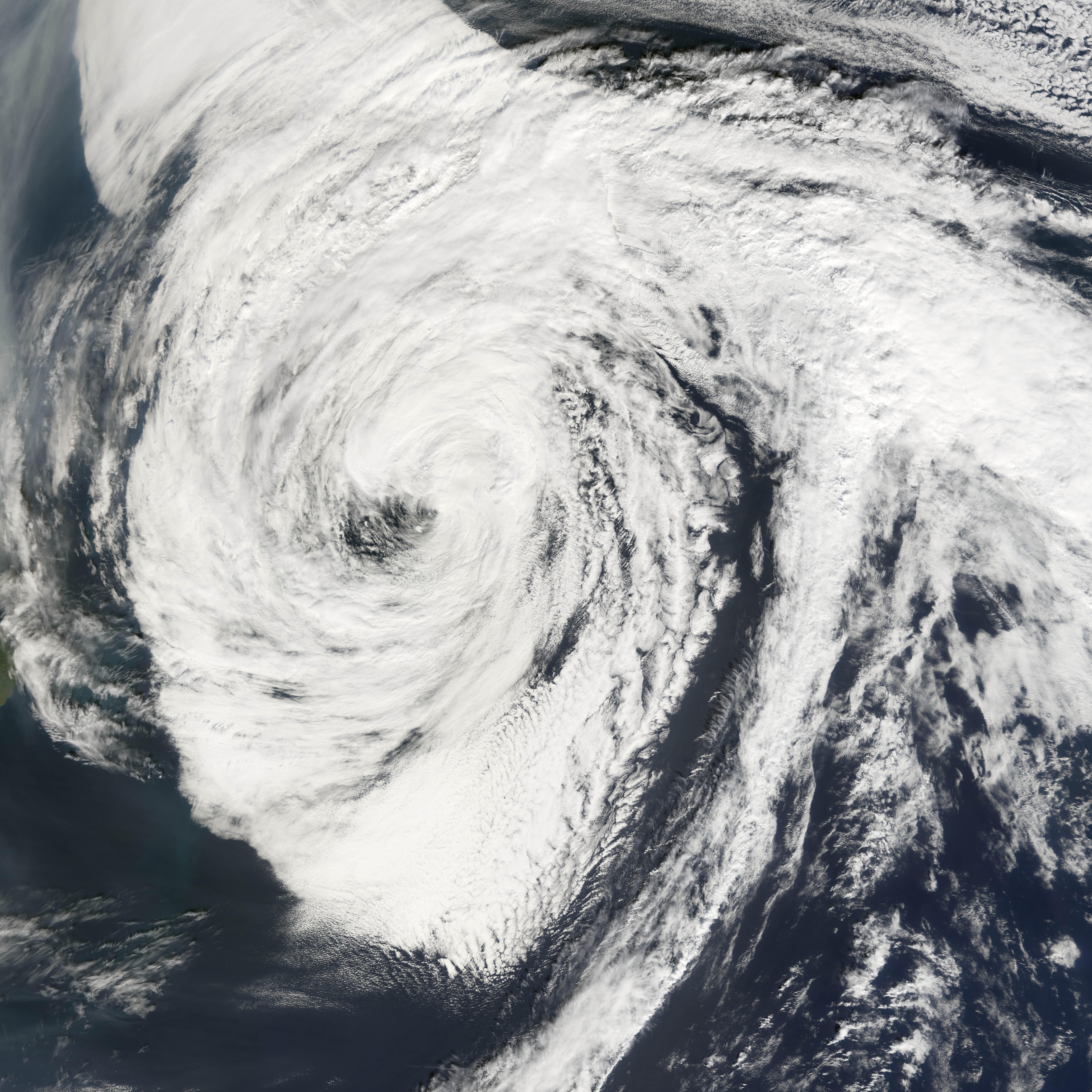
 Hurricane Florence in the north Atlantic after completing its transition to an extratropical cyclone from a hurricane
Tropical cyclones often transform into extratropical cyclones at the end of their tropical existence, usually between 30° and 40° latitude, where there is sufficient forcing from upper-level troughs or shortwaves riding the Westerlies for the process of extratropical transition to begin. During extratropical transition, the cyclone begins to tilt back into the colder airmass with height, and the cyclone's primary energy source converts from the release of latent heat from condensation (from thunderstorms near the center) to baroclinic processes. The low pressure system eventually loses its warm core and becomes a cold-core system. During this process, a cyclone in extratropical transition (known across the eastern North Pacific and North Atlantic oceans as the post-tropical stage)[13][14] will invariably form or connect with nearby fronts and/or troughs consistent with a baroclinic system. Due to this, the size of the system will usually appear to increase, while the core weakens. However, after transition is complete, the storm may re-strengthen due to baroclinic energy, depending on the environmental conditions surrounding the system. The cyclone will also distort in shape, becoming less symmetric with time.
On rare occasions, an extratropical cyclone can transit into a tropical cyclone if it reaches an area of ocean with warmer waters and an environment with less vertical wind shear. The peak time of subtropical cyclogenesis (the midpoint of this transition) is in the months of September and October, when the difference between the temperature of the air aloft and the sea surface temperature is the greatest, leading to the greatest potential for instability. An example of this happening is in the 1991 Halloween Nor'easter. [15] The process known as "tropical transition" involves the usually slow development of an extratropically cold core vortex into a tropical cyclone.[16][17]
Structure
See also: Weather frontsSurface pressure/wind distribution
 QuikSCAT image of typical extratropical cyclones over the ocean. Note the maximum winds are on the outside of the occlusion.
The windfield of an extratropical cyclone constricts with distance in relation to surface level pressure, with the lowest pressure being found near the center, and the highest winds typically just on the cold/poleward side of warm fronts, occlusions, and cold fronts, where the pressure gradient force is highest.[18] The area north and west of the cold and warm fronts connected to extratropical cyclones is known as the cold sector, while the area south and east of its associated cold and warm fronts is known as the warm sector.
The wind flow around a large cyclone is counterclockwise in the northern hemisphere, and clockwise in th[e southern hemisphere, due to the Coriolis effect (this manner of rotation is generally referred to as cyclonic). Near this center, the pressure gradient force (from the pressure at the center of the cyclone compared to the pressure outside the cyclone) and the Coriolis force must be in an approximate balance for the cyclone to avoid collapsing in on itself as a result of the difference in pressure.[19] The central pressure of the cyclone will lower with increasing maturity, while outside of the cyclone, the sea-level pressure is not very low; its typical value is around 1,013 millibars (29.92 inHg), which is the average sea level pressure for Earth. In most extratropical cyclones, the part of the cold front ahead of the cyclone will develop into a warm front, giving the frontal zone (as drawn on surface weather maps) a wave-like shape. Due to their appearance on satellite images, extratropical cyclones can also be referred to as frontal waves early in their life cycle. In the United States, an old name for such a system is "warm wave".[20]
Once a cyclone occludes, a trough of warm air aloft, or "trowal" for short, will be caused by strong southerly winds on its eastern periphery rotating aloft around its northeast, and ultimately northwestern, periphery (also known as the warm conveyor belt), forcing a surface trough to continue into the cold sector on a similar curve to the occluded front. The trowal creates the portion of an occluded cyclone known as its comma head, due to the comma-like shape of the mid-tropospheric cloudiness that accompanies the feature. It can also be the focus of locally heavy precipitation, with thunderstorms possible if the atmosphere along the trowal is unstable enough for convection.[21]
Vertical structure
Extratropical cyclones slant back into colder air masses and strengthen with height, sometimes exceeding 30,000 feet (approximately 9 km) in depth.[22] Above the surface of the earth, the air temperature near the center of the cyclone is increasingly colder than the surrounding environment. These characteristics are the direct opposite of those found in their tropical cyclones; thus, they are sometimes called "cold-core lows".[23] Various charts can be examined to check the characteristics of a cold-core system with height, such as the 700 millibars (20.67 inHg) chart, which is at about 10,000 feet or 3,000 meters in height. Cyclone phase diagrams are used to tell whether a cyclone is tropical, subtropical, or extratropical.[24]
Cyclone evolution
 Norwegian model and Shapiro-Keyser model differences in frontal structure
There are two models of cyclone development and lifecycles in common use—the Norwegian model and the Shapiro-Keyser Model.[25]
Norwegian cyclone model
Of the two theories on extratropical cyclone structure and life cycle, the older is the Norwegian Cyclone Model, developed during World War I. In this theory, cyclones develop as they move up and along a frontal boundary, eventually occluding and reaching a barotropically cold environment.[26] It was developed completely from surface-based weather observations, including descriptions of clouds found near frontal boundaries. This theory still retains merit, as it is a good description for extratropical cyclones over continental landmasses.
Shapiro-Keyser model
A second competing theory for extratropical cyclone development over the oceans is the Shapiro-Keyser model, developed in 1990.[27] Its main differences with the Norwegian Cyclone Model are the fracture of the cold front, treating warm-type occlusions and warm fronts as the same, and allowing the cold front to progress through the warm sector perpendicular to the warm front. This model was based on oceanic cyclones and their frontal structure, as seen in surface observations and in previous projects which used aircraft to determine the vertical structure of fronts across the northwest Atlantic.
Warm seclusion
A warm seclusion is the mature phase of the extratropical cyclone lifecycle. This was conceptualized after the ERICA field experiment of the late 1980s, which produced observations of intense marine cyclones that indicated an anomalously warm low-level thermal structure, secluded (or surrounded) by a bent-back warm front and a coincident chevron-shaped band of intense surface winds.[28] The Norwegian Cyclone Model, as developed by the Bergen School of Meteorology, largely observed cyclones at the tail end of their lifecycle and used the term occlusion to identify the decaying stages.[29]
Warm seclusions may have cloud-free, eye-like features at their center (reminiscent of tropical cyclones), significant pressure falls, hurricane force winds, and moderate to strong convection. The most intense warm seclusions often attain pressures less than 950 millibars (28.05 inHg) with a definitive lower to mid-level warm core structure.[28] A warm seclusion, the result of a baroclinic lifecycle, occurs at latitudes well poleward of the tropics.
As latent heat flux releases are important for their development and intensification, most warm seclusion events occur over the oceans; they may impact coastal nations with hurricane force winds and torrential rain.[27][30] Climatologically, the Northern Hemisphere sees warm seclusions during the cold season months, while the Southern Hemisphere may see a strong cyclone event such as this during all times of the year.
In all tropical basins, except the Northern Indian Ocean, the extratropical transition of a tropical cyclone may result in reintensification into a warm seclusion. For example, Hurricane Maria of 2005 reintensified into a strong baroclinic system and achieved warm seclusion status at maturity (or lowest pressure).[31]
Motion
 A zonal flow regime. Note the dominant west-to-east flow as shown in the 500 hPa height pattern.
 A February 24, 2007 radar image of a large Extratropical cyclonic storm system at its peak over the central United States.
Extratropical cyclones are generally driven, or "steered", by deep westerly winds in a general west to east motion across both the Northern and Southern hemispheres of the Earth. This general motion of atmospheric flow is known as "zonal".[32] Where this general trend is the main steering influence of an extratropical cyclone, it is known as a "zonal flow regime".
When the general flow pattern buckles from a zonal pattern to the meridional pattern,[33] a slower movement in a north or southward direction is more likely. Meridional flow patterns feature strong, amplified troughs and ridges, generally with more northerly and southerly flow.
Changes in direction of this nature are most commonly observed as a result of a cyclone's interaction with other low pressure systems, troughs, ridges, or with anticyclones. A strong and stationary anticyclone can effectively block the path of an extratropical cyclone. Such blocking patterns are quite normal, and will generally result in a weakening of the cyclone, the weakening of the anticyclone, a diversion of the cyclone towards the anticyclones periphery, or a combination of all three to some extent depending on the precise conditions. It is also common for an extratropical cyclone to strengthen as the blocking anticyclone or ridge weakens in these circumstances.[34]
Where an extratropical cyclone encounters another extratropical cyclone (or almost any other kind of cyclonic vortex in the atmosphere), the two may combine to become a binary cyclone, where the vortices of the two cyclones rotate around each other (known as the "Fujiwhara effect"). This most often results in a merging of the two low pressure systems into a single extratropical cyclone, or can less commonly result in a mere change of direction of either one or both of the cyclones.[35] The precise results of such interactions depend on factors such as the size of the two cyclones, their strength, their distance from each other, and the prevailing atmospheric conditions around them.
Effects
General
 Preferred region of snowfall in an extratropical cyclone
Extratropical cyclones can bring mild weather with a little rain and surface winds of 15–30 km/h (10–20 mph), or they can be cold and dangerous with torrential rain and winds exceeding 119 km/h (74 mph),[36] (sometimes referred to as windstorms in Europe). The band of precipitation that is associated with the warm front is often extensive. In mature extratropical cyclones, an area known as the comma head on the northwest periphery of the surface low can be a region of heavy precipitation, frequent thunderstorms, and thundersnows. Cyclones tend to move along a predictable path at a moderate rate of progress. During fall, winter, and spring, the atmosphere over continents can be cold enough through the depth of the troposphere to cause snowfall.
Severe weather
Squall lines, or solid bands of strong thunderstorms, can form ahead of cold fronts and lee troughs due to the presence of significant atmospheric moisture and strong upper level divergence, leading to hail and high winds.[37] When significant directional wind shear exists in the atmosphere ahead of a cold front in the presence of a strong upper level jet stream, tornado formation is possible.[38] Although tornadoes can form anywhere on Earth, the greatest number occur in the Great Plains in the United States, because downsloped winds off the north-south oriented Rocky Mountains, which can form a dryline, aid their development at any strength.
Explosive development of extratropical cyclones can be sudden. The storm known in the UK as the "Great Storm of 1987" deepened to 953 millibars (28.14 inHg) with a highest recorded wind of 220 km/h (137 mph), resulting in the loss of 19 lives, 15 million trees, widespread damage to homes and an estimated economic cost of £1.2 billion (US$2.3 billion).[39]
Although most tropical cyclones that become extratropical quickly dissipate or are absorbed by another weather system, they can still retain winds of hurricane or gale force. In 1954, Hurricane Hazel became extratropical over North Carolina as a strong Category 3 storm. The Columbus Day Storm of 1962, which evolved from the remains of Typhoon Freda, caused heavy damage in Oregon and Washington, with widespread damage equivalent to at least a Category 3. In 2005, Hurricane Wilma began to lose tropical characteristics while still sporting Category 3-force winds (and became fully extratropical as a Category 1 storm). [40]
Climate and general circulation
In the classic analysis by Edward Lorenz (the Lorenz Energy Cycle),[41] extratropical cyclones (so called atmospheric transients) acts as a mechanism in converting potential energy that is created by pole to equator temperature gradients to eddy kinetic energy. In the process, the pole-equator temperature gradient is reduced (i.e. energy is transported poleward to warm up the higher latitudes).
The existence of such transients are also closely related to the formation of the Icelandic and Aleutian Low - the two most prominent general circulation features in the mid- to sub-polar northern latitudes.[42] The two lows are formed by both the transport of kinetic energy and the latent heating (the energy released when water phase changed from vapor to liquid during precipitation) from the extratropical cyclones.
Historic storms
A violent storm during the Crimean War on November 14, 1854 wrecked 30 vessels, and sparked initial investigations into meteorology and forecasting in Europe. In the United States, the Columbus Day Storm of 1962 led to Oregon's lowest measured pressure of 965.5 hPa (28.51 inHg), violent winds, and US$170 million in damage (1964 dollars).[43] A rapidly strengthening storm struck Vancouver Island on October 11, 1984, and inspired the development of moored buoys off the western coast of Canada.[44] The Wahine disaster, New Zealand's most infamous maritime disaster, that caused the death of 53 people occurred during a major extratropical storm. The Braer Storm of January 1993 was the strongest extratropical cyclone known to occur across the northern Atlantic ocean, with a central pressure of 914 millibars (27.0 inHg).[45]
In the Southern Hemisphere, a violent extratropical storm hit Uruguay on August 23–24, 2005, killing 10 people.[46] The system exceeded 100 mph (160 km/h) winds and Montevideo, the 1.5 million inhabitants capital of the county was affected by tropical storm-force winds for over 12 hours and by hurricane-force winds for nearly four hours.[47] Peak gusts were registered at Carrasco International Airport 107 mph (172 km/h) and at the Harbour of Montevideo 116 mph (187 km/h). The lowest reported pressure was 991.7 hPa. Extratropical cyclones are common in this part of the globe during fall, winter and spring months. The winds usually peak to 80–110 km/h, but winds of 116 mph are very uncommon.[47]
See also
- 1991 Perfect Storm
- Columbus Day Storm
- Cyclogenesis
- European windstorm
- Extratropical transition technique
- Nor'easter
- Storm of the Century (1993)
- Subtropical cyclone
- Surface weather analysis
- Thunderstorm
- Thundersnow
- Tropical cyclogenesis
- Tropical cyclone
- Carmen (storm)
- Hurricane Florence (2006)
References
- ^ a b Dr. DeCaria (2005-12-07). "ESCI 241 – Meteorology; Lesson 16 – Extratropical Cyclones via the Internet Wayback Machine". Department of Earth Sciences, Millersville University. Archived from the original on 2008-02-08. http://web.archive.org/web/20080208224320/http://www.atmos.millersville.edu/~adecaria/ESCI241/esci241_lesson16_cyclones.html. Retrieved 2009-06-21.
- ^ Robert Hart and Jenni Evans (2003). "Synoptic Composites of the Extratropical Transition Lifecycle of North Atlantic TCs as Defined Within Cyclone Phase Space" (PDF). American Meteorological Society. http://ams.confex.com/ams/pdfpapers/70524.pdf. Retrieved 2006-10-03.
- ^ Ryan N. Maue (2004-12-07). "Chapter 3: Cyclone Paradigms and Extratropical Transition Conceptualizations". http://www.coaps.fsu.edu/~maue/cyclone_ch3.html. Retrieved 2008-06-15.
- ^ Ian Simmonds and Kevin Keay (February 2000). "Variability of Southern Hemisphere Extratropical Cyclone Behavior, 1958–97". Journal of Climate (American Meteorological Society) 13 (3): 550–561. Bibcode 2000JCli...13..550S. doi:10.1175/1520-0442(2000)013<0550:VOSHEC>2.0.CO;2. ISSN 1520-0442. http://ams.allenpress.com/perlserv/?request=get-document&doi=10.1175%2F1520-0442(2000)013%3C0550:VOSHEC%3E2.0.CO%3B2#I1520-0442-13-3-550-F04. Retrieved 2009-06-21.
- ^ S.K. Gulev, O. Zolina, and S. Grigoriev (2001). "Winter Storms in the Northern Hemisphere (1958–1999) via the Internet Wayback Machine". Climate Dynamics (Science) 17: 795–809. Bibcode 2001ClDy...17..795G. doi:10.1007/s003820000145. Archived from the original on 2007-11-14. http://web.archive.org/web/20071114023844/http://www.co2science.org/scripts/CO2ScienceB2C/articles/V4/N37/C2.jsp. Retrieved 2009-06-21.
- ^ Carlyle H. Wash, Stacey H. Heikkinen, Chi-Sann Liou, and Wendell A. Nuss (February 1990). "A Rapid Cyclogenesis Event during GALE IOP 9". Monthly Weather Review 118 (2): 234–257. Bibcode 1990MWRv..118..375W. doi:10.1175/1520-0493(1990)118<0375:ARCEDG>2.0.CO;2. ISSN 1520-0493. http://ams.allenpress.com/perlserv/?request=get-abstract&doi=10.1175%2F1520-0493(1990)118%3C0234%3AARCEDG%3E2.0.CO%3B2. Retrieved 2008-06-28.
- ^ Jack Williams (2005-05-20). "Bomb cyclones ravage northwestern Atlantic". USA Today. http://www.usatoday.com/weather/tg/wnoreast/wbombs.htm. Retrieved 2006-10-04.
- ^ Glossary of Meteorology (June 2000). "Bomb". American Meteorological Society. http://amsglossary.allenpress.com/glossary/search?id=bomb1. Retrieved 2009-06-21.
- ^ Frederick Sanders and John R. Gyakum (October 1980). "Synoptic-Dynamic Climatology of the "Bomb"" (PDF). Monthly Weather Review 108 (10). http://ams.allenpress.com/archive/1520-0493/108/10/pdf/i1520-0493-108-10-1589.pdf. Retrieved 2006-11-11.[dead link]
- ^ Joseph M. Sienkiewicz, Joan M. Von Ahn, and G. M. McFadden (2005-07-18). "Hurricane Force Extratropical Cyclones" (PDF). American Meteorology Society. http://ams.confex.com/ams/pdfpapers/94332.pdf. Retrieved 2006-10-21.
- ^ U.K. Met Office. "Great weather events - A record-breaking Atlantic weather system". http://www.metoffice.gov.uk/corporate/pressoffice/anniversary/recordlow1986.html. Retrieved 2009-05-26.[dead link]
- ^ BRÜMMER B.; THIEMANN S.; KIRCHGÄSSNER A.; (2000). "A cyclone statistics for the Arctic based on European Centre re-analysis data (Abstract)". Meteorology and atmospheric physics 75 (3–4): 233–250. Bibcode 2000MAP....75..233B. doi:10.1007/s007030070006. ISSN 0177-7971. http://cat.inist.fr/?aModele=afficheN&cpsidt=861335. Retrieved 2006-10-04.
- ^ "Glossary of Hurricane Terms". Canadian Hurricane Center. 2003-07-10. Archived from the original on 2006-10-02. http://web.archive.org/web/20061002040835/http://www.atl.ec.gc.ca/weather/hurricane/hurricanes9.html. Retrieved 2006-10-04.
- ^ National Hurricane Center (2011-07-11). "Glossary of NHC Terms: P". National Oceanic and Atmospheric Administration. http://www.nhc.noaa.gov/aboutgloss.shtml#p. Retrieved 2011-07-23.
- ^ David M. Roth (2002-02-15). "A Fifty year History of Subtropical Cyclones" (PDF). Hydrometeorological Prediction Center. http://www.hpc.ncep.noaa.gov/research/roth/Subpreprint.pdf. Retrieved 2006-10-04.
- ^ Michelle L. Stewart, COAPS, Tallahassee, FL; and M. A. Bourassa (2006-04-25). "Cyclogenesis and Tropical Transition in decaying frontal zones". American Meteorological Society Conference. http://ams.confex.com/ams/27Hurricanes/techprogram/paper_108880.htm. Retrieved 2006-10-24.
- ^ Christopher A. Davis; Lance F. Bosart (2004-11). "The TT Problem - Forecasting the Tropical Transition of Cyclones" (PDF). American Meteorological Society Journals Online. http://ams.allenpress.com/archive/1520-0477/85/11/pdf/i1520-0477-85-11-1657.pdf. Retrieved 2006-10-24.[dead link]
- ^ "WW2010 - Pressure Gradient Force". University of Illinois. 1999-09-02. http://ww2010.atmos.uiuc.edu/(Gh)/guides/mtr/fw/pgf.rxml. Retrieved 2006-10-11.
- ^ "The Atmosphere in Motion". University of Aberdeen. http://www.abdn.ac.uk/~wpe001/meteo/metoh8.pdf. Retrieved 2011-09-11.
- ^ "The Atmosphere in motion: Pressure & mass". Ohio State University. 2006-04-26. Archived from the original on 2006-09-05. http://web.archive.org/web/20060905234506/http://geog-www.sbs.ohio-state.edu/courses/G520/bmark/Lecture+13-Chp9,+Atmosphere+in+motion-P&mass.pdf. Retrieved 2009-06-21.
- ^ St. Louis University (2003-08-04). "What is a TROWAL? via the Internet Wayback Machine". Archived from the original on 2006-09-16. http://web.archive.org/web/20060916052440/http://www.eas.slu.edu/CIPS/Presentations/Conferences/NWA2002/Snow_NWA_02/tsld003.htm. Retrieved 2006-11-02.
- ^ Andrea Lang (2006-04-20). "Mid-Latitude Cyclones: Vertical Structure". University of Wisconsin-Madison Department of Atmospheric and Oceanic Sciences. http://www.aos.wisc.edu/~aalopez/aos101/wk14.html. Retrieved 2006-10-03.
- ^ Robert Hart (2003-02-18). "Cyclone Phase Analysis and Forecast: Help Page". Florida State University Department of Meteorology. http://moe.met.fsu.edu/cyclonephase/help.html. Retrieved 2006-10-03.
- ^ Robert Hart (2006-10-04). "Cyclone phase evolution: Analyses & Forecasts". Florida State University Department of Meteorology. http://moe.met.fsu.edu/cyclonephase/. Retrieved 2006-10-03.
- ^ David M. Roth (2005-12-15). "Unified Surface Analysis Manual" (PDF). Hydrometeorological Prediction Center (NOAA). http://www.hpc.ncep.noaa.gov/sfc/UASfcManualVersion1.pdf. Retrieved 2006-10-11.
- ^ Shaye Johnson (2001-09-25). "The Norwegian Cyclone Model". University of Oklahoma, School of Meteorology. Archived from the original on 2006-09-01. http://web.archive.org/web/20060901163934/http://weather.ou.edu/~metr4424/Files/Norwegian_Cyclone_Model.pdf#search=%22norwegian%20cyclone%20model%22. Retrieved 2006-10-11.
- ^ a b David M. Schultz and Heini Werli (2001-01-05). "Determining Midlatitude Cyclone Structure and Evolution from the Upper-Level Flow". Cooperative Institute for Mesoscale Meteorological Studies. http://www.cimms.ou.edu/~schultz/papers/marwealog.html. Retrieved 2006-10-09.
- ^ a b Ryan N. Maue (2006-04-25). "Warm seclusion cyclone climatology". American Meteorological Society Conference. http://ams.confex.com/ams/27Hurricanes/techprogram/paper_108776.htm. Retrieved 2006-10-06.
- ^ Lars Bärring (2003-12-11). "Wind Throw Damages on Forests - Frequency and Associated Pressure Patterns 1961–1990 and in a Future Climate Scenario". Department of Geography and Ecosystems Analysis, Lund University. http://www.natgeo.lu.se/ex-jobb/exj_97.pdf#search=occlusion. Retrieved 2006-10-30.
- ^ Jeff Masters (2006-02-14). "Blizzicanes". JeffMasters' Blog on Wunderground.Com. http://www.wunderground.com/blog/JeffMasters/comment.html?entrynum=303&tstamp=200602. Retrieved 2006-11-01.
- ^ Richard J. Pasch; Eric S. Blake (2006-02-08). "Tropical Cyclone Report - Hurricane Maria" (PDF). National Hurricane Center (NOAA). http://www.nhc.noaa.gov/pdf/TCR-AL142005_Maria.pdf. Retrieved 2006-10-30.
- ^ Glossary of Meteorology (June 2000). "Zonal Flow". American Meteorological Society. http://amsglossary.allenpress.com/glossary/search?id=zonal-flow1. Retrieved 2006-10-03.
- ^ Glossary of Meteorology (June 2000). "Meridional Flow". American Meteorological Society. http://amsglossary.allenpress.com/glossary/search?id=meridional-flow1. Retrieved 2006-10-03.
- ^ Anthony R. Lupo; Phillip J. Smith (February 1998). "The Interactions between a Midlatitude Blocking Anticyclone and Synoptic-Scale Cyclones That Occurred during the Summer Season". Monthly Weather Review (Department of Earth and Atmospheric Sciences, Purdue University, West Lafayette, Indiana) 126 (2): 502–515. Bibcode 1998MWRv..126..502L. doi:10.1175/1520-0493(1998)126<0502:TIBAMB>2.0.CO;2. ISSN 1520-0493. http://ams.allenpress.com/perlserv/?request=get-document&doi=10.1175%2F1520-0493(1998)126%3C0502:TIBAMB%3E2.0.CO%3B2#S4. Retrieved 2006-10-21.
- ^ B. Ziv; P. Alpert (December 2003). "Theoretical and Applied Climatology - Rotation of mid-latitude binary cyclones: a potential vorticity approach". Theoretical and Applied Climatology (Springer) 76 (3–4): 189–202. Bibcode 2003ThApC..76..189Z. doi:10.1007/s00704-003-0011-x. ISSN 0177-798X. http://www.springerlink.com/content/nhlkqm3ckujgm106/. Retrieved 2006-10-21.
- ^ Joan Von Ahn; Joe Sienkiewicz; Greggory McFadden; (2005-04). "Mariners Weather Log, Vol 49, No. 1". Voluntary Observing Ship Program. http://www.vos.noaa.gov/MWL/april_05/cyclones.shtml. Retrieved 2006-10-04.
- ^ "WW2010 - Squall Lines". University of Illinois. 1999-09-02. http://ww2010.atmos.uiuc.edu/(Gh)/guides/mtr/svr/type/mline/home.rxml. Retrieved 2006-10-21.
- ^ "Tornadoes: Nature's Most Violent Storms". National Severe Storms Laboratory (NOAA). 2002-03-13. http://www.nssl.noaa.gov/NWSTornado/. Retrieved 2006-10-21.
- ^ "The Great Storm of 1987 via the Internet Wayback Machine". Met Office. Archived from the original on 2007-04-02. http://web.archive.org/web/20070402210526/www.metoffice.gov.uk/education/secondary/students/1987.html. Retrieved 2006-10-30.
- ^ Richard J. Pasch; Eric S. Blake;, Hugh D. Cobb III; and David P Roberts (2006-01-12). "Tropical Cyclone Report - Hurricane Wilma" (PDF). National Hurricane Center (NOAA). http://www.nhc.noaa.gov/pdf/TCR-AL252005_Wilma.pdf. Retrieved 2006-10-11.
- ^ Holton, James R. 1992 An introduction to dynamic meteorology / James R. Holton Academic Press, San Diego : http://www.loc.gov/catdir/toc/els032/91040568.html
- ^ Linear Stationary Wave Simulations of the Time-Mean Climatological Flow, Paul J. Valdes, Brian J. Hoskins, Journal of the Atmospheric Sciences 1989 46:16, 2509-2527
- ^ George Taylor and Raymond R. Hatton (1999). The 1962 Windstorm. Oregon State University Press. ISBN 0-87071-467-8. Archived from the original on 2006-09-07. http://web.archive.org/web/20060907010326/http://www.ocs.orst.edu/page_links/extreme_weather/oct_62_windstorm/62_columbus_day.html. Retrieved 2009-06-21.
- ^ S. G. P. Skey and M. D. Miles (1999-11-08). "Advances in Buoy Technology for Wind/Wave Data Collection and Analysis". AXYS Technologies. Archived from the original on 2006-10-18. http://web.archive.org/web/20061018180150/http://www.axystechnologies.com/pdf/techpapers/advances.pdf. Retrieved 2006-11-25.
- ^ Stephen Burt (April 1993). "Another new North Atlantic low pressure record". Weather (Royal Meteorological Society) 48 (4): 98–103.
- ^ NOAA (2009-07-31). "State of the Climate Global Hazards August 2005". National Oceanic and Atmospheric Administration. http://www.ncdc.noaa.gov/sotc/index.php?report=hazards&year=2005&month=aug#Extratropic. Retrieved 2009-09-21.
- ^ a b Gary Padget (2005-07-31). "Monthly Global Tropical Cyclone Summary August 2005". Australian Severe Weather. http://australiasevereweather.com/cyclones/2006/summ0508.htm. Retrieved 2009-09-21.
Cyclones and Anticyclones of the world Types Annual anticyclones Polar high – Siberian High – Azores High (Bermuda/North Atlantic) – North American High (Canadian/Greenland) – South Atlantic High (St.Helena) – North Pacific High – South Pacific High – Scandinavian High – Mascarene High (Indian) – Australian High – Antarctic HighAnnual cyclones Categories:- Extratropical cyclones
- Midlatitude weather
- Tropical cyclone meteorology
- Types of cyclone


Wikimedia Foundation. 2010.