- Denton Municipal Airport
-
Denton Municipal Airport 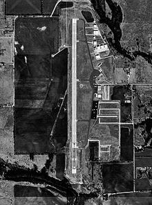
USGS aerial image, 11 January 1996 IATA: none – ICAO: KDTO – FAA LID: DTO Summary Airport type Public Owner City of Denton Serves Denton, Texas Elevation AMSL 642 ft / 195.7 m Coordinates 33°12′03″N 097°11′53″W / 33.20083°N 97.19806°W Runways Direction Length Surface ft m 18/36 7,002 2,134 Asphalt Statistics (2009) Aircraft operations 105,010 Based aircraft 218 Source: Federal Aviation Administration[1] Denton Municipal Airport (ICAO: KDTO, FAA LID: DTO), also known as Denton Airport, is a city-owned public-use airport located three nautical miles (6 km) west of the central business district of Denton, a city in Denton County, Texas, United States.[1]
Although most U.S. airports use the same three-letter location identifier for the FAA and IATA, this airport is assigned DTO by the FAA but has no designation from the IATA.[2]
Contents
History
The airport was established in 1942 and used during 1943-44 by the United States Army Air Forces as a contract glider training airfield. It was known at the time as Denton Field. Harte Flying Service provided instruction. It was used primarily by C-47 Skytrains and Waco CG-4 unpowered Gliders. The mission of the school was to train glider pilot students in proficiency in operation of gliders in various types of towed and soaring flight, both day and night, and in servicing of gliders in the field.
It was inactivated in late 1944 with the drawdown of AAFTC's pilot training program. It was then declared surplus and turned over to the Army Corps of Engineers on 30 September 1945. It was eventually discharged to the War Assets Administration (WAA) and became a civil airport in December 1946.
Facilities and aircraft
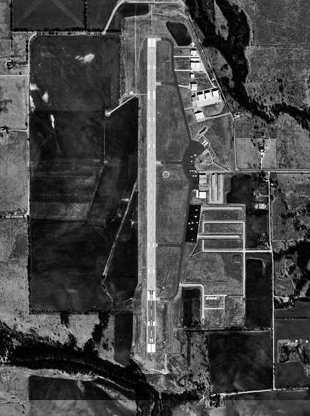
Denton Municipal Airport covers an area of 700 acres (280 ha) at an elevation of 642 feet (196 m) above mean sea level. It has one asphalt paved runway designated 18/36 which measures 7,002 x 150 feet (2,134 x 46 m).[1]
For the 12-month period ending March 7, 2009, the airport had 105,010 aircraft operations, an average of 288 per day. At that time there were 218 aircraft based at the airport: 77% single-engine, 13% multi-engine, and >1% jet, helicopter and glider.[1]
The airport has 3 flight schools:
- US Flight Academy
- All American Helicopters
- Longhorn Helicopters
The airport also has two FBOs:
Additionally, the Hangar 10 Flying Museum is located here.
See also
References
- ^ a b c d FAA Airport Master Record for DTO (Form 5010 PDF), effective 2009-05-07.
- ^ Great Circle Mapper: KDTO - Denton, Texas
- ^
 This article incorporates public domain material from websites or documents of the Air Force Historical Research Agency.
 - ^ Shaw, Frederick J. (2004), Locating Air Force Base Sites History’s Legacy, Air Force History and Museums Program, United States Air Force, Washington DC, 2004.
- ^ Manning, Thomas A. (2005), History of Air Education and Training Command, 1942-2002. Office of History and Research, Headquarters, AETC, Randolph AFB, Texas ASIN: B000NYX3PC
External links
- Denton Airport at City of Denton web site
- FAA Airport Diagram (PDF), effective 20 October 2011
- FAA Terminal Procedures for DTO, effective 20 October 2011
- Resources for this airport:
- AirNav airport information for DTO
- FlightAware airport information and live flight tracker
- SkyVector aeronautical chart for DTO
Airfields in Dallas–Fort Worth–Arlington International Regional Dallas Love Field (DAL)Municipal Addison Airport (ADS) • Airpark East Airport (1F7) • Air Park-Dallas Airport (F69) •Alliance Airport (AFW) • Arlington Municipal Airport (GKY) • Bourland Field (50F) • Collin County Regional Airport at McKinney (TKI) • Kenneth Copeland Airport (4T2) • Denton Municipal Airport (DTO) • Executive Airport (RBD) • Flying C Airport (T87) • Fort Worth Spinks Airport (FWS) • Grand Prairie Municipal Airport (GPM) • Hicks Airfield (T67) • Ironhead Airport (T58) • Lakeview Airport (30F) • Lancaster Airport (LNC) • Lane Field Airport (58F) • Mesquite Metro Airport (HQZ) • Northwest Regional Airport (58F) • Phillips Flying Ranch Airport (T48) • Sycamore Strip Airport (9F9)Military Acme Brick • Ben E. Keith Co. • C. H. Collins Athletic Complex • Courthouse-on-the-Square • Denton Arts and Jazz Festival • Denton ISD • Denton Municipal Airport • DCTA • Denton Regional Medical Center • FEMA • Fouts Field • Golden Triangle Mall • Lake Lewisville • Lake Ray Roberts • Morrison Milling • North Texas State Fair and Rodeo • NUCONSTEEL • Peterbilt Motors • Precision Pattern, Incv • Rayzor Ranch • Sally Beauty Company • Texas Health Presbyterian Hospital Denton • Texas Woman's University • United Copper Industries • University of North Texas • University of North Texas Research Park • UNT Coliseum Army Air Forces Training Command
Flying Training Flying Schools Eastern Flying Training Command · Central Flying Training Command · Western Flying Training CommandSpecialized Schools Bombardier · Contract Flying · Glider Training · Gunnery · Navigator
Technical Training Eastern Technical Training Command · Central Technical Training Command · Western Technical Training CommandCategories:- 1942 establishments
- USAAF Contract Flying School Airfields
- USAAF Glider Training Airfields
- Airfields of the United States Army Air Forces in Texas
- Airports in the Dallas-Fort Worth Metroplex
- Denton, Texas
- Transportation in Denton County, Texas
- Buildings and structures in Denton County, Texas
Wikimedia Foundation. 2010.