- Extreme points of Earth
-
Further information: World record, List of extreme points lists, and Extremes on Earth
This is a list of extreme points of Earth, the points that are farther north, south, east or west than, higher or lower in altitude than, or farthest inland or out to sea from, any other locations on the landmasses, continents or countries.
Contents
- 1 The world
- 2 The Americas
- 3 Antarctica
- 4 The Arctic
- 5 Australasia
- 6 Afro-Eurasia
- 7 See also
- 8 References
The world
Latitude and longitude
- The northernmost point of Earth is the geographic North Pole, in the Arctic Ocean.
- The northernmost point on land is Kaffeklubben Island, north of Greenland (83°40′N 29°50′W / 83.667°N 29.833°W), which lies slightly north of Cape Morris Jesup, Greenland (83°38′N 32°40′W / 83.633°N 32.667°W). Various shifting gravel bars lie further north, the most famous being Oodaaq. The term Ultima Thule was given by medieval cartographers to denote any distant northern place located beyond the "borders of the known world."
- The southernmost point of the world and the southernmost point on land is the geographic South Pole, which is on the continent of Antarctica.
- The westernmost and easternmost points of the world, based on the normal practice of using longitude, can be found anywhere along the 180th meridian in Siberian Russia (including Wrangel Island), Antarctica, or the three islands of Fiji through which the 180th meridian passes (Vanua Levu's eastern peninsula, the middle of Taveuni, and the western part of Rabi.)
- The westernmost point on land, according to the path of the International Date Line, would be Attu Island, Alaska.
- The easternmost point on land, according to the path of the International Date Line, would be Caroline Island, Kiribati.1
1A 1995 realignment of the International Date Line ([4]) moved all of Kiribati to the Asian side of the Date Line, causing Caroline Island to be the easternmost. However, if the previous Date Line were followed, the easternmost point would be Tafahi Niuatoputapu, in the Tonga Islands chain.
Altitude
Highest point
- The highest point measured from sea level is the summit of Mount Everest that borders Nepal and Tibet, and has been reached by roughly 3,000 climbers, the first confirmed in 1953 (with speculation that it may have been reached in 1924). While measurements of its height vary slightly, the elevation of its peak is usually given as 8,848 m (29,029 ft) above sea level.
- The point farthest from the Earth's center is the summit of Chimborazo, in Ecuador, at 6,384.4 km (3,967.1 mi). This is due to the Earth being an oblate spheroid rather than a perfect sphere. An oblate spheroid is very much like a sphere except wider in the center. This means that Chimborazo, which is near the equator, is farther away from the center. The summit of Mount Everest is 2.168 km (1 mi) shorter at 6,382.3 km (3,965.8 mi) from Earth's center. Huascarán contends closely with Chimborazo, the difference in the mountains' heights being less than the 2-kilometre (1 mi) measurement error.[citation needed]
Lowest point (artificial)
- The lowest point underground is the 12,261 metres (40,226 ft)-deep Kola Superdeep Borehole number SG-3 drilled in the Kola Peninsula, Russia. According to Google Maps, it starts from approximately 400 meters above sea level.
- The lowest human-sized point underground is 3.9 kilometres (2.4 mi)[1] below ground at the TauTona Mine, Carletonville, South Africa.
- The lowest point underwater was the 10,680 metres (35,040 ft)-deep (as measured from the subsea wellhead) Deepwater Horizon oil and gas well located in the Gulf of Mexico. The wellhead of this well was an additional 1,259 metres (4,131 ft) underwater for a total distance of 11,939 metres (39,170 ft) as measured from sea level.[2]28°44′12″N 88°23′13″W / 28.736667°N 88.386944°W
Lowest point (natural)
- The lowest known point is Challenger Deep, at the bottom of the Mariana Trench: 10,911 m (35,797 ft) below sea level [5]. This was visited by humans on only one occasion in 1960, and only two other times since then, both by robotic sea-probes in more recent years.
- The lowest point underground is more than 2,000 metres (6,600 ft) under surface. For example the altitude difference in the Voronya Cave between the entrance and the deepest explored point (its depth) is 2,191 ± 20 metres (7,188 ± 66 ft). The lowest point underground has not been explored.
- The lowest point on land not covered by liquid water is the floor of the Bentley Subglacial Trench: 2,555 m (8,383 ft) below sea level. It is however covered by a thick layer of ice. See the Extremes on Earth page. See List of places on land with elevations below sea level
- The lowest point on dry land is the shore of the Dead Sea, shared by Israel and Jordan, 418 m (1,371 ft) below sea level. See List of places on land with elevations below sea level
- The point closest to the Earth's centre (~6,353 km (3,948 mi)) is probably at the bottom of the Arctic Ocean (greatest depth 5,450 m (17,881 ft)) near the Geographic North Pole (the bottom of the Mariana Trench is 6,366.4 km (3,956 mi) from the centre of the Earth).
Highest attainable by transportation
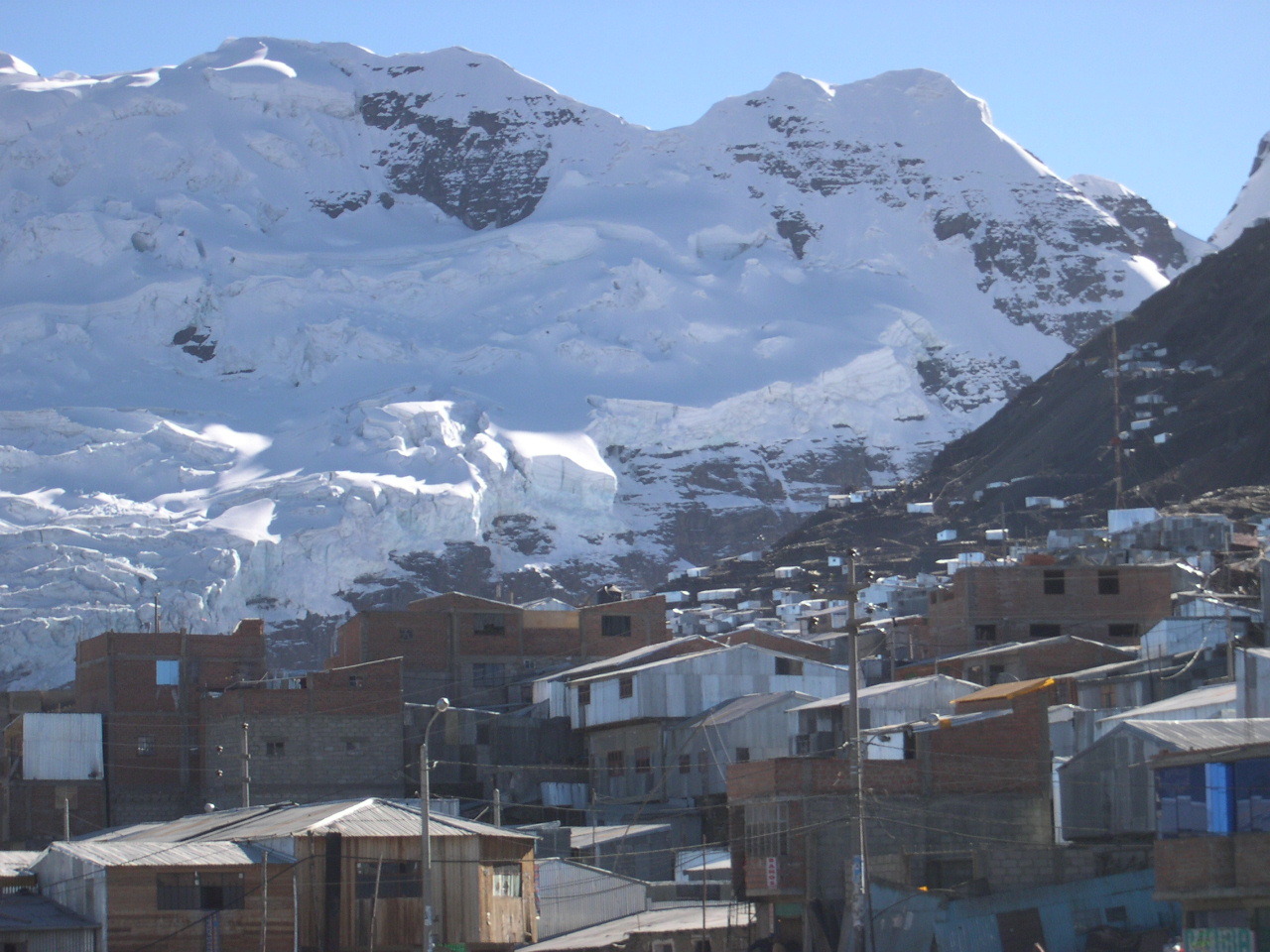
 La Rinconada, Peru
- Road (dead end): Aucanquilcha, Chile, 6,176 m (20,262 ft), mining road to summit of volcano, once usable by 20-ton mining trucks.[3] The road is no longer usable.21°12′50″S 68°28′30″W / 21.214°S 68.475°W
- Road (mountain pass): Possibly Semo La, The People's Republic of China, 5,565 m (18,258 ft), or Marsimik La, India, 5,582 m (18,314 ft), depending on definition of "attainable by transportation". There may be higher motorable passes in Tibet, in areas affected by lack of information and restricted access. See Khardung La, 5,359 m, for more information.
- Train: Tanggula Mountain Pass, in the Tanggula Mountains, The People's Republic of China, 5,072 m (16,640 ft), located on the Qingzang Railway. Tanggula also has the world's highest railway station at 5,068 m (16,627 ft). Before the Qingzang Railway was built, the highest railway ran between Lima and Huancayo in Peru, reaching 4,829 m (15,843 ft) at Ticlio.[4]
- Commercial airport: Qamdo Bangda Airport, The People's Republic of China, 4,334 m (14,219 ft).[5] But Nagqu Dagring Airport, 4,436 m (14,554 ft), currently under construction, will be higher.
- Helipad: Sonam, Siachen Glacier, India at a height of 6,400 m (20,997 ft) above sea level.[6]
- Permanent settlement: La Rinconada, Peru, 5,100 m (16,732 ft), in the Peruvian Andes. It is located near a gold mine.
Lowest attainable by transportation
- Road: The roads beside the Dead Sea, Israel and Jordan, 418 m (1,371 ft) below sea level.
- Commercial airport: Bar Yehuda Airfield (MTZ), near Masada, Isreal, 1,240 ft (378.0 m) below sea level.
- Train: Excluding tracks inside South African gold mines, which can be several thousand metres below sea level, the world's lowest railway is located in Japan's Seikan Tunnel, at 240 m (787 ft) below sea level. By comparison, the Channel Tunnel between Folkestone, England, and Coquelles, France, reaches a depth of 75 m (246 ft). The lowest station is Yoshioka-kaitei, 150 m (492 ft) below sea level. Outside tunnels, the lowest railway is 71 m (233 ft) below sea level, on the line connecting Yuma, Arizona, and Palm Springs, California, in the United States.[4]
Highest geographical features
- Lake: There is an unnamed crater lake on Ojos del Salado (which itself is the world's highest volcano) at 6,390 m (20,965 ft),[7] on the Argentina–Chile border (the lake is in Chile). Another candidate is Lhagba Pool on the northeast slopes of Mount Everest, China at an altitude of 6,368 m (20,892 ft).[8]
- Navigable Lake: Lake Titicaca, on the border of Peru and Bolivia in the Andes, 3,812 m (12,507 ft)
- Glacier: The Khumbu Glacier on the southwest slopes of Mount Everest in Nepal is the world's highest glacier, beginning on the west side of Lhotse at an altitude of 7,600 m (24,934 ft) to 8,000 m (26,247 ft).[9]
- River: One candidate from among many possibilities is the Ating Ho (Ho meaning river), which flows into the Aong Tso (Hagung Tso), a large lake in Tibet, China and is about 6,100 m (20,013 ft) at its source at 32°49′30″N 81°03′45″E / 32.825°N 81.0625°E. A very large high river is the Yarlung Tsangpo or upper Brahmaputra River in Tibet, China whose main stem, the Maquan He has its source at about 6,020 m (19,751 ft) above sea level at 30°48′59″N 82°42′45″E / 30.81639°N 82.7125°E.[10] Above these altitudes there are no rivers since the temperature is almost always below freezing.
- Island: There are a number of islands in the Orba Co lake, which is located at an altitude of 5,209 m (17,090 ft) in Tibet.[11]
Remoteness
Each continent has its own Continental Pole of Inaccessibility, defined as the place on the continent that is farthest from any ocean. Of these continental points, the most remote is the Eurasian Pole of Inaccessibility (or "EPIA") 46°17′N 86°40′E / 46.283°N 86.667°E, in north-western China near the Kazakhstan border. Calculations have commonly suggested that it is 2,645 km (1,645 mi) from the nearest coastline, located in the Dzoosotoyn Elisen Desert. The nearest settlement to the EPIA is Suluk at 46°15′N 86°50′E / 46.25°N 86.833°E about 7 miles (11 km) to the east.[12]
A recent study[13] suggests that the historical calculation of the EPIA has failed to recognize the point where the Gulf of Ob joins the Arctic Ocean, and proposes instead that varying definitions of coastline could result in other Eurasian Pole of Inaccessibility results: EPIA1 somewhere between 44°17′N 82°11′E / 44.283°N 82.183°E and 44°29′N 82°19′E / 44.483°N 82.317°E, about 2510±10 km from the nearest ocean, or EPIA2 somewhere between 45°17′N 88°08′E / 45.283°N 88.133°E and 45°28′N 88°14′E / 45.467°N 88.233°E, about 2514±7 km from the nearest ocean.[13] If adopted, this would place the final EPIA roughly 130 km closer to ocean than currently agreed upon.
Coincidentally, EPIA1 (or EPIA2) and the most remote of the Oceanic Poles of Inaccessibility (specifically, the point in the South Pacific Ocean that is farthest from land) are similarly remote; EPIA1 is less than 200 km closer to the ocean than the Oceanic Pole of Inaccessibility is to land.
Other continents' poles of inaccessibility are as follows:
-
- North America: 43°22′N 101°58′W / 43.36°N 101.97°W,[13] between Kyle and Allen, South Dakota;
- South America: in Brazil at 14°03′S 56°51′W / 14.05°S 56.85°W,[13] near Arenápolis;
- Australia: either 23°2′S 132°10′E / 23.033°S 132.167°E,[14] or 23°10′S 132°16′E / 23.17°S 132.27°E.[13], near Alice Springs;
- Africa: 5°39′N 26°10′E / 5.65°N 26.17°E,[13] close to the tripoint of Central African Republic, South Sudan and Democratic Republic of the Congo, also close to the town of Obo.
- The Pacific pole of inaccessibility (also called Point Nemo), the point in the ocean farthest from any land, lies in the South Pacific Ocean at 48°52.6′S 123°23.6′W / 48.8767°S 123.3933°W, which is approximately 2,688 km (1,670 mi) from the nearest land (equidistant from Ducie Island in the Pitcairn Islands to the north, Maher Island off Siple Island near Marie Byrd Land, Antarctica, to the south and Motu Nui off Rapa Nui in the north east). It is in the middle of an area of 22,405,411 km2 (8,650,778 sq mi) of ocean, larger than the entire former Soviet Union.
- The most remote island is Bouvet Island, an uninhabited and small Norwegian island in the South Atlantic Ocean. It lies at coordinates 54°26′S 3°24′E / 54.433°S 3.4°E. The nearest land is the uninhabited Queen Maud Land, Antarctica, over 1,600 km (994 mi) away to the south. The nearest inhabited land is Tristan da Cunha, 2,260 km (1,404 mi) away and South Africa, 2,580 km (1,603 mi) away.
- The most remote archipelago is Tristan da Cunha in the South Atlantic Ocean, 2,816 km (1,750 mi) from South Africa and 3,360 km (2,090 mi) from South America. The islands are part of the British overseas territory of Saint Helena, Ascension and Tristan da Cunha. With a population of c. 270, the main island of Tristan da Cunha is also the remotest inhabited island in the world.
- The most remote city with a population in excess of one million is Auckland, New Zealand. The nearest city of comparable size or greater is Sydney in Australia, 2,168.9 kilometres (1,347.7 mi) away.[15] Coming in a close second at 2,139 kilometres (air travel distance) is Perth, Australia. Its nearest city of at least one million population is Adelaide, Australia.
- The most remote city with a population in excess of 500,000 is Honolulu, Hawaii, USA. The nearest city of comparable size or greater is San Francisco, 3,841 kilometres (2,387 mi.) away.
- The most remote airport in the world is Mataveri International Airport (IPC) on Easter Island, which has a single runway for military and public use. It is located 3,759 km (2,336 mi) from Santiago, Chile (SCL), which has scheduled flights to it, and 2,603 km (1,617 mi) from Mangareva (GMR) in the Gambier Islands, French Polynesia, which does not have scheduled flights to it.[16] In comparison to this, the airport at the Amundsen-Scott South Pole Station (NZSP) is not very remote at all, being located only 1,355 kilometres (842 mi) from Williams Field (NZWD) near Ross Island.[17]
- The most remote capital city in the world (longest distance from one capital of a sovereign country to the one closest to it) is a tie between Wellington, New Zealand, and Canberra, Australia, which are 2,326 km (1,445 mi) apart from each other. Canberra could drop from this tie as it is only 2,217 km (1,378 mi) from Noumea, New Caledonia,[18], a special territory of France which is scheduled to vote on independence between 2014 and 2019. [19]
Center
Since the Earth is a spheroid, its center (the core) is thousands of kilometres beneath its crust. On the surface, the point 0°, 0°, located in the Atlantic Ocean approximately 614 km south of Accra, Ghana, in the Gulf of Guinea, at the intersection of the Equator and Prime Meridian, at the coordinates of zero degrees by zero, is the "center" of the standard geographic model, as viewed on a map—but this selection of longitude meridian is culturally and historically dependent. The center of population, the place to which there is the shortest average route for everyone in the world, could be considered a centre of the world, and is located in the north of the Indian subcontinent, although the precise location has never been calculated.
Along constant latitude (east-west distances)
- Longest continuous distance on land:
- 10,726 km (6665 mi) at 48°24'53N: France (4°47'44W), central Europe, Ukraine, Russia, Kazakhstan, Mongolia, China, Russia (140°6'3E).[citation needed]
- Longest continuous distance at sea (between continents):
- 15,409 km (9575 mi) at 18°39'12N: China (Hainan) (110°15'9E), Pacific Ocean, Mexico (103°42'6W).[citation needed]
- Longest continuous latitude on land (incl. permanent ice shelf):
- 7,958 km (4946 mi) at 78°35S: Minimum extent of Ross Ice Shelf, Antarctica (subject to change).[citation needed]
- Longest continuous latitude at sea:
- 22,471 km (13964 mi) at 55°59S: South of Cape Horn, South America.
- 4,435 km (2758 mi) at 83°40N: North of Kaffeklubben Island, Greenland (longest in the northern hemisphere).[citation needed]
Along constant longitude (north-south distances)
- Longest continuous distance on land:
- 7,590 km (4,717 mi) at 99°1'30E: Russia (76°13'6N), Mongolia, China, Burma, Thailand (7°53'24N).[citation needed]
- 7,417 km (4,610 mi) at 20°12E: Libya (32°19N), Chad, Central Africa, Congo DR, Angola, Namibia, Botswana, South Africa (34°41'30S). (Longest in Africa).[citation needed]
- 7,098 km (4,412 mi) at 70°2W: Venezuela (11°30'30N), Colombia, Brazil, Peru, Chile, Argentina (52°33'30S). (Longest in western hemisphere and in South America).[citation needed]
- 5,813 km (3,613 mi) at 97°52'30W: Canada (68°21N), USA, Mexico (16°1N). (Longest in North America).[citation needed]
- Longest continuous distance at sea:
- 15,986 km (9,935 mi) at 34°45'45W: Eastern Greenland (66°23'45N), Atlantic Ocean, Antarctica (Filchner Ice Shelf) (77°37S).[citation needed]
- 15,883 km (9,871 mi) at 172°8'30W: Russia (Siberia) (64°45N), Pacific Ocean, Antarctica (Ross Ice Shelf) (78°20S). (Longest in the Pacific Ocean).[citation needed]
Along any great circle
- Longest continuous distance on land[clarification needed]: 13,573 km. It begins on the coastline near Greenville, Liberia (5°2′51.59″N 9°7′23.26″W / 5.0476639°N 9.1231278°W), goes across the Suez Canal and ends at the top of a peninsula approximately 170 km south of the city Ningbo, China 28°17′7.68″N 121°38′17.31″E / 28.2854667°N 121.6381417°E.[citation needed]
- Longest continuous distance at sea: There are several possible ways to travel along a great circle for more than the antipodic length of 19,840 km. Some good examples of such routes would be:
- From the south coast of Balochistan province somewhere near Port of Karachi, Pakistan (25°25′N 66°25′E / 25.417°N 66.417°E) across the Arabian Sea, south-west through Indian Ocean, near Comoros, passing Namaete Canyon, near the South Africa coastline, across the South Atlantic Ocean, then west across Cape Horn, then north-west across the Pacific Ocean, near Easter Island, passing the antipodal point, near Amlia island, through the South Bering Sea and ending somewhere on the east-north coast of Kamchatka, near Ossora (59°38′N 163°24′E / 59.633°N 163.4°E). This route is almost 32,000 km long.[citation needed]
- From the south coast of Hormozgan province, Iran (25°35′N 58°22′E / 25.583°N 58.367°E) across the Gulf of Oman, south-east across the Arabian sea, passing south of Australia and New Zealand, near the Antarctic coastline, then north-east across the South Pacific Ocean, passing the antipodal point and ending on the Mexican south-west coast somewhere near Ciudad Lázaro Cárdenas (17°57′N 101°57′W / 17.95°N 101.95°W). This route is at least 24,500 km long.[citation needed]
- From Invercargill (46°37′S 168°59′E / 46.617°S 168.983°E), New Zealand, across Cape Horn, then off the coast of Brazil close to Recife, passing north of Cape Verde, passing the antipodal point and ending somewhere on the south-west coast of Ireland (52°09′N 6°34′W / 52.15°N 6.567°W). This route is approximately 21,000 km long.[citation needed]
The Americas
- Extreme points of the Americas
- Extreme points of North America
- Extreme points of Canada
- Extreme points of Greenland
- Extreme points of Mexico
- Extreme points of the United States
- Extreme points of U.S. states
- Extreme points of New England
- Extreme Points of Texas
- Extreme points of U.S. states
- Extreme points of Central America
- Extreme points of South America
- Extreme points of Argentina
- Extreme points of Brazil
- Extreme points of Chile
- Extreme points of Peru
- Extreme points of North America
Antarctica
The Arctic
Australasia
- Extreme points of Australia
- Extreme points of Fiji
- Extreme points of Guam
- Extreme points of Kiribati
- Extreme points of the Marshall Islands
- Extreme points of the Federated States of Micronesia
- Extreme points of Nauru
- Extreme points of New Zealand
- Extreme points of Niue
- Extreme points of the Northern Mariana Islands
- Extreme points of Palau
- Extreme points of Tuvalu
Afro-Eurasia
- Afro-Eurasia
- Africa
- Extreme points of Algeria
- Extreme points of Angola
- Extreme points of Benin
- Extreme points of Botswana
- Extreme points of Burkina Faso
- Extreme points of Burundi
- Extreme points of Cameroon
- Extreme points of Cape Verde
- Extreme points of Central African Republic
- Extreme points of Chad
- Extreme points of Comoros
- Extreme points of the Democratic Republic of the Congo
- Extreme points of the Republic of Congo
- Extreme points of Côte d'Ivoire
- Extreme points of Djibouti
- Extreme points of Egypt
- Extreme points of Equatorial Guinea
- Extreme points of Eritrea
- Extreme points of Ethiopia
- Extreme points of Gabon
- Extreme points of the Gambia
- Extreme points of Ghana
- Extreme points of Guinea
- Extreme points of Guinea-Bissau
- Extreme points of Kenya
- Extreme points of Lesotho
- Extreme points of Liberia
- Extreme points of Libya
- Extreme points of Madagascar
- Extreme points of Malawi
- Extreme points of Mali
- Extreme points of Mauritania
- Extreme points of Mauritius
- Extreme points of Morocco
- Extreme points of Mozambique
- Extreme points of Namibia
- Extreme points of Niger
- Extreme points of Nigeria
- Extreme points of Rwanda
- Extreme points of São Tomé and Príncipe
- Extreme points of Senegal
- Extreme points of Seychelles
- Extreme points of Sierra Leone
- Extreme points of Somalia
- Extreme points of South Africa
- Extreme points of Sudan
- Extreme points of Swaziland
- Extreme points of Tanzania
- Extreme points of Togo
- Extreme points of Tunisia
- Extreme points of Uganda
- Extreme points of Western Sahara
- Extreme points of Zambia
- Extreme points of Zimbabwe
- Extreme points of Eurasia
- Extreme points of Asia
- Extreme points of China
- Extreme points of India
- Extreme points of Indonesia
- Extreme points of Iran
- Extreme points of Japan
- Extreme points of Jordan
- Extreme points of the Philippines
- Extreme points of Russia
- Extreme points of Taiwan
- Extreme points of Europe
- Extreme points of the European Union
- Extreme points of Andorra
- Extreme points of Austria
- Extreme points of Belgium
- Extreme points of Bulgaria
- Extreme points of Croatia
- Extreme points of the Czech Republic
- Extreme points of Denmark
- Extreme points of Estonia
- Extreme points of Finland
- Extreme points of France
- Extreme points of Germany
- Extreme points of Greece
- Extreme points of Hungary
- Extreme points of Iceland
- Extreme points of Ireland
- Extreme points of Italy
- Extreme points of Latvia
- Extreme points of Liechtenstein
- Extreme points of Lithuania
- Extreme points of Luxembourg
- Extreme points of Malta
- Extreme points of Moldova
- Extreme points of Montenegro
- Extreme points of Monaco
- Extreme points of the Netherlands
- Extreme points of Norway
- Extreme points of Poland
- Extreme points of Portugal
- Extreme points of Romania
- Extreme points of Russia
- Extreme points of San Marino
- Extreme points of Serbia
- Extreme points of Slovakia
- Extreme points of Slovenia
- Extreme points of Spain
- Extreme points of Sweden
- Extreme points of Switzerland
- Extreme points of Ukraine
- Extreme points of the United Kingdom
- Extreme points of Vatican City
- Extreme points of Asia
- Africa
See also
- The world's most northern city, capital, island etc.
- The world's most southern city, capital, island etc.
- Extremes on Earth
- List of countries by northernmost point
- List of countries by southernmost point
- List of highest towns by country
- Lists of extreme points
- Extreme points of the Commonwealth of Nations
- Several cultures have marked points as Land's End or the End of the World
References
- ^ "TauTona, Anglo Gold - Mining Technology". SPG Media Group PLC. 2009-01-01. http://www.mining-technology.com/projects/tautona_goldmine/. Retrieved 2009-03-02.
- ^ "Transocean's Ultra-Deepwater Semisubmersible Rig Deepwater Horizon Drills World's Deepest Oil and Gas Well". Transocean. http://www.deepwater.com/fw/main/IDeepwater-Horizon-i-Drills-Worlds-Deepest-Oil-and-Gas-Well-419C151.html. Retrieved 2010-06-07.
- ^ McIntyre, Loren (April 1987). "The High Andes". National Geographic (National Geographic Society) 171 (4): 422–460. (includes description and photos of Aucanquilcha summit road and mine)
- ^ a b Bennett, Suzy (October 2003). "Destination Guides - World's highest railway, Peru - Wanderlust Travel Magazine". Wanderlust Magazine. http://www.wanderlust.co.uk/magazine/articles/destinations/a-train-journey-through-the-peruvian-andes. Retrieved 2008-10-10.
- ^ "Boeing News Release: Boeing 757 Now Serves World's Highest-Altitude Airport". http://www.boeing.com/news/releases/1995/news.release.950501.html. Retrieved 2007-09-07.
- ^ "Siachen: The world's highest cold war". CNN. 2002-05-20. http://edition.cnn.com/2002/WORLD/asiapcf/south/05/20/siachen.kashmir/. Retrieved 2010-05-02.
- ^ "Andes Website - Information about Ojos del Salado volcano, a high mountain in South America and the world's highest volcano". http://www.andes.org.uk/peak-info-6000/ojos-info.htm. Retrieved 2007-09-07.
- ^ "The Highest Lake in the World". http://www.highestlake.com/highest-lake-world.html#Lhagba. Retrieved 2007-09-07.
- ^ "ASTER measurement of supraglacial lakes in the Mount Everest region of the Himalaya: The main Khumbu Glacier is about 17 km long with elevations ranging from 4900m at the terminus to 7600m at the source....The 7600m to 8000m elevations are also depicted on numerous detailed topographic maps". http://www.ingentaconnect.com/content/igsoc/agl/2002/00000034/00000001/art00060?crawler=true. Retrieved 2008-11-24.
- ^ "The Mystery of World's highest river and largest Canyon". http://www.100gogo.com/bigben.htm. Retrieved 2007-09-07.
- ^ "Island Superlatives". http://www.worldislandinfo.com/SUPERLATIVESV2.html. Retrieved 2007-09-07.
- ^ [1] Map of the region around the Continental Pole of Inaccessibility, showing relative locations of Hoxtolgay, Xazgat and Suluk, from MSN Maps.
- ^ a b c d e f Garcia-Castellanos, D.; U. Lombardo (2007). "Poles of Inaccessibility: A Calculation Algorithm for the Remotest Places on Earth". Scottish Geographical Journal 123 (3): 227–233. doi:10.1080/14702540801897809. http://cuba.ija.csic.es/~danielgc/papers/Garcia-Castellanos,%20Lombardo,%202007,%20SGJ.pdf. Retrieved 2008.
- ^ Centre of Australia, States and Territories, Geoscience Australia
- ^ Draft Logic - Google Maps Distance Calculator, accessed 4 September 2011
- ^ "Airliners.net: World's Most Remote Airport?". http://www.airliners.net/aviation-forums/general_aviation/read.main/1860487/1/#1. Retrieved 2007-04-23.
- ^ Great Circle Mapper
- ^ [2]
- ^ [3]
Earth-related topics History Geography
and geologyEcology - Earth Day
- Gaia philosophy
- Global warming
- Human impact on the environment
- Millennium Ecosystem Assessment
Imaging Arts, culture
and society- Earth in culture
- Earth in fiction
- Etymology of the word "Earth"
- Flat Earth and Hollow Earth
- History of the world
- International law
- Landscape art
- List of countries
- World economy
Spirituality
and teleology- Creation myth
- Creationism
- Earth Mother
- Gaia (Ancient Greece)
- New Age Gaian
- Planetary Logos (Theosophy)
- Tellus Mater (Ancient Rome)
- Earth sciences portal
- Solar System portal
Categories:

Wikimedia Foundation. 2010.