- Victoria Island (Canada)
Infobox Islands
name = Victoria Island
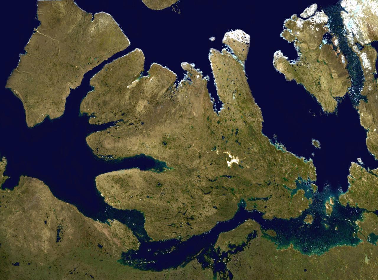
image caption =
image size =
locator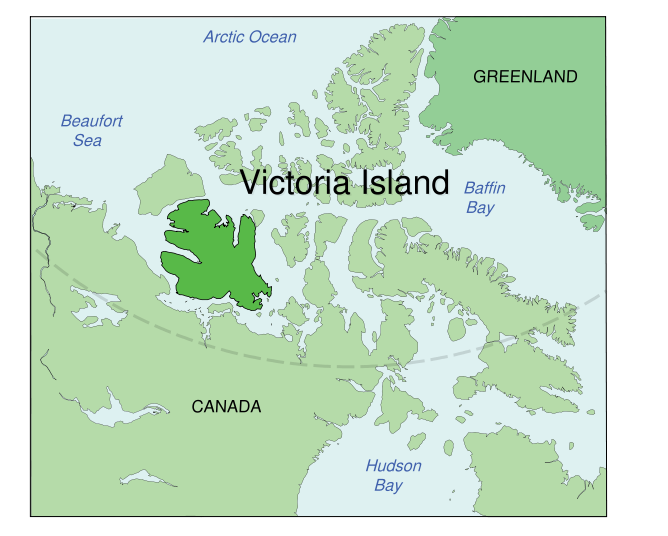
map_custom = no
native name =
native name link =
nickname =
location =Northern Canada
coordinates = coord|71|0|N|110|0|W|display=inline,title|scale:5000000
archipelago =Canadian Arctic Archipelago
total islands =
major islands =
area = convert|217291|km2|sqmi|abbr=on
rank = 8th
highest mount =
elevation =
country = Canada
country admin divisions title = Territories
country admin divisions = flag|Northwest Territories
flag|Nunavut
country capital city =
country largest city = Cambridge Bay
country largest city population = 1,477
population = 1,875
population as of = 2006
density =
ethnic groups =Inuit
additional info =Victoria Island is an island in the
Canadian Arctic Archipelago and straddles the boundary betweenNunavut and theNorthwest Territories ofCanada . It is the 8th largest island of the world, and at convert|217291|km2|sqmi|lk=on|spell=Commonwealth|precision=0fn|1 is Canada's second largest island and nearly double the size of Newfoundland (convert|111390|km2|abbr=on or slightly larger than the island ofGreat Britain (convert|209331|km2|abbr=on. The western third of the island belongs to theInuvik Region in the Northwest Territories and the remainder is part of Nunavut's Kitikmeot Region.Location and description
Viscount Melville Sound lies to the north, and theM'Clintock Channel andVictoria Strait lie eastward. On the west areAmundsen Gulf andBanks Island , which is separated from Victoria by a long sound called thePrince of Wales Strait . To the south (from west to east) lies theDolphin and Union Strait ,Austin Bay ,Coronation Gulf and theDease Strait .The southern waterways, and sometimes the Prince of Wales Strait, form part of the disputed
Northwest Passage which theGovernment of Canada claims areCanadian Internal Waters while other nations state are eitherterritorial waters orinternational waters .Victoria Island is an island of
peninsula s, having a heavily indented coastline with manyinlet s. In the east, pointing northwards, is the Storkerson Peninsula, which ends with theGoldsmith Channel , the body of water separating Victoria fromStefansson Island . The Storkerson Peninsula is separated from the island's north-central areas by Hadley Bay, a major inlet. Another, broad peninsula is found in the north, Prince Albert Peninsula. This ends at the Prince of Wales Strait. In the south, and pointing westwards, is the Wollaston Peninsula, separated from the island's central areas by Prince Albert Sound. The island as a whole coincidentally resembles a stylized maple leaf, the main Canadian symbol.Victoria Island reaches an elevation of m to ft|num=655|abbr=yes|spell=Commonwealth|precision=0|wiki=yes in the
Shaler Mountains in the north-central region. Located in the southeast, just north of Cambridge Bay, is Ferguson Lake with an area of km2 to mi2|num=562|abbr=yes|spell=Commonwealth|precision=0|wiki=no is the largest lake on the island. [ [http://atlas.nrcan.gc.ca/site/english/learningresources/facts/lakes.html#nunavut Ferguson Lake] at the Atlas of Canada]As of the
Canada 2006 Census the population of the island is 1,875; 1,477 in Nunavut and 398 in the Northwest Territories. Of the two settlements on the island the largest is Cambridge Bay, which lies on the south-east coast and is in Nunavut. Ulukhaktok is on the west coast and is in the Northwest Territories.Trading post s, such as Fort Collinson on the northwest coast, have long since been abandoned.The island is named after Queen Victoria, the Canadian sovereign from 1867 to 1901. The features bearing the name "Prince Albert" are, of course, named after her consort.
Although Victoria Island is located in Canada, it is more than 2,000 km from the city of
Victoria, British Columbia , which is onVancouver Island in thePacific Ocean . The island should not be confused with the smaller Victoria Island, also in Nunavut, located inAmadjuak Lake onBaffin Island . [ [http://atlas.nrcan.gc.ca/site/english/maps/topo/map?mapsize=428%20380&lat=64.6667000008&long=-71.4833000008&mapxy=1065346.06556+1908101.72106&scale=5000000&feature_na=Victoria+Island&location1=62&unique_key=0c77edae849c20c3291d18a4d34bf145&searchstring=Victoria%20Island&entity=ISL&layers=fapfeature+fapfeature%20north_arrow%20other_features%20roads%20hydrography%20boundary%20builtup%20vegetation%20populated_places%20railway%20power_network%20manmade_features%20designated_areas%20water_features%20water_saturated_soils%20relief%20contours%20toponymy%20contour%20nodata_ntdb_50k&urlappend=%26unique_key%3D0c77edae849c20c3291d18a4d34bf145%26map.layer%5Btextzoom03%5D%3DFEATURE+POINTS+1064291.56177+1907938.02391+END+TEXT+%22Victoria%2BIsland%22+END%26map.layer%5Btextzoom46%5D%3DFEATURE+POINTS+1064291.56177+1907938.02391+END+TEXT+%22Victoria%2BIsland%22+END%26map.layer%5Bpolygonresultzoom0%5D%3DDATA+fap_islands%26map.layer%5Bpolygonresultzoom1%5D%3DDATA+fap_islands%26map.layer%5Bpolygonresultzoom2%5D%3DDATA+fap_islands%26map.layer%5Bpolygonresultzoom0outline%5D%3DDATA+fap_islands%26map.layer%5Bpolygonresultzoom1outline%5D%3DDATA+fap_islands%26map.layer%5Bpolygonresultzoom2outline%5D%3DDATA+fap_islands%26map.layer%5Barrowzoom03%5D%3DFEATURE+POINTS+1064291.56177+1907938.02391+END+END Victoria Island, Amadjuak Lake] at the Atlas of Canada]Notes

Wikimedia Foundation. 2010.