- Manchester Mayfield railway station
-
Mayfield 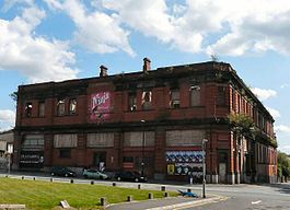
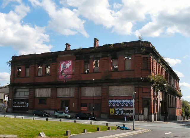
The front of Mayfield station in 2009. Location Place Manchester Area City of Manchester Grid reference SJ851976 Operations Original company London and North Western Railway Pre-grouping London and North Western Railway Post-grouping London, Midland and Scottish Railway
London Midland Region of British RailwaysPlatforms 5 History 8 August 1910 Opened 28 August 1960[1] Closed to passengers 6 July 1970[1] Reopened as a parcel depot 1986 Closed Disused railway stations in the United Kingdom Closed railway stations in Britain
A B C D–F G H–J K–L M–O P–R S T–V W–ZManchester Mayfield is a former railway station in Manchester, England. It is located on the south side of Fairfield Street, next to Manchester Piccadilly station.
Contents
History
Use as a passenger station
 Overgrown station platforms
Opened on 8 August 1910 by the London & North Western Railway,[2] Manchester Mayfield was built alongside Manchester London Road station (later Piccadilly) to handle the increased number of trains and passengers following the opening of the Styal Line in 1909.[3] It was connected to London Road via a high-level footbridge. It was mainly used by suburban services to the south of Manchester, but a number of main line services used it during busy periods.[citation needed]
Mayfield suffered the effects of bombing during World War II, when it was hit by a parachute mine. During the 1950s, the sole passenger usage consisted of the arrival of the Pines Express from Bournemouth West at about 5pm. It came into its own for a brief period during the electrification and modernisation of what was to become Piccadilly Station in the late 1950s, when many services were diverted to it after a restoration of sorts.[citation needed] It was closed to passengers on 28 August 1960.[1]
Use as a goods station
The site was converted into a parcels depot which opened on 6 July 1970.[2] Royal Mail constructed a sorting office on the opposite side of the main line and connected it to Mayfield with an overhead conveyor bridge which crosses the throat of Piccadilly Station. The depot closed in 1986 following the decision by Parcelforce, Royal Mail's parcels division, to abandon rail transport in favour of road haulage.[3] The building has remained disused ever since,[4] with the tracks into Mayfield removed in 1989 as part of the remodelling of the Piccadilly Station layout. The sorting office was briefly reused as an indoor karting track, but has now been rebuilt as prestige offices; the parcel conveyor bridge was removed in 2003.[3]
Disuse
The site is currently owned by BRB Residuary.[5] The interior of the station was used in Prime Suspect as a drug dealer's haunt.[2] It was also used as a double for Sheffield railway station in The Last Train. The roadside building was gutted by a fire in 2005.[2]
Future
Reopening as a station
 Interior showing 1910 buffer stops.
A study was carried out by Mott Macdonald in 2000 which looked at possibilities of increasing capacity at the Piccadilly Station. One solution put forward would see the track quadrupled between Slade Lane Junction and Piccadilly, with a pair of through platforms in the Mayfield goods yard to the south of Piccadilly's platforms 13 and 14 linked to additional running lines to Ashburys station. This proposal was supported by the GMPTE as it would increase usable train paths through Piccadilly by between 33% and 50%; the extra track would, however, require an expensive extension to the Piccadilly-Deansgate viaduct carrying the track from Slade Lane.[6] The location of the proposed platforms was also criticised as it would entail "a long walk for passengers wishing to interchange with other terminating rail services at Manchester Piccadilly or access the city centre."[7]
Other options would have the station used again as a terminus, providing a rail link to Manchester Airport[8] or, alternatively, the lines might be extended through Mayfield and connected to the existing line to Manchester Oxford Road railway station.[2]
Commercial redevelopment
 Station interior.
In 2008 an alternative scheme involving Manchester Mayfield was put forward. This proposal would see the station as part of a new 30-acre (120,000 m2) city centre district to be created immediately next to Piccadilly Station. This project would create over 6,000,000 square feet (560,000 m2) of offices contained in office blocks up to 12 storeys high, and would be completed over a period of 15 years. The scheme is led by "Mayfield Manchester", a joint venture company between Ringset, part of the Wrather Group, and Panamint; the company owns around 90% of the land around the station as of 2008, but do not own the station itself.[4] The future of the former railway station has yet to be decided and Mayfield Manchester were, as of April 2008, said to be in talks with its owners, BRB Residuary.
Conversion into coach station
It has been reported that the station could eventually be converted into a new National Express coach station which would be relocated from its existing facility on Chorlton Street and rebuilt on the western end of the Mayfield Goods Yard with pedestrian links to Piccadilly. A new coach station would be adjacent to the Inner Ring Road and have easy access to the road network.[5][9]
Government offices
In a proposal floated in May 2009, the Labour government were said to have earmarked the site as the location of a 700,000 sq ft (65,000 m2). "super-campus" to house 5,000 civil servants. The construction of the building would, if approved by the Treasury, commence in 2012–2013, and require the demolition of Mayfield station.[10][11]
References
- ^ a b c Clinker, C.R. (October 1978). Clinker's Register of Closed Passenger Stations and Goods Depots in England, Scotland and Wales 1830–1977. Bristol: Avon-AngliA Publications & Services. p. 92. ISBN 0-905466-19-5.
- ^ a b c d e "Subterranea Britanica: SB-Sites: Manchester Mayfield Station". 6 January 2006. http://www.subbrit.org.uk/sb-sites/stations/m/manchester_mayfield/index.shtml. Retrieved 2008-04-25.
- ^ a b c North Wales Railway Notice Board.
- ^ a b Binns, Simon (14 April 2008). "Office scheme backers yet to drop anchor". Crain's Manchester Business. http://www.crainsmanchesterbusiness.co.uk/apps/pbcs.dll/article?AID=/20080414/FREE/429238759/-1/Breaking/-/-/office-scheme-backers-yet-to-drop-anchor. Retrieved 2008-04-24.
- ^ a b Thame, David (8 April 2008). "New district planned". Manchester Evening News. http://www.manchestereveningnews.co.uk/news/business/commercial_property_news/s/1044261_new_district_planned. Retrieved 2008-04-25.[dead link]
- ^ GMPTE Letter to the Rail Regulator, 26 June 2000.
- ^ Steer Davies Gleave, Manchester Hub Report, August 2007.
- ^ Freccles, "North West Route Utilisation Strategy".
- ^ GMPTA, "Regional Centre Transport Strategy Consultation Report", December 2007.
- ^ Ottewell, David (1 May 2009). "Whitehall of the north". Manchester Evening News. http://www.manchestereveningnews.co.uk/news/s/1112985_whitehall_of_the_north. Retrieved 2009-05-15.
- ^ "Plans made for city 'Whitehall'". BBC News. 1 May 2009. http://news.bbc.co.uk/2/hi/uk_news/england/manchester/8028291.stm. Retrieved 2009-07-24.
External links
- Mayfield interior pictures can be seen here
- Photographs of the interior of the building
Manchester Lines - City Centre and North, (Past, Present and Future) LegendTo Bury 


To Rochdale Moston 


To Oldham Bowker Vale 


Newton Heath 


Newton Heath and Moston 

Crumpsall 


Central Park 

To Tameside Abraham Moss;Monsall Clayton Bridge Woodlands Road Park Queens Road 


To Tameside Miles Platting 
Edge Lane 


Clayton Oldham Road 
Sportcity-Velodrome Manchester Victoria 


Holt Town/Sportcity-Stadium Exchange 

To Salford 
New Islington 


Ardwick Exchange Square/Shudehill 

Ashburys High Street; Manchester Piccadilly 


Mayfield;To South Manchester Market Street; Piccadilly Gardens 


To Belle Vue;Gorton Moseley Street;Oxford Road 


To Hyde Road St Peter's Square To Tameside Manchester Central/Deansgate-Castlefield 

Deansgate Liverpool Road 


To Salford;Cornbrook Cornbrook 


Pomona To Eccles 

Trafford Bar To Trafford 


Firswood To Trafford;To Altrincham 
To Chorlton Categories:- Disused railway stations in Manchester
- Former London and North Western Railway stations
- Railway stations opened in 1910
- Railway stations closed in 1986


Wikimedia Foundation. 2010.