- Doña Ana County, New Mexico
-
Doña Ana County, New Mexico 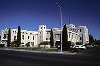 Doña Ana County courthouse in Las Cruces, New Mexico
Seal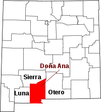
Location in the state of New Mexico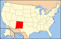
New Mexico's location in the U.S.Founded 1852 Seat Las Cruces Largest city Las Cruces Area
- Total
- Land
- Water
3,815 sq mi (9,881 km²)
3,807 sq mi (9,860 km²)
7 sq mi (18 km²), 0.20%Population
- (2010)
- Density
209,233
57/sq mi (22/km²)Website www.donaanacounty.org Doña Ana County is a county located in the U.S. state of New Mexico. As of the 2010 Census, the population was 209,233.[1] Its county seat is Las Cruces,[2] also the largest city in the county and second-largest in New Mexico. Smaller towns in the county include Mesilla, Doña Ana, Hatch, and Organ. Doña Ana is pronounced Doñana.[3]
Contents
Geography
According to the U.S. Census Bureau, the county has a total area of 3,815 square miles (9,880.8 km2), of which 3,807 square miles (9,860.1 km2) is land and 7 square miles (18.1 km2) (0.20%) is water. The county contains a number of prominent geographical features, most notably the Mesilla Valley (the flood plain of the Rio Grande river) going north to south through the center and the Organ Mountains along the county's eastern edge. Other mountain ranges in the county are the Robledo Mountains, Doña Ana Mountains, Sierra de las Uvas, the southern end of the San Andres Mountains, East Potrillo Mountains, and West Potrillo Mountains, as well as two small, isolated mountains, Tortugas (or A) Mountain on the east and Picacho Peak on the west side of Las Cruces. The county also includes one of New Mexico's four large lava fields, the Aden Malpais, and one of the world's largest maare volcanoes, Kilbourne Hole.
Adjacent counties and municipios
- Luna County, New Mexico - west
- Sierra County, New Mexico - north
- Otero County, New Mexico - east
- El Paso County, Texas - southeast
- Ascensión, Chihuahua, Mexico - south
- Juárez, Chihuahua, Mexico - south
National protected areas
- Prehistoric Trackways National Monument
- San Andres National Wildlife Refuge
- White Sands National Monument (part)
Demographics
Historical populations Census Pop. %± 2000 174,682 — 2010 209,233 19.8% 2010
Whereas according to the 2010 U.S. Census Bureau:
- 74.1% White
- 1.7% Black
- 1.5% Native American
- 1.1% Asian
- 0.1% Native Hawaiian or Pacific Islander
- 3.0% Two or more races
- 18.5% Other races
- 65.7% Hispanic or Latino (of any race)
2000
As of the census[4] of 2000, there were 174,682 people, 59,556 households, and 42,939 families residing in the county. The population density was 46 people per square mile (18/km²). There were 65,210 housing units at an average density of 17 per square mile (7/km²). The racial makeup of the county was 67.82% White, 1.56% Black or African American, 1.48% Native American, 0.76% Asian, 0.07% Pacific Islander, 24.74% from other races, and 3.58% from two or more races. 63.35% of the population were Hispanic or Latino of any race.
There were 59,556 households out of which 38.40% had children under the age of 18 living with them, 52.40% were married couples living together, 14.70% had a female householder with no husband present, and 27.90% were non-families. 21.30% of all households were made up of individuals and 6.90% had someone living alone who was 65 years of age or older. The average household size was 2.85 and the average family size was 3.36.
In the county the population was spread out with 29.70% under the age of 18, 13.30% from 18 to 24, 27.10% from 25 to 44, 19.30% from 45 to 64, and 10.60% who were 65 years of age or older. The median age was 30 years. For every 100 females there were 96.50 males. For every 100 females age 18 and over, there were 93.50 males.
The median income for a household in the county was $29,808, and the median income for a family was $33,576. Males had a median income of $27,215 versus $20,883 for females. The per capita income for the county was $13,999. 25.40% of the population and 20.20% of families were below the poverty line. Out of the total people living in poverty, 34.40% are under the age of 18 and 12.70% are 65 or older.
Politics
Presidential election results Year GOP DEM Others 2008 40.5% 28,068 58.1% 40,282 1.3% 930 2004 47.7% 29,548 51.3% 31,762 1.0% 650 2000 45.6% 21,263 51.3% 23,912 3.2% 1,478 1996 40.3% 17,541 52.3% 22,766 7.5% 3,257 1992 36.9% 16,308 45.0% 19,894 18.2% 8,015 1988 51.7% 21,582 47.0% 19,608 1.3% 557 1984 60.9% 22,153 38.1% 13,878 1.0% 362 1980 53.9% 15,539 37.6% 10,839 8.5% 2,442 1976 53.1% 13,888 46.0% 12,036 0.9% 233 1972 59.8% 14,562 38.6% 9,416 1.6% 388 1968 54.1% 10,824 38.3% 7,658 7.6% 1,508 1964 40.3% 7,280 59.4% 10,748 0.3% 57 1960 46.5% 7,789 53.1% 8,905 0.4% 61 Doña Ana is a Democratic-leaning county in Presidential and Congressional elections. Since 1920, Doña Ana has voted for the candidate who also won statewide, the only exception being in 2004 when Democrat John Kerry won Doña Ana 51-48%, while Republican George W. Bush won statewide 50-49%. The last Republican to win a majority in the county was George H.W. Bush in 1988. In 2008, Democrat Barack Obama won 58% of the county's vote.
Doña Ana is part of New Mexico's 2nd congressional district, which is held by Republican Steve Pearce. In the State Senate Doña Ana is part of the 31st, 36th, 37th, 38th, and 40th Senate districts, which are held by Democrats Cynthia Nava, Mary Jane Garcia, Stephen Fischmann, Mary Kay Papen, and Republican Bill Burt, respectively. In the State House Doña Ana is part of the 33rd, 34th, 35th, and 52nd House districts, which are held by Democrats Joni Gutierrez, Mary Helen Garcia, Antonio Lujan, and Joseph Cervantes, respectively, the 37th and 53rd House districts, which are held by Republicans Terry McMillan and Ricky Little, respectively, and the 36th House district, which is held by Independent Andrew Nunez.
Localities
 Map of Doña Ana County
Cities
Town
Village
Census-designated places
- Chaparral
- Doña Ana
- La Mesa
- Mesquite
- Radium Springs
- Rincon
- Salem
- Santa Teresa
- University Park
- Vado
- White Sands
Other localities
- Organ is a former town and current post office (ZIP code 88052) located 10 miles northeast of Las Cruces on U.S. Route 70.
See also
References
- ^ http://2010.census.gov/2010census/data/
- ^ "Find a County". National Association of Counties. http://www.naco.org/Counties/Pages/FindACounty.aspx. Retrieved 2011-06-07.
- ^ http://aces.nmsu.edu/academics/rangescienceherbarium/documents/22.pdf
- ^ "American FactFinder". United States Census Bureau. http://factfinder.census.gov. Retrieved 2008-01-31.

Sierra County Luna County 
Otero County  Doña Ana County, New Mexico

Ascensión, Chihuahua, Mexico and Juárez, Chichuhua, Mexico El Paso County, Texas Municipalities and communities of Doña Ana County, New Mexico Cities 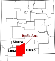
Town Village CDPs Chaparral | Doña Ana | Mesquite | Radium Springs | Rincon | Salem | Santa Teresa | University Park | Vado | White Sands
Other
communitiesBerino | Organ
Ghost town Lanark
Las Cruces, New Mexico 
Suburbs Doña Ana | Mesilla | University Park Doña Ana County New Mexico State University  State of New Mexico
Topics Delegations · Geography · Government · History · Landmarks · Military · Natural history · New Mexicans · Settlements · Transportation · Tribes · Visitor attractions
Society Culture · Demographics · Economy · Education · Politics
Regions Cities Alamogordo · Albuquerque · Artesia · Carlsbad · Clovis · Corrales · Deming · Española · Farmington · Gallup · Grants · Hobbs · Las Cruces · Las Vegas · Los Alamos · Los Lunas · Lovington · Portales · Raton · Rio Rancho · Roswell · Ruidoso · Santa Fe · Silver City · Socorro · Sunland Park · Taos · Tucumcari
Counties Bernalillo · Catron · Chaves · Cibola · Colfax · Curry · De Baca · Doña Ana · Eddy · Grant · Guadalupe · Harding · Hidalgo · Lea · Lincoln · Los Alamos · Luna · McKinley · Mora · Otero · Quay · Rio Arriba · Roosevelt · Sandoval · San Juan · San Miguel · Santa Fe · Sierra · Socorro · Taos · Torrance · Union · Valencia
Coordinates: 32°18′44″N 106°46′42″W / 32.31222°N 106.77833°W
Categories:- New Mexico counties
- Doña Ana County, New Mexico
- 1852 establishments in the United States
- Counties of the United States with Hispanic majority populations


Wikimedia Foundation. 2010.