- Gorky Reservoir
-
Gorky Reservoir 
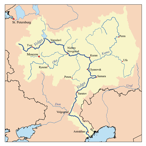
Coordinates 57°00′N 43°10′E / 57°N 43.167°ECoordinates: 57°00′N 43°10′E / 57°N 43.167°E Lake type Hydroelectric reservoir Primary inflows Volga Basin countries Russia Max. length 430 km Max. width 16 km Surface area 1591 km² Max. depth 22 m Water volume 12.9 km³ Surface elevation 84 m Settlements Yaroslavl, Kostroma, Kineshma, Yuryetets Gorky Reservoir (Russian: Го́рьковское водохрани́лище) is an artificial lake in the central part of the Volga River formed by a hydroelectric dam of Gorky Hydroelectric Station (now called Nizhny Novgorod Hydroelectric Station) built in 1955 between the towns of Gorodets and Zavolzhye and filled in 1955 – 1957. It spans for 430 km from the dam of Rybinsk to the dam of Gorodets through Yaroslavl, Kostroma, Ivanovo and Nizhny Novgorod oblasts of Russia. While it is relatively narrow and follows the natural riverbed of Volga in the upper part, it becomes up to 16 km wide downstream the town of Yuryevets.
The reservoir takes its name from the former name of the city of Nizhny Novgorod (actually situated some fifty kilometers downstream the dam), Gorky. An industrial town of Zavolzhye was built on the right bank of the Volga along with the construction of the dam.
The filling of the reservoir resulted in the relocation of a number of villages and towns, such as Chkalovsk.
Volga River Tributaries Selizharovka · Vazuza · Tvertsa · Shosha · Dubna · Medveditsa · Nerl · Kashinka · Sit' · Mologa · Suda · Sheksna · Sogozha · Kotorosl · Kostroma · Nyomda · Unzha · Uzola · Oka · Kudma · Kerzhenets · Sura · Vetluga · Rutka · Tsivil · Great Kokshaga · Little Kokshaga · Anish · Ilet · Sviyaga · Sumka · Kazanka · Kama · Aktay · Bezdna · Cheremshan · Sok · Samara · Chapayevka · Little Irgiz · Irgiz · Tereshka · Yeruslan · Akhtuba (distributary)
Reservoirs Hydroelectric
stationsCanals Categories:- Volga basin
- Ivanovo Oblast
- Kostroma Oblast
- Nizhny Novgorod Oblast
- Yaroslavl Oblast
- Reservoirs in Russia
- Central Russia geography stubs
- Nizhny Novgorod Oblast geography stubs

Wikimedia Foundation. 2010.