- Mid-Atlantic Regional Spaceport
-
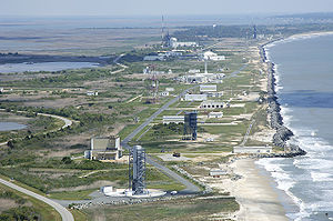 An aerial view of the launch pads at the Mid-Atlantic Regional Spaceport and NASA's Wallops Flight Facility
The Mid-Atlantic Regional Spaceport (MARS) is a commercial space launch facility located at the southern tip of NASA's Wallops Flight Facility on the Delmarva Peninsula south of Chincoteague, Virginia.
Background
In July 2003, Governors Robert Ehrlich of Maryland and Mark Warner of Virginia signed an agreement that directed the Secretary of Commerce and Trade of Virginia and the Secretary of Business and Economic Development of Maryland to form a working group to develop a concept and implementation plan for joint governance, operation and administration of the commercial spaceport at Wallops Island. The spaceport, then known as the Virginia Space Flight Center, had been developed, with a combination of federal, state and private sector funding, by the Virginia Commercial Space Flight Authority (VCSFA).
Launch history
The first rocket to be launched from MARS was an Orbital Sciences Minotaur, at 12:00 GMT on 16 December 2006, with two spacecraft, TacSat-2 for the US Air Force, and GeneSat-1 for NASA.[citation needed]
Launch Date (UTC) Vehicle Payload Launch pad Result Remarks 1 December 16, 2006 12:00 Minotaur I TacSat-2 / GeneSat-1 Pad 0B Success[citation needed] 2 April 24, 2007 06:48 Minotaur I NFIRE Pad 0B Success 3 August 22, 2008 09:10 ATK ALV X-1 Hy-BoLT and SOAREX VI Pad 0B Failure Went off-course, destroyed by range safety 4 May 19, 2009, 19:55 Minotaur I TacSat-3 Pad 0B Success[citation needed] 5 June 30, 2011 03:09 Minotaur I USAF ORS-1 Satellite Pad 0B Success Scheduled launches December 2011 Taurus II COTS Demo Mission Pad 0A Updated: 2011-05-07 2012 Taurus II 2 ISS re-supply missions Pad 0A Updated: 2011-05-07 May 2013 Minotaur V LADEE Pad 0B Updated: 2011-01-03 2013 Taurus II 2 ISS re-supply missions Pad 0A Updated: 2011-01-03 2014 Taurus II 2 ISS re-supply missions Pad 0A Updated: 2011-01-03 2015 Taurus II 2 ISS re-supply missions Pad 0A Updated: 2011-01-03 Links
Coordinates: 37°50′00″N 75°29′00″W / 37.833378°N 75.483284°W
- Mid-Atlantic Regional Spaceport Launch Pad 0
- Mid-Atlantic Regional Spaceport web site
- Mid-Atlantic Regional Spaceport Implementation Plan, April 2004
- Wallops Flight Facility site
- Orbital Sciences Corporation
- 2010 in spaceflight
- 2011 in spaceflight
- 2012 in spaceflight
Wallops Island launch sites Wallops Flight Facility
Mid-Atlantic Regional SpaceportLA-0 • LA-1 • LA-2 • LA-3 • LA-4 • LA-5Wallops Research Airport • Wallops Island drop zoneSpaceports Asia and the
Middle EastEurope  FKA: Kapustin Yar · Plesetsk ·
  SSC: Esrange
North America  CAF / CSA: Fort Churchill ·
  NASA: KSC · Wallops · DoD: Cape Canaveral (ER) · Vandenberg (WR) · Private: Corn Ranch · Jacksonville · Kodiak · Mid-Atlantic Regional Spaceport · Mojave · Oklahoma · Spaceport America
South America  FAB / AEB: Barreira do Inferno · Alcântara ·
  Private: Spaceport Curaçao ·
  ESA / CNES: Guiana/Kourou
Pacific Categories:- Spaceports
- Space stubs

Wikimedia Foundation. 2010.