- Crib Goch
-
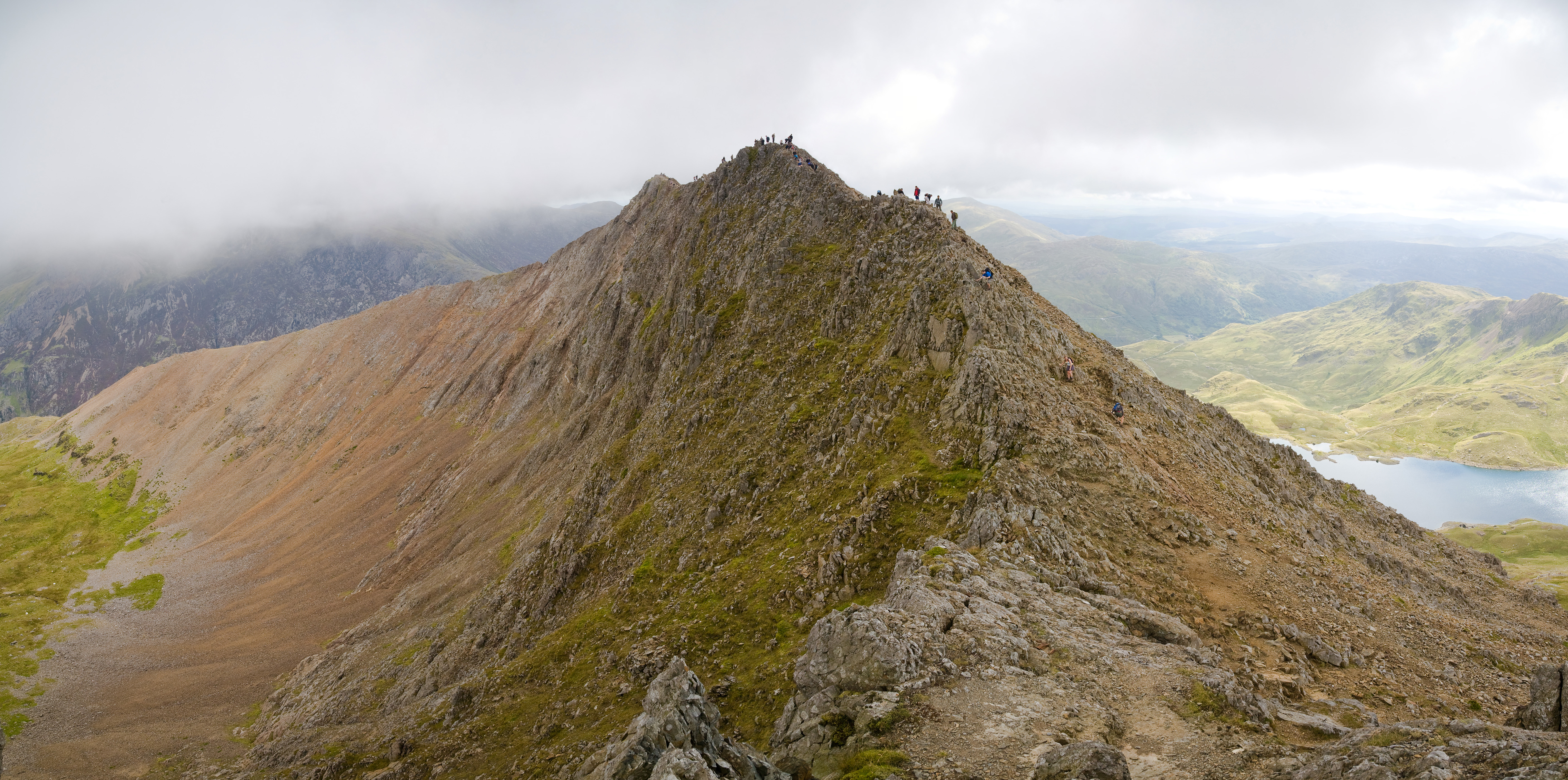
Crib Goch 
Crib Goch from the westElevation 923 m (3,028 ft) Prominence 65 m (213 ft) Parent peak Garnedd Ugain Listing Hewitt, Welsh 3000s, Nuttall Translation red ridge (Welsh) Pronunciation Welsh: [ˈkɾɪb ˈɡox] Location Location Gwynedd, Wales Range Snowdonia Coordinates 53°04′32″N 4°03′13″W / 53.0755422°N 4.053513°WCoordinates: 53°04′32″N 4°03′13″W / 53.0755422°N 4.053513°W Topo map OS Landranger 115 OS grid SH624551 Climbing Easiest route Grade 1 scramble [1]  Part of the Crib Goch ridge. An easy section of the path runs over the grassy saddle
Crib Goch is described as a "knife-edged" arête in the Snowdonia National Park in Gwynedd, Wales. The name means red comb in the Welsh language, presumably referring to the serrated ridge and the colour of some of the rocks.
The highest point on the arête is 923 metres (3,028 ft) above sea level. All routes which tackle Crib Goch are considered mountaineering routes in winter or scrambles in summer—meaning that they must cross "graded territory" as defined in Steve Ashton's "Scrambles in Snowdonia".[2] The easiest of these lines (the "bad step" part of the route) is given a scrambling grade of Grade 1 (the most difficult being Grade 3—routes more difficult than Grade 3 are considered rock climbs).
Contents
Route
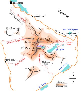 Sketch map of the King Snowdon massif
Legend
·grey: ridges
·red lines: paths
·orange lines: roads
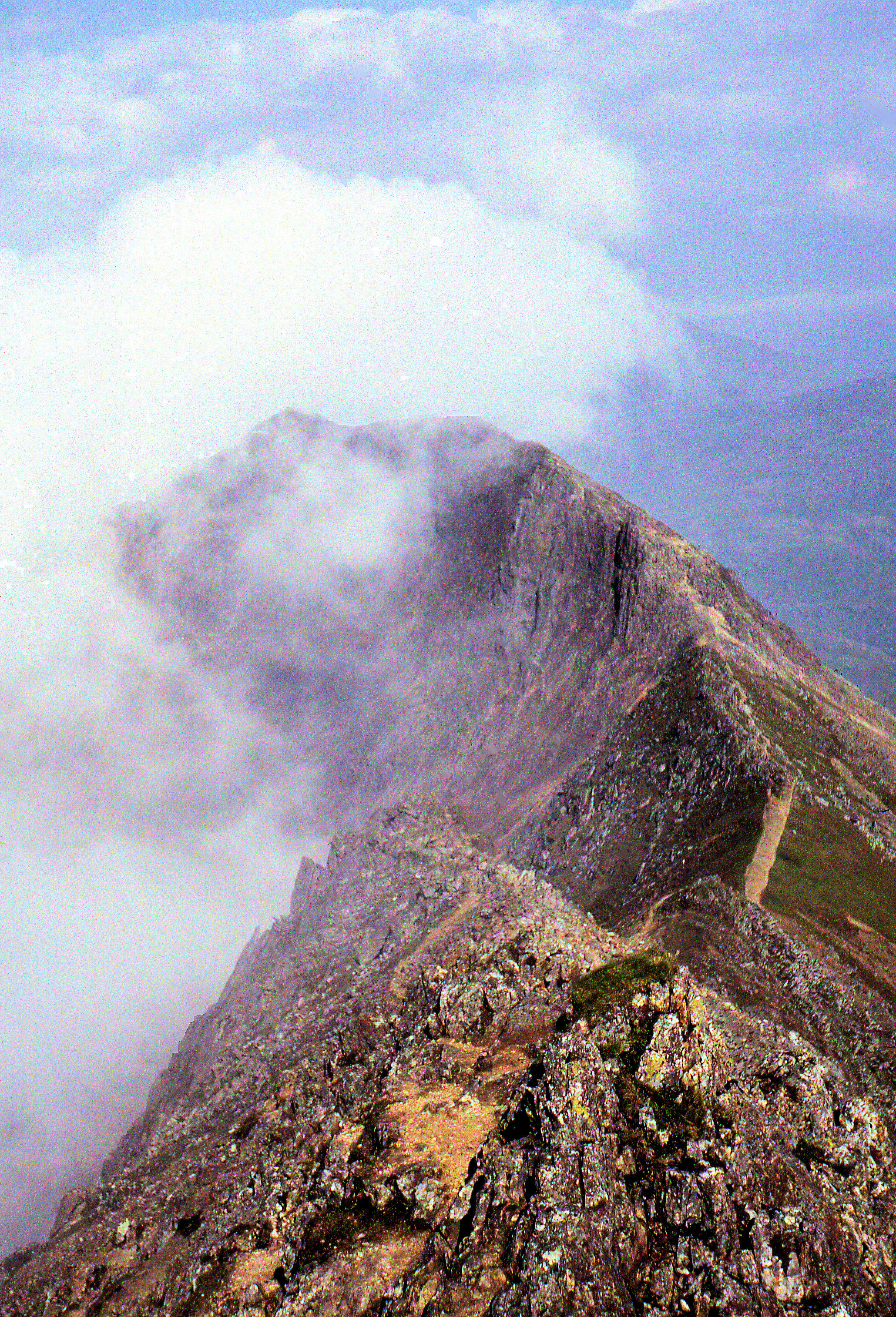
·dotted grey line: Snowdon Mountain Railway The "knife-edge" arête of Crib Goch (foreground) and the pyramidal peak of Snowdon (background) are both the result of glaciation.
The classic traverse of Crib Goch from East to West leads up from the Pyg track to a "bad step" where hands and feet are both needed briefly. It is followed by ascent to the arête, before tackling three rock-pinnacles to a grassy col at Bwlch Coch. This first part of the ridge is exposed with precipices below, having resulted in several fatalities, even of experienced mountaineers;[3][4] the Snowdonia National Park Authority describe it as "not a mountain for the inexperienced".[5] Moreover, on fine days the ridge may be very busy and queues can form. To avoid the long queues on the ascent from the east, it is possible to ascend Crib Goch's North Ridge, which adjoins the main ridge. It is recommended that walkers who use this route do have climbing skills and climbing equipment.
It is possible to ascend Crib Goch from Bwlch y Moch SH663552 or from Nant Peris, an ascent via Cwm Beudu Mawr.
From the col the ridge rises again, joining the main Snowdon ridge via the sister peak Garnedd Ugain in the west. Here the path meets the Pyg Track (which descends to Pen-y-Pass) at Bwlch Glas (marked by a large standing stone), before the final climb to Snowdon summit. To the south of the arête lie the lakes of Glaslyn and Llyn Llydaw. To the north is the Llanberis Pass. Crib Goch is classed as a Welsh 3000er and is also often climbed as the first part of the Snowdon Horseshoe, which goes on over Garnedd Ugain, Snowdon and Y Lliwedd, before returning to Pen-y-Pass.
Crib Goch is one of the wettest spots in the United Kingdom, with an average of 4,473 millimetres (176.1 in) rainfall a year over the past 30 years.[6]
See also
- W A Poucher for a description of the routes
References
- ^ Jon Doran (2002-04-17). "Snowdon Horseshoe — Best Scramble?". OUTDOORSmagic. http://www.outdoorsmagic.com/news/article/mps/UAN/1370/V/4/SP/332409698529328364490.
- ^ Steve Ashton, Scrambles in Snowdonia, (Cicerone Press, 1992)
- ^ Neal Keeling (2007-03-09). "Climber, 60, plunges 400ft to his death". Manchester Evening News. http://www.manchestereveningnews.co.uk/news/s/1001/1001503_climber_60_plunges_400ft_to_his_death.html.
- ^ "Teacher found on Snowdon". BBC News. 2003-05-12. http://news.bbc.co.uk/1/hi/wales/north_west/3019795.stm.
- ^ PYG track
- ^ Clark, Ross (2006-10-28). "The wetter, the better". The Independent. http://www.telegraph.co.uk/property/3354276/The-wetter-the-better.html. Retrieved 2009-09-02.
External links
- Climbing Crib Goch video
- Newspaper Feature: Hypnotherapy put to the test on Crib Goch. Can hypnosis really cure a fear of heights?
- On Crib Goch on YouTube
- "Police name Snowdon tragedy boy". BBC News. 2007-10-29. http://news.bbc.co.uk/1/hi/wales/north_west/7066690.stm.
- www.geograph.co.uk : photos of Crib Goch
Welsh 3000s Snowdon Massif Glyderau Carneddau Categories:- Hewitts of Wales
- Mountains and hills of Snowdonia
- Nuttalls


Wikimedia Foundation. 2010.