- New York State Route 291
-
This article is about the current alignment of NY 291. For the former alignment of NY 291 in Ontario and Seneca Counties, see New York State Route 291 (1930–1940s).
NYS Route 291
Route information Maintained by NYSDOT Length: 7.46 mi[2] (12.01 km) Existed: January 1, 1970[1] – present Major junctions South end:  NY 69 in Whitestown
North end:  NY 365 in Marcy
Location Counties: Oneida Highway system Numbered highways in New York
Interstate • U.S. • N.Y. (former) • Reference • County←  NY 290
NY 292  →
→←  NY 12B
NY 12D  →
→New York State Route 291 (NY 291) is a state highway in Oneida County, New York, in the United States. The route extends from an intersection with NY 69 in the town of Whitestown to a junction with NY 365 in the extreme northern tip of the town of Marcy, near the hamlet of Stittville. It is a two-lane highway its entire length. NY 291 meets NY 49, the Utica–Rome Expressway, at an interchange roughly 1 mile (1.6 km) northeast of NY 69. NY 291 provides access to the Marcy Correctional Facility and Mid-State Correctional Facility, both in Marcy.
The origins of NY 291 date back to 1908, when the entirety of modern NY 291 was designated as part of legislative Route 25, which began in Marcy and ended in Albany. The portion of Route 25 south of Barneveld was designated as part of New York State Route 12C, an alternate route of NY 12 between Utica and Barneveld, in 1930 renumbering of state highways in New York. The section of NY 12C south of Whitestown was entirely overlapped with other routes while the portion north of Stittville utilized what is now NY 365. On January 1, 1970, NY 12C was replaced with an extended NY 365 from Stittville to Barneveld and NY 291 from Whitestown to Stittville.
Contents
Route description
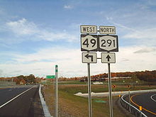 Northbound on NY 291 at the NY 49 interchange in Marcy
NY 291 begins at an intersection with NY 69 just north of the village of Whitesboro in the town of Whitestown. It travels northeast from this point, crossing over and briefly paralleling the Mohawk River as it enters the town of Marcy. Not long afterward, the route crosses over the Erie Canal and intersects River Road,[3] the pre-Utica–Rome Expressway routing of NY 49,[4] on the northern bank of the canal. Just north of River Road, NY 291 meets the aforementioned expressway at a modified diamond interchange. The route continues on to Careys Corners, a small community centered around the junction of NY 291 and Old River Road 1 mile (1.6 km) from NY 69. After another mile (1.6 km) through a lightly populated area of Marcy, NY 291 heads north toward the hamlet of Marcy at a fork with Hayes Road.[3]
In Marcy, NY 291 intersects Fox Road and provides access to the Marcy Correctional Facility and Mid-State Correctional Facility, both located just west of NY 291. Outside of Marcy, the route heads through less developed areas of the town as it heads generally northward along Ninemile Creek toward the hamlet of Stittville, a small hamlet on the eastern bank of the creek. NY 291 heads north through Stittville and crosses over Ninemile Creek, passing through another rural area before ending at a junction with NY 365 about one mile (1.6 km) southwest of the village of Holland Patent.[3]
History
In 1908, the New York State Legislature created Route 25, an unsigned legislative route that began at Whitesboro and passed through Marcy, Holland Patent and Barneveld before traversing Adirondack Park on its way to Albany. The portion of Route 25 between the western village line of Whitesboro and Careys Corners was also part of Route 28, which went from Maple View to Utica via Rome, Marcy, and Whitesboro.[5][6] Route 25 was truncated to end at Careys Corners on March 1, 1921, eliminating the overlap with Route 28.[7] When the first set of posted routes in New York were assigned in 1924, all of legislative Route 28 east of Colosse became NY 11. Also assigned at this time was NY 12, which connected Utica to Barneveld; however, it used a more direct route to the east rather than the more circuitous route via legislative Route 25.[8][9] NY 11 was renumbered to NY 76 in 1927 to eliminate the numerical duplication with the newly-designated U.S. Route 11.[10]
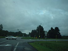 Northbound terminus of NY 291 at NY 365 north of Stittville. From 1930 to 1970, NY 12C entered from the right on NY 291 and continued into the background on NY 365 toward Barneveld.
In the 1930 renumbering of state highways in New York, NY 76 was reassigned to another highway in western New York. Its former routing between Careys Corners and Utica was incorporated into the new NY 12C, an 18.64-mile (30.00 km) alternate route of NY 12 between Utica and Barneveld that utilized the alignment of legislative Route 25 between Careys Corners and Barneveld.[2][11] NY 12C began in downtown Utica and overlapped with NY 5S to Whitesboro,[12] where it split from NY 5S and continued north to meet NY 46A near Stittville. The two routes converged here, following what is now NY 365 east to Holland Patent. NY 46A left NY 12C in the village and went north on modern NY 274 while NY 12C continued east to meet NY 12 in Barneveld.[11]
NY 12C itself never changed after 1930; however, the routes it overlapped with did. In the early 1940s, NY 5S was truncated eastward to downtown Utica and replaced with NY 69 from Rome to Utica[13][14] and NY 5A between Yorkville and Utica.[15] NY 46A, meanwhile, was renumbered to NY 274 and truncated to Holland Patent in the early 1950s.[16][17] NY 365 was assigned ca. 1932 and overlapped NY 12C between Stittville and Barneveld[18][19] until it was truncated to end at NY 12C north of Stittville in the late 1950s.[20][21] On January 1, 1970, the NY 12C designation was eliminated. From Utica to Whitesboro, NY 12C was supplanted by the routes it once overlapped; however, NY 69 was truncated to NY 5A in Yorkville. East of Stittville, NY 12C became part of a re-extended NY 365. The remainder of NY 12C's former routing was redesignated as NY 291.[1] Reference markers for NY 291 north of NY 49 still read "12C".[2]
Major intersections
The entire route is in Oneida County.
Location Mile[2] Destinations Notes Whitestown 0.00 NY 69Marcy 0.82  NY 49
NY 49Grade-separated interchange 7.46 NY 3651.000 mi = 1.609 km; 1.000 km = 0.621 mi References
- ^ a b State of New York Department of Transportation (January 1, 1970) (PDF). Official Description of Touring Routes in New York State. http://www.greaternyroads.info/pdfs/state70.pdf. Retrieved January 3, 2010.
- ^ a b c d "2008 Traffic Volume Report for New York State" (PDF). New York State Department of Transportation. June 16, 2009. pp. 13, 129, 207–208, 220. https://www.nysdot.gov/divisions/engineering/technical-services/hds-respository/NYSDOT%20TVR%202008%20by%20Route.pdf. Retrieved January 30, 2010.
- ^ a b c Yahoo! Inc. Yahoo! Maps – overview map of NY 291 (Map). Cartography by NAVTEQ. http://maps.yahoo.com/#mvt=h&lat=43.18612&lon=-75.294985&zoom=13&q1=43.1388%2C-75.305123&q2=43.233471%2C-75.287678. Retrieved May 13, 2010.
- ^ United States Geological Survey (1955). Oriskany Quadrangle – New York – Oneida Co. (Map). 1:24,000. 7.5 Minute Series (Topographic). http://www.nysgis.state.ny.us/gisdata/quads/drg24/usgspreview/index.cfm?code=o43075b3. Retrieved May 13, 2010.
- ^ State of New York Department of Highways (1909). The Highway Law. Albany, New York: J. B. Lyon Company. pp. 62, 63. http://books.google.com/books?id=jZ0AAAAAMAAJ&pg=PA62. Retrieved May 13, 2010.
- ^ New York State Department of Highways (1920). Report of the State Commissioner of Highways. Albany, New York: J. B. Lyon Company. pp. 537, 541. http://books.google.com/books?id=Sj4CAAAAYAAJ&pg=PA537. Retrieved May 13, 2010.
- ^ New York State Legislature (1921). "Tables of Laws and Codes Amended or Repealed". Laws of the State of New York passed at the One Hundred and Forty-Fourth Session of the Legislature. Albany, New York: J. B. Lyon Company. pp. 42, 62–64. http://books.google.com/books?id=6pE4AAAAIAAJ&pg=PA42. Retrieved May 13, 2010.
- ^ "New York's Main Highways Designated by Numbers". The New York Times: p. XX9. December 21, 1924.
- ^ Rand McNally and Company (1926). Rand McNally Auto Road Atlas (eastern New York) (Map). http://www.broermapsonline.org/members/NorthAmerica/UnitedStates/Midatlantic/NewYork/unitedstates1926ra_009.html. Retrieved May 13, 2010.
- ^ Automobile Blue Book. 1 (1927 ed.). Chicago: Automobile Blue Book, Inc. 1927. This edition shows U.S. Routes as they were first officially signed in 1927.
- ^ a b Automobile Legal Association (ALA) Automobile Green Book, 1930–31 and 1931–32 editions, (Scarborough Motor Guide Co., Boston, 1930 and 1931). The 1930–31 edition shows New York state routes prior to the 1930 renumbering
- ^ Thibodeau, William A. (1938). The ALA Green Book (1938–39 ed.). Automobile Legal Association.
- ^ Gulf Oil Company (1940). New York Info-Map (Map). Cartography by Rand McNally and Company.
- ^ Esso (1942). New York with Pictorial Guide (Map). Cartography by General Drafting.
- ^ State of New York Department of Public Works. Official Highway Map of New York State (Map). Cartography by General Drafting (1947–48 ed.).
- ^ Sunoco (1952). New York (Map). Cartography by Rand McNally and Company.
- ^ Esso (1954). New York with Special Maps of Putnam–Rockland–Westchester Counties and Finger Lakes Region (Map). Cartography by General Drafting (1955–56 ed.).
- ^ Kendall Refining Company (1931). New York (Map). Cartography by H.M. Gousha Company.
- ^ Texas Oil Company (1932). Texaco Road Map – New York (Map). Cartography by Rand McNally and Company.
- ^ Esso (1958). New York with Special Maps of Putnam–Rockland–Westchester Counties and Finger Lakes Region (Map). Cartography by General Drafting (1958 ed.).
- ^ Gulf (1960). New York and New Jersey Tourgide Map (Map). Cartography by Rand McNally and Company.
External links
Categories:- State highways in New York
- Transportation in Oneida County, New York


Wikimedia Foundation. 2010.