- Ellef Ringnes Island
Infobox Islands
name = Ellef Ringnes Island
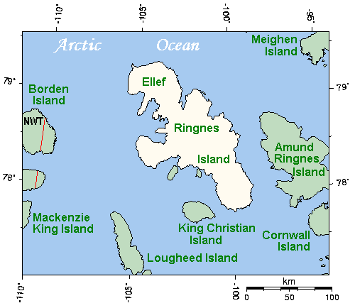
image caption = Closeup of Ellef Ringnes Island and neighbouring islands
image size =
locator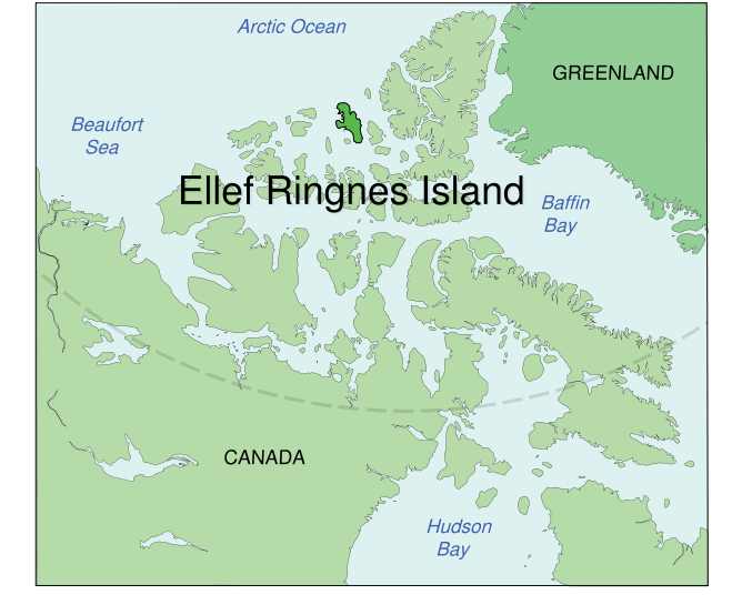
map_custom = no
native name =
native name link = Inuktikut
nickname =
location =Northern Canada
coordinates = coord|78|37|N|101|56|W|display=inline,title
archipelago =Sverdrup Islands Canadian Arctic Archipelago
total islands =
major islands =
area = convert|11295|km2|sqmi|abbr=on
rank = 69th
highest mount = unnamed
elevation = convert|260|m|ft|abbr=on
country = Canada
country admin divisions title = Territory
country admin divisions = flag|Nunavut
country admin divisions title 1 =Qikiqtaaluk Region
country admin divisions 1 =
country admin divisions title 2 =
country admin divisions 2 =
country capital city =
country largest city =
country largest city population =
country leader title =
country leader name =
population = Uninhabited
population as of =
density =
ethnic groups =
additional info =Ellef Ringnes Island is one of the
Sverdrup Islands inNunavut ,Canada . A member of theCanadian Arctic Archipelago , it lies east ofBorden Island , west ofAmund Ringnes Island and has an area of 4,361 square miles (11 295 km²), making it the 69th largest island in the world and Canada's 16th largest island. The weather monitoring station of Isachsen lies on the west coast of the island. The island's position is 78°36′46"N, 101°56′13"W. Its highest elevation is 260 m.The island was named by
Otto Sverdrup for Oslo brewer Ellef Ringnes, one of the sponsors of his expedition. The island was then claimed byNorway from 1902 until the claim was relinquished (in favour of Canada) in 1930.Ellef Ringnes Island was the last landmass to be visited by the Earth's wandering
Magnetic North Pole . In April and May of 1994, Larry Newitt, of theGeological Survey of Canada , and Charles Barton, of theAustralian Geological Survey Organisation , conducted a survey to determine the average position of the North Magnetic Pole at that time. They established a temporary magnetic observatory onLougheed Island , close to the predicted position of the pole. They determined that the average position of the North Magnetic Pole in 1994 was located on the Noice Peninsula, southwest Ellef Ringnes Island, at 78.3° N, 104.0° W. The pole shifted from the island that year and now lies some 250 miles (400 km) to the NNW [http://gsc.nrcan.gc.ca/geomag/nmp/northpole_e.php] .Further reading
* Antoniades, Dermot, Marianne S V Douglas, and John P Smol. 2003. "The Physical and Chemical Limnology of 24 Ponds and One Lake from Isachsen, Ellef Ringnes Island, Canadian High Arctic". "International Review of Hydrobiology". 88, no. 5: 519.
* Atkinson, Nigel. 2003. "Late Wisconsinan Glaciation of Amund and Ellef Ringnes Islands, Nunavut: Evidence for the Configuration, Dynamics, and Deglacial Chronology of the Northwest Sector of the Innuitian Ice Sheet". "Canadian Journal of Earth Sciences". 40: 351-363.
* Lea, Brian N. "Oceanographic Observations Near Cape Macmillan, Ellef Ringnes Island, N.W.T". Victoria: Dobrocky Seatech Limited, 1978.
* Saville, D. B. O. "Bird and Mammal Observations on Ellef Ringnes Island in 1960". 1961.
* Stott, Donald F. "Ellef Ringnes Island, Canadian Arctic Archipelago". [Ottawa] : Dept. of Energy, Mines and Resources, 1969.

Wikimedia Foundation. 2010.