- Mullach nan Coirean
-
Mullach nan Coirean 
Mullach nan Coirean seen from Stob Bàn across Coire Dearg.Elevation 939 m (3,081 ft) Prominence 93 m (305 ft) Parent peak Stob Bàn Listing Munro Translation Summit of the Corries (Scottish Gaelic) Pronunciation Scottish Gaelic: [ˈmulˠ̪əx nəŋ ˈkʰɔɾʲən]
English approx: moo-luhkh nuhn kor-yuhnLocation Location Highland,  Scotland
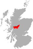
Range Mamores Coordinates 56°45′00″N 5°04′21″W / 56.7499°N 5.0724°WCoordinates: 56°45′00″N 5°04′21″W / 56.7499°N 5.0724°W Topo map OS Landranger 41, OS Explorers 392 OS grid NN122662 Listed summits of Mullach nan Coirean Name Grid ref Height Status Stob Coire Dearg NN131654 917 m (3008 ft) Munro Top Mullach nan Coirean is a Scottish mountain situated in the Mamores group of hills. It reaches a height of 939 metres (3081 feet) and is located eight kilometres north-west of Kinlochleven. It is the most westerly of the ten Munros in the Mamores and it is connected to the adjoining mountain of Stob Bàn by a col with a height of 846 metres; these two Munros are often climbed together from Glen Nevis[1]. The mountain's name translates from the Gaelic as "Summit of the Corries"[2] or Top of the Corries[3] and this is quite fitting as Mullach nan Coirean has four corries on its slopes. Mullach can also mean a "roof" [1]. However it is unusual that the name does not include reference to the mountains distinct red tinge cause by its red granite rock.
Mullach nan Coirean stands in stark contrast to the adjoining Stob Bàn, which is a pointed and light coloured peak, owing to its crown of quartzite. Mullach nan Coirean differs, being a large sprawling mountain of ridges and corries with its granite rock giving the mountain a definite red shade (see picture). The mountain has three north facing corries: the finest of these is Coire Dearg (Red Corrie) which is drained by the Allt a' Choire Dheirg into Glen Nevis and is overlooked by Mullach nan Coirean’s South East Top (917 metres) which is listed as a "top" in the Munro Tables[4]. The South East Top was previously called "Coire Dearg Top" but was changed to avoid confusion as the main summit also overlooks Coire Dearg. The other two northern corries are smaller: Coire Riabhach also drains to Glen Nevis while Coire a’ Mhuillinn empties further west into the River Kiachnish which delineates the mountain's western boundary. A fourth corrie, Coire Carach stands on the mountain's southern slopes.
Mullach nan Coirean has four ridges radiating from its summit. The eastern ridge links to the adjoining Munro of Stob Bàn which is three kilometres away, whilst the south western ridge links to the subsidiary top of Meall a' Chaorainn (910 metres) before descending steeply to the valley of the River Kiachnish. The northern ridge is four kilometres long and has the vitrified fort of Dùn Deardail ("Fort of the Red Eye")[5] near its terminus just before it joins Glen Nevis. The fort is probably named after Deirdre, the princess of Ulster, it is one in a line of vitrified forts that stretches from Craig Phàdraig outside Inverness to the west coast[6]. The north east ridge also descends to Glen Nevis but is much shorter. The mountain's lower northern slopes are covered by the coniferous woodland of the Nevis Forest.
As already mentioned, Mullach nan Coirean is often ascended in conjunction with the neighbouring Stob Bàn; this walk starts at Achriabhach and climbs Coire a' Mhusgain before crossing Stob Bàn to reach Mullach nan Coirean. A direct ascent of the mountain starts at the same place and goes through the Nevis Forest to reach Mullach nan Coirean’s north east ridge which is ascended to the summit. The top of the mountain is an excellent place to view Loch Linnhe[7].
References
- The Munros: Donald Bennett et al.: Scottish Mountaineering Trust: ISBN 0-907521-13-4
- 100 Best Routes on Scottish Mountains, Ralph Storer, ISBN 0-7515-0300-2
- Hamish’s Mountain Walk, Hamish Brown, ISBN 1-898573-08-5
Footnotes
- ^ Munro Magic. Gives basic combined walk details from Achriabhach.
- ^ "The Munros" Page 69 (Gives Gaelic translation as "Summit of the Corries") .
- ^ "The High Mounains of Britain and Ireland" Pages 88 (Gives Gaelic translation as "Top of the Corries").
- ^ Online version of Munro Tables. Gives details of South Top as a "Top".
- ^ "Hamish's Mountain Walk" Page 166 (Gives info on Dùn Deardail vitrified fort).
- ^ The Modern Antiquarian. Gives further details of fort.
- ^ "The Munros" Page 69 ("... fine view down Loch Linnhe").
Nevis range 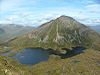
Mamores Am Bodach · An Gearanach · Binnein Beag · Binnein Mòr · Na Gruagaichean · Sgurr Eilde Mòr · Sgurr a' Mhàim · Stob Bàn · Stob Coire a' Chàirn · Mullach nan CoireanGrey Corries Alder/Ardverikie Aonach Beag · Ben Alder · Beinn Bheòil · Beinn a' Chlachair · Beinn Eibhinn · Càrn Dearg · Creag Pitridh · Geal-Chàrn · Mullach Coire an IubhairOssian/Treig Beinn na Lap · Càrn Dearg · Chno Dearg · Stob a' Choire Mheadhoin · Stob Coire Easain · Stob Coire Sgriodain · Stob GaibhreList of Munros Categories:- Munros
- Mountains and hills of the Central Highlands


Wikimedia Foundation. 2010.