- U.S. Route 101
Infobox U.S. Route
route=101
marker_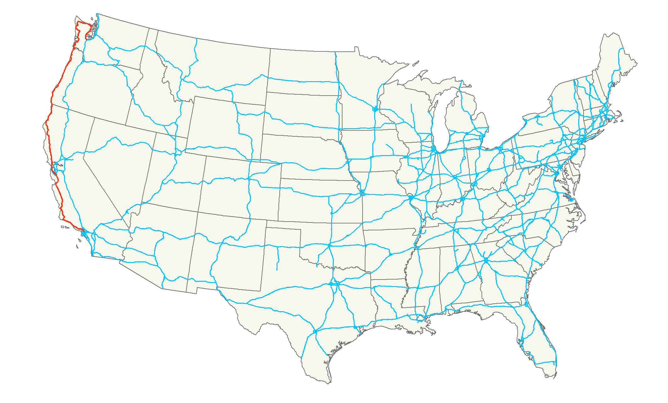
length_mi=1540
length_round=0
length_ref= [http://www.us-highways.com/us1830.htm US Highways from US 1 to US 830] Robert V. Droz]
formed=1926
direction_a=South
terminus_a=Jct|state=CA|I|5|SR|60 in Los Angeles, CA
junction=Jct|state=CA|I|405 in Sherman Oaks, CA
Jct|state=CA|I|880 in San Jose, CA
Jct|state=CA|I|80 in San Francisco, CA
Jct|state=CA|I|580 in San Rafael, CA
Jct|state=OR|US|20 in Newport, OR
Jct|state=OR|US|30 in Astoria, OR
Jct|state=WA|US|12 in Aberdeen, WA
direction_b=North
terminus_b=Jct|state=WA|I|5 in Olympia, WAU.S. Route 101, or U.S. Highway 101, is a
U.S. highway running north-south through the states of California, Oregon, and Washington, on the farWest Coast of the United States . It is also known asEl Camino Real "(The Royal Road)" where its route along the southern and central California coast approximates the old trail which linked the Spanish missions, pueblos and presidios. It merges at some points with California Route 1.According to the AASHTO's numbering scheme for U.S. Highways, three-digit route numbers are generally subsidiaries of two-digit routes. However, the principal north-south routes were assigned numbers ending in 1. Rather than lose four available north-south numbers (93, 95, 97, and 99) or assign the primary west coast highway a "lesser" number, the AASHTO made an exception to its two-digit rule. Thus, U.S. 101 is treated as a primary, two-digit route with a "first digit" of 10, rather than a spur of U.S. 1. Thus U.S. Route 101, not U.S. 99, is the westernmost north-south route in the U.S. Highway system.
U.S. Route 101 was once the major north-south link along the Pacific coast. North of San Francisco, it has been replaced in importance by the highways of the
Interstate Highway System, specificallyInterstate 5 , which is more modern in its physical design. Route 101 is still in use as a parallel freeway or highway between Los Angeles and San Francisco, and is an alternative to the Interstate for most of its length. In 1964, California truncated its southern terminus in Los Angeles, as Interstate 5 replaced it. The old road is known as county road S-21 or Historic Route 101 in northern San Diego County.The highway's "northern" terminus is in Olympia,
Washington , though the northernmost point on the highway is in Port Angeles. The southern terminus of U.S. 101 is in Los Angeles,California at theEast Los Angeles Interchange , the world's busiest freeway interchange. [ [http://www.scvresources.com/highways/east_los_angeles_interchange.htm East Los Angeles Interchange ] ]Route description
U.S. Route 101 may be called the "Oregon Coast Highway" in
Oregon , and the "Pacific Highway" in parts ofCalifornia . It is also called "The 101" by residents ofSouthern California or simply "101" by residents ofNorthern California ,Oregon , andWashington . From north of San Francisco and continuing to Oregon it is also referred to as the "Redwood Highway ". Urban portions of the route in Southern California are named theSanta Ana Freeway ,Hollywood Freeway , andVentura Freeway at various points betweenEast Los Angeles andCarpinteria, California [ [http://www.dot.ca.gov/hq/tsip/hseb/products/Named_Freeways.pdf 2007 Named Freeways, Highways, Structures and Other Appurtenances In California] ] . Urban portions of the route in the Bay Area are called the James Lick Freeway,Bayshore Freeway , andCentral Freeway . A portion of the route north ofSalinas, California is named Sig Sanchez Highway. Street routings in San Francisco are more commonly referred to by their street names rather than the route number. Portions of the route between Southern California and the Bay Area are named El Camino Real or El Camino Real Freeway, but such names are rarely used colloquially in lieu of the route number.California
In Southern California, the highway is a heavily traveled
commuter route serving the Northwest portion of theGreater Los Angeles area; this includesVentura County communities in the WestConejo Valley and in theOxnard Plain , along withLos Angeles County communities in the EastConejo Valley andSan Fernando Valley . The route is the Santa Ana Freeway from East Los Angeles toDowntown Los Angeles . It becomes the Hollywood Freeway north from Downtown Los Angeles through theCahuenga Pass , before turning west and becoming the Ventura Freeway. Communities along the alignment includeHollywood and the southern edge of theSan Fernando Valley , and the cities of Hidden Hills, Calabasas, Agoura Hills, Westlake Village, Thousand Oaks (includes Newbury Park), Camarillo, Oxnard, Ventura, and Santa Barbara. US 101 also integrates with the southern part of the historic El Camino Real.before reaching the Oregon State Line.
Unlike Washington, California does not sign the long east-west section of U.S. 101 between
Point Conception and its junction with California State Route 134 and 170 in North Hollywood as "West" and "East." Instead, Caltrans observes the overall direction of the highway and marks these portions as "North" and "South". Local references to this potion of the freeway, including traffic reports, refer to the directions on this section as east for southbound lanes and west for northbound lanes. In the late 90s, Caltrans began placing guide signs on local streets in theSan Fernando Valley adjacent to the 101 which identified eastbound and westbound entrances to the freeway. Other than replacing older guide signs which previously referenced the official northbound and southbound designations of the freeway, Caltrans made no other changes to mainline or street signing, and as such, pull-through signs, overhead signs, and freeway entrance signs all still reference north and south instead of east and west.Oregon
U.S. Route 101 enters Oregon four miles (6 km) south of Brookings, and is seldom out of sight of the Pacific Ocean except the northern end near Astoria; the major exception being a significant inland stretch south of
Tillamook, Oregon . It crosses the Siuslaw River Bridge in Florence. The stretch between Florence and Yachats is considered one of the more attractive segments of this highway. There are a number of Oregonstate park s along the Pacific coast, including theHeceta Head Lighthouse . Because U.S. 101 forms the main street of almost all of the coastal towns in Oregon (with the exception of Cannon Beach and a few others), it is frequently, though not always, congested and slow. The highway crosses the mouth of theColumbia River over the 4-mile-long (6-km)Astoria-Megler Bridge at Astoria intoWashington , and follows the Columbia downstream to Ilwaco.Washington
From Ilwaco, U.S. 101 follows the Pacific coastline as far as Raymond, from which it proceeds directly north to Aberdeen, offering access from this city into the
Olympic National Park . While the AAA has designated this segment north and then east to Port Angeles and Sequim as a scenic byway, some clear-cutlogging in the early 1990s has diminished the scenic value of the highway where it crosses the Quinault Indian Reservation and theOlympic National Forest . An expressway goes through Sequim. East of Sequim, Route 101 turns southward, leading to Shelton and its "northern" terminus in Olympia, the state capital. Upon reaching Shelton, U.S. 101 turns into a two lane bypass that changes to a freeway at the junction of State Route 3, merging with State Route 8 and finally ending atInterstate 5 .The highway runs north through Washington, running parallel to the Pacific Coast, all the way up the western side of the
Olympic Peninsula . In the northwestern part of the peninsula, the highway turns east, and runs along the peninsula's northern edge, parallel to theStrait of Juan de Fuca . In the peninsula's northeast corner, the highway then turns south, running along the eastern edge of the peninsula and along the western shore ofHood Canal , until the highway terminates at a junction withInterstate 5 in Olympia. Between the intersection with State Route 112, on the western edge of theOlympic Mountains , U.S. 101 is signed east/west, and roughly south of the intersection with State Route 20, U.S. 101 is signed north/ south but having turned around 180 degrees. The direct route between the towns of Aberdeen (on the coast) and Olympia is US 12 and State Route 8.The Washington section of U.S. 101 is defined at Washington Revised Code §47.17.165. [ [http://apps.leg.wa.gov/RCW/default.aspx?cite=47.17.165 RCW 47.17.165: State route No. 101 ] ]
History
Parts of Historic Route 101 can still be found in San Diego County between Oceanside and the border with
Mexico under a variety of different names. Through Oceanside it is called Coast Highway. In Carlsbad it becomes Carlsbad Blvd, but to the south in Encinitas it is Coast Highway 101. Solana Beach keeps it consistent with Highway 101, but Del Mar changes it to Camino Del Mar. All of those together make upSan Diego County Route S21 . From there it continues along Torrey Pines Road toInterstate 5 in La Jolla. The old 101 routing continues on I-5 inSan Diego until Pacific Highway, the old U.S. 101 freeway a little west of current I-5. It then continued on Harbor Drive and Broadway through Downtown San Diego and Chula Vista, then onto National City Blvd in National City. The southern parts of I-5 were U.S. 101 for a period before I-5 was completed also. All have been decommissioned, but the roadways still exist and are occasionally signed as Historic 101.Most of Historic 101 between Gilroy and San Francisco is still active, either signed as Business 101 or as State Route 82. The 101A bypass, however, is mostly discontinuous and is paralleled by the actual freeway, in some cases serving as an access road to the freeway.
Large parts of the old U.S. Business 101 and State Route 82 surface roads between San Francisco and San Diego are designated El Camino Real (The Royal Road), a designation originally given any thoroughfare under the direct authority of the King of Spain and his viceroys. These portions constitute the first major road in California.
Before the
Golden Gate Bridge was completed, Highway 101 was divided in the San Francisco Bay Area. 101-W (west) followed the same general right-of-way of today's 101 from San Jose to San Francisco. 101-E (east) generally followed the right-of-way taken by today's I-880 from San Jose to Oakland. Since there was no Golden Gate Bridge yet, 101-W became a ferry ride across the Golden Gate Strait. As today, 101-W proceeded up Van Ness, but without any left turn at Lombard, ending at theHyde Street Pier . From there, motorists would drive onto a ferry boat which would cross the Golden Gate toSausalito , where they would drive off the ferry directly onto the main street of Sausalito, which was signed for U.S. 101 once again. [http://webbie1.sfpl.org/multimedia/sfphotos/AAC-2256.jpg]The 101-E designation was removed by the 1940s and became state Route 17 (later Interstates 880 and 580) between San Jose and Santa Rosa. As the Bayshore Freeway was built along the east side of the San Francisco peninsula in the early 1950s, old U.S. 101 along the El Camino Real was posted as U.S. 101 Alternate or 101-a, and the freeway was marked U.S. 101-Bypass or 101-B. In 1964, when California renumbering numerous state highways, El Camino was renumbered California 82 and the Bayshore Freeway lost the Bypass designation.
ee also
*
Bannered routes of U.S. Route 101
*BC Highway 101, a Canadian "extension" of the highway.References
External links
* [http://www.us-101.com/ US-101 Info,Maps,and More!]
* [http://www.historic101.com Historic101.com]
* [http://www.gbcnet.com/ushighways/US101/US101.html Historic California US Highways]
* [http://www.scvresources.com/highways/east_los_angeles_interchange.htm East Los Angeles Interchange Complex]
* [http://www.geocities.com/usend0009/End101/end101.htm Endpoints of US highways]
Wikimedia Foundation. 2010.