- U.S. Route 35
-
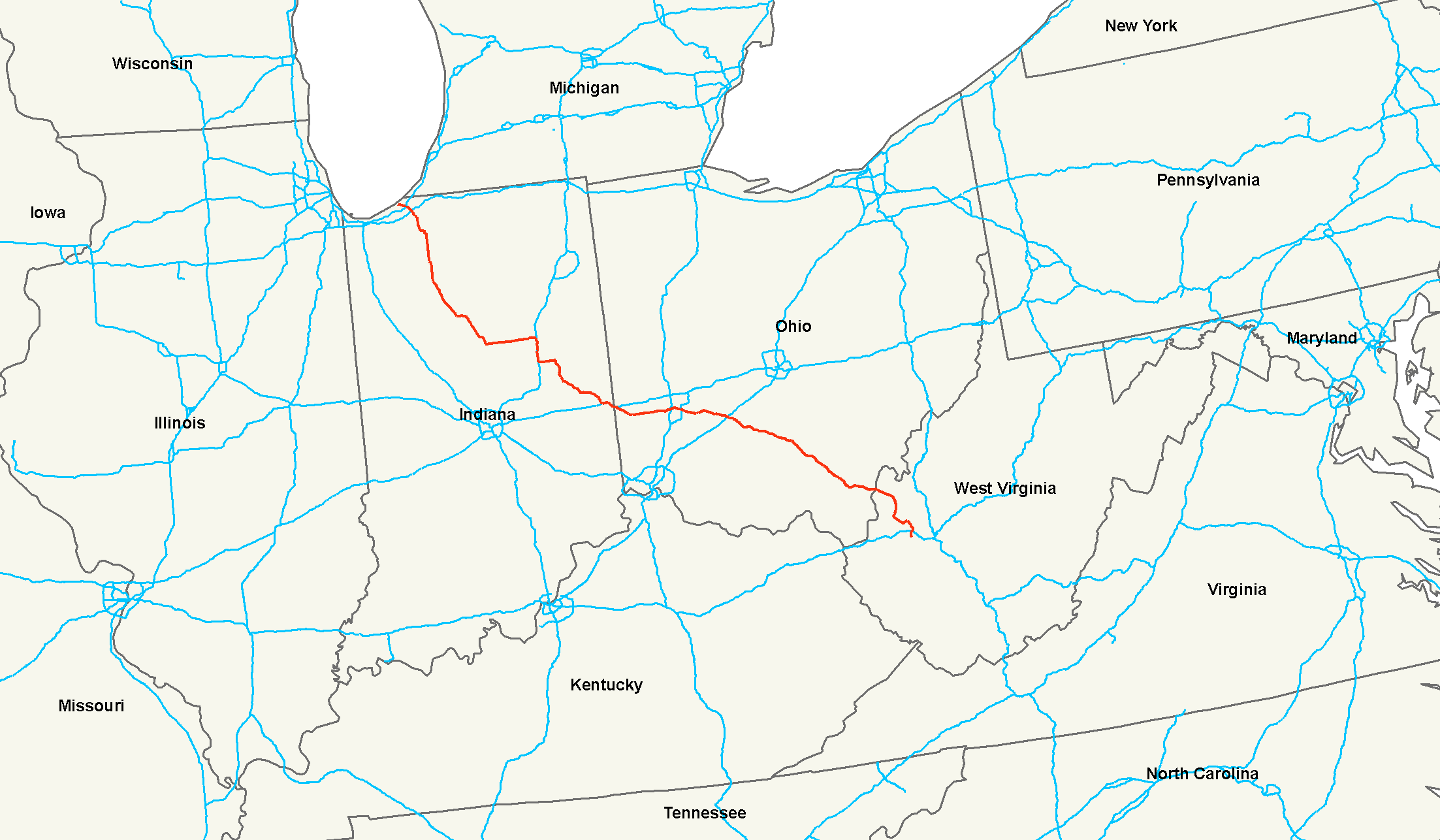
U.S. Route 35

Route information Length: 412 mi[1] (663 km) Existed: 1934[1] – present Major junctions South end:  I-64 at Scott Depot, WV
 WV 2 at Point Pleasant, WV
 SR 7 at Gallipolis, OH

 US 23 / US 50 at Chillicothe, OH
 I-71 at Jeffersonville, OH
 I-675 at Beavercreek, OH
 I-75 at Dayton, OH
 I-70 in Richmond, IN
 US 30 near Hamlet, IN
North end:  US 20 at Michigan City, IN
Highway system United States Numbered Highways
List • Bannered • Divided • ReplacedU.S. Route 35 is a north–south United States highway that runs northwest-southeast for approximately 412 miles (663 km) from northern Indiana to the western suburbs of Charleston, West Virginia. The highway's northern terminus is in Michigan City, Indiana, at U.S. Route 20. Its southern terminus is in Scott Depot, West Virginia, at Interstate 64.[2] Currently, the West Virginia portion of the highway is being expanded to four lanes, mostly along a completely new route. The Ohio portion has already been upgraded to a four-lane highway/freeway between the West Virginia state line and Trotwood west of Dayton, Ohio.
Contents
Route description
West Virginia
In West Virginia from Scott Depot to Point Pleasant, US 35 is currently being expanded to a four-lane expressway. Currently the route is four lanes from I-64 to the junction with the bridge to Buffalo, (West Virginia Route 869), which serves the large Toyota engine and transmission plant in Buffalo, and continues as a 2-lane route for 12 miles (19 km) to another four lane section of eight miles (6 km) to the Ohio River, which is the state line.
The remaining 12 mile gap is currently "unfunded". A possibility of completion as a toll road has been put forward.
Officially, US 35's new alignment begins at I-64 Exit #40 near Scott Depot, from which point US 35 proceeds north on its new roadway.[2] As of June 15, 2009, the old segment of US 35 between Buffalo Bridge and U.S. Route 60 is now signed WV 817.
Ohio
Signed east–west in Ohio, US 35 crosses the Ohio River on the Silver Memorial Bridge and enters Ohio. The first interchange is located adjacent to the Gallia-Meigs Regional Airport in Gallipolis as well as State Route 7. From there, it continues as a full freeway towards Jackson, with interchanges at SR 160, SR 850, and SR 325. Passing Rio Grande, the highway becomes a four lane at-grade expressway when it reaches Centerville. This setup continues until State Route 32 where the highway bypasses Jackson. A strange interchange configuration currently exists at US 35 and OH 32 - an interchange called a Windmill interchange. Each highway has ramps that exit to the other highway ending at an intersection that one can travel either direction — odd because both highways end up having at-grade intersections. Continuing west, the highway reverts to an expressway until it reaches Richmond Dale. The section between Richmond Dale and Chillicothe was upgraded to a full freeway in 2005 and includes a large cut through a 1,000 feet (300 m) ridge. This section of road provides westbound motorists with a panoramic view of the Scioto River valley. Travelers eastbound at Chillicothe near the Bridge Street exit can see the hills that are shown on the Great Seal of the State of Ohio. The next major interchange is with I-71 in Jeffersonville. As the route continues through flat farmlands, it creates a full-access interchange with I-675 in Beavercreek. Several miles later, US 35 opens into a three through lane highway (with five lanes in some parts) through downtown Dayton and makes another full-access interchange with I-75 in downtown Dayton. The Ohio portion of US 35 merges with I-70 near New Paris. The portion of US 35 from the western edge of Dayton to the merge with I-70 is the only 2 lane section remaining, passing through the city of Eaton. US 35 is a major Appalachian corridor linking I-70 and points west to I-64 and points east.
The portion of the route between Jackson and Gallipolis is known as the Bob Evans Highway. This section is designated as a Welsh Byway by the Ohio Department of Transportation as well.[3]
Indiana
US 35 enters Indiana with Interstate 70, and splits off on the northwest side of Richmond. US 35 then travels in a northwest path through the cities of Muncie, Kokomo, Logansport, Winamac, Knox and La Porte before terminating at US 20 in Michigan City.
On October 1, 2009, the State transferred the western 5.31 miles (8.55 km) of US 35 to Michigan City's local highway system. US 35 in Michigan City is currently being served by commercial traffic that travels in and out of downtown (where it originally terminated at US 12); according to local traffic counts, only half of measured traffic on US 35 is through traffic. After the transfer of control, Michigan City began reconstructing the road using local, state and federal-aid funds.[4] The change was approved by AASHTO on October 17, 2008.[5]
Major intersections
West Virginia
County Location Mile Destinations Notes Putnam Scott Depot 0 I-64 – Huntington, CharlestonInterchange at I-64 Exit 40  CR 33 (Teays Valley Rd) – Scott Depot
Access via connector continuing along same alignment as new US 35. Teays Valley 2 
 WV 34 / CR 13 (Poplar Fork Road) – Teays Valley
Fraziers Bottom 10  CR 19 (Five and Twentymile Creek Road) – Hurricane
8.5 
 WV 869 to WV 62 – Buffalo
Pliny  CR 9 (Plantation Rd) – Apple Grove
Mason Pt. Pleasant  CR 35 north (Locks Road) WV 2 – Point Pleasant, Huntington
Last exit in West Virginia before entering Ohio References
- ^ a b Droz, Robert V. U.S. Highways : From US 1 to (US 830). URL accessed 02:55, 4 July 2006 (UTC).
- ^ a b "West Virginia US 35 Deletion Request". American Association of State Highway and Transportation Officials. http://cms.transportation.org/sites/route/docs/AR-M550U_20080827_114716.pdf. Retrieved 2008-10-11.
- ^ Ohio Department of Transportation. "Ohio Byway". http://www.ohiobyways.com/. Retrieved 2007-07-18.
- ^ Indiana Department of Transportation (2008-08-25). "An Application from the State highway or Transportation Department of Indiana". http://www.transportation.org/sites/route/docs/Indiana%20-%20US%2035.pdf. Retrieved 2008-10-27.
- ^ AASHTO (2008-10-27). "Committee action and approvals". http://www.transportation.org/?siteid=68&pageid=1540. Retrieved 2008-10-27.
External links
 Main U.S. Routes
1 2 3 4 5 6 7 8 9 10 11 12 13 14 15 16 17 18 19 20 21 22 23 24 25 26 27 28 29 30 31 32 33 34 35 36 37 38 40 41 42 43 44 45 46 48 49 50 51 52 53 54 55 56 57 58 59 60 61 62 63 64 65 66 67 68 69 70 71 72 73 74 75 76 77 78 79 80 81 82 83 84 85 87 89 90 91 92 93 94 95 96 97 98 99 101 163 400 412 425 Lists U.S. Routes • Bannered • Divided • Bypassed Categories:- U.S. Highway System
- U.S. Highways in West Virginia
- U.S. Highways in Indiana
- U.S. Highways in Ohio
- Transportation in Mason County, West Virginia
- Transportation in Putnam County, West Virginia
- Transportation in Dayton, Ohio
- Transportation in Preble County, Ohio
- Transportation in Gallia County, Ohio
- Transportation in Greene County, Ohio
- Transportation in Montgomery County, Ohio

Wikimedia Foundation. 2010.