- U.S. Route 42
-
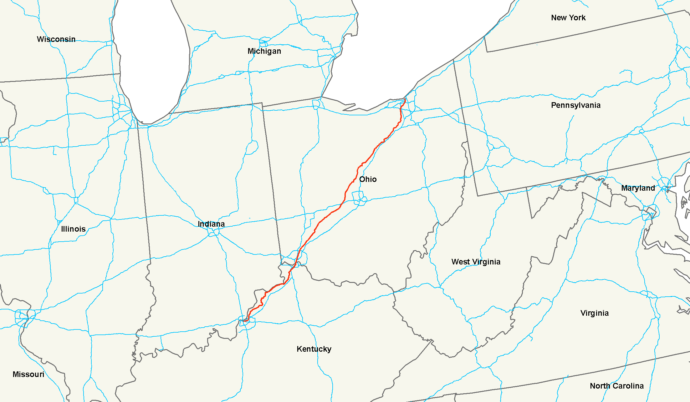
U.S. Route 42

Route information Length: 355 mi[1] (571 km) Existed: 1926[1] – present Major junctions West end: 
 US 31E / US 60 at Louisville, KY
 I-71 / I-75 at Cincinnati, OH
 I-70 near Lafayette, OH
 I-80 near Cleveland, OH
East end: 
 US 6 / US 20 at Cleveland, OH
Highway system United States Numbered Highways
List • Bannered • Divided • ReplacedU.S. Route 42 is an east–west United States highway that runs northeast-southwest for 355 miles (571 km) from Cleveland, Ohio to Louisville, Kentucky. The route has several names including Pearl Road from Cleveland to Medina in Northeast Ohio, the Cincinnati and Lebanon Pike in southwestern Ohio and Brownsboro Road in Louisville, Kentucky. The highway's eastern terminus is in Downtown Cleveland, Ohio. Its western terminus is in Louisville, Kentucky.
I-71 fully supplanted US 42 as an interurban highway in the early 1960s, relegating US 42 to its current role as if an ordinary town-to-town surface road. Unlike I-71, US 42 avoided Columbus completely. It remains intact as a route; no part of it has ever been diverted to any Interstate highway. It is not the "parent" of any US route with a related number.
Contents
Route description
Kentucky
U.S. 42 crosses into Covington, Kentucky on the Clay Wade Bailey Bridge, joined with U.S. 25 and 127. Once in Covington, U.S. 42 crosses KY 8 and heads south as Main Street. Main Street dead-ends into Pike Street, sending U.S. 25-42-127 off to the right. The road crosses Interstate 71/Interstate 75, and then winds its way out of Covington and into the suburbs, with its name changing from Pike Street to Dixie Highway. Heading in a southwest direction closely parallel to I-71/I-75, U.S. 42 starts off mostly as a commercial road, turning more and more into a residential road as it heads further south. Covington Catholic High School lies along this portion of U.S. 42. After crossing I-71/I-75 again, U.S. 42 becomes almost purely a residential road, with a few exceptions here and there. Continuing south, the route is joined with KY 371 for about 500 feet (150 m). Two intersections later is the KY 1303 (Turkeyfoot Road) northern terminus. U.S. 42 then crosses under Interstate 275 and proceeds to turn back into a commercial road. The Crestview Hills Town Center lies just south of I-275 on the east side of the road, in between Dixie Highway and Turkeyfoot Road. Dixie Heights High School sits less than a mile down the road, on the western side. After crossing into Erlanger, U.S. 42 becomes narrower and more congested once it crosses KY 236. U.S. 42 becomes almost entirely a commercial road for the duration of its length in Erlanger. After crossing briefly into Elsmere, U.S. 42 crosses into Boone County and the city of Florence. A couple of miles into Florence, U.S. 25 splits off from U.S. 42 and heads south, carrying the name "Dixie Highway" with it. U.S. 42 continues southwest with U.S. 127. After a couple of miles, it crosses I-71/I-75 again. While I-71/I-75 has turned back to north/south at this point, U.S. 42 and U.S. 127 continue to point southwest/northeast. Kentucky Routes 842 and 237 intersect with U.S. 42 in the next couple miles, before the road leaves Florence and enters Union. After entering Union, U.S. 42 also turns south, intersecting with KY 536 (Mount Zion Road). Continuing south, Ryle High School sits on the road's west side. Just south of Ryle, U.S. 42 turns from a five-lane road to a two-lane country road. Several miles further south, U.S. 42 meets up with KY 338 (Richwood Pike), creating a wrong-way concurrency between U.S. 127 and KY 338: when going south, you are traveling west on U.S. 42, south on U.S. 127 and north on KY 338. This lasts for less than a mile, until the intersection with Beaver Road. KY 338 follows Beaver Road to the west, as U.S. 42 and U.S. 127 continue south. About four miles (6 km) south is KY 14's western terminus. U.S. 42 and U.S. 127 continue running southwest, reaching the Boone/Gallatin County line about 2.25 miles (3.62 km) southwest of KY 14. The two joined routes continue moving southwest, inching closer and closer to the Ohio River. Finally, about five miles (8 km) west of Warsaw and right on the bank of the Ohio River, U.S. 127 separates from U.S. 42. U.S. 127 heads south toward Glencoe, Owenton and eventually Frankfort. U.S. 42 continues to run parallel to the Ohio River, crossing through Carrollton where it crosses the Kentucky River, U.S. 42 continues through Henry County into Oldham County where it passes through Goshen and North Oldham High School which sits off to its north side, through Prospect, on the Oldham and Jefferson County line as it heads in a southwest direction toward Louisville.
Ohio
The eastern/northern end of U.S. 42 finds its terminus at the intersection of Superior Ave. and Ontario St. in the middle of Public Square in Downtown Cleveland. This intersection also serves as the western terminus of US 322 coming from the east on Superior as well as the western termini of US 422, OH 14, and OH 87 and the northern terminus of OH 8 coming from the south on Ontario.
At this point on the route the road is very much a business district surrounded by varying business and residents of the Ohio City neighborhood. Along this stretch of the route you can find many historic buildings including the West Side Market. It essentially stays a business/residential area as it continues south along W. 25th. Also in this stretch the route is designated as part of the Canalway Ohio Scenic Byway. U.S. 42 continues south with nearby entrances to Interstate 90 Westbound and then a junction with Interstate 71 (U.S. 42 junctions I-71 again in Middleburg Heights, Ohio further south and west). It is at this point that the route becomes known locally as Pearl Road and begins a more south-west course. It travels out of Cleveland, Ohio into Brooklyn, Ohio; Parma, Ohio; Parma Heights, Ohio; Middleburg Heights, Ohio; and Strongsville, Ohio in Cuyahoga County, Ohio. At Mansfield, Ohio, the road is signed U.S. Route 42 north and south, rare for an even-numbered U.S. highway.
See also
- List of U.S. Routes
References
- ^ a b Droz, Robert V. U.S. Highways : From US 1 to (US 830). URL accessed 02:55, 4 July 2006 (UTC).
External links
 Main U.S. Routes
1 2 3 4 5 6 7 8 9 10 11 12 13 14 15 16 17 18 19 20 21 22 23 24 25 26 27 28 29 30 31 32 33 34 35 36 37 38 40 41 42 43 44 45 46 48 49 50 51 52 53 54 55 56 57 58 59 60 61 62 63 64 65 66 67 68 69 70 71 72 73 74 75 76 77 78 79 80 81 82 83 84 85 87 89 90 91 92 93 94 95 96 97 98 99 101 163 400 412 425 Lists U.S. Routes • Bannered • Divided • Bypassed Browse numbered routes ←  US 41
US 41KY KY 43  →Categories:

Wikimedia Foundation. 2010.