- U.S. Route 76
-
U.S. Route 76
Route information Length: 548 mi[1] (882 km) Existed: 1926[1] – present Major junctions West end: 


 US-11 / US-41 / US-64 / US-72 in Chattanooga, TN
 I-75 in Dalton, GA
 I-85 near Anderson, SC

 I-26 / I-77 in Columbia, SC


 US 176 / US 321 / US 21 / US 1 in Columbia, SC


 US 401 / US 15 / US 521 in Sumter, SC

 I-95 / I-20 Bus. in Florence, SC
 US 701 in Whiteville, NC
 US 17 in Wilmington, NC
East end: Wrightsville Beach, NC Highway system United States Numbered Highways
List • Bannered • Divided • Replaced←  SR-75
SR-75TN SR-76  →
→←  SR 75
SR 75GA SR 77  →
→←  SC 75
SC 75SC I-77 →←  NC 75
NC 75NC I-77  →
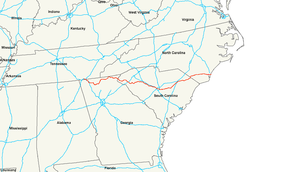
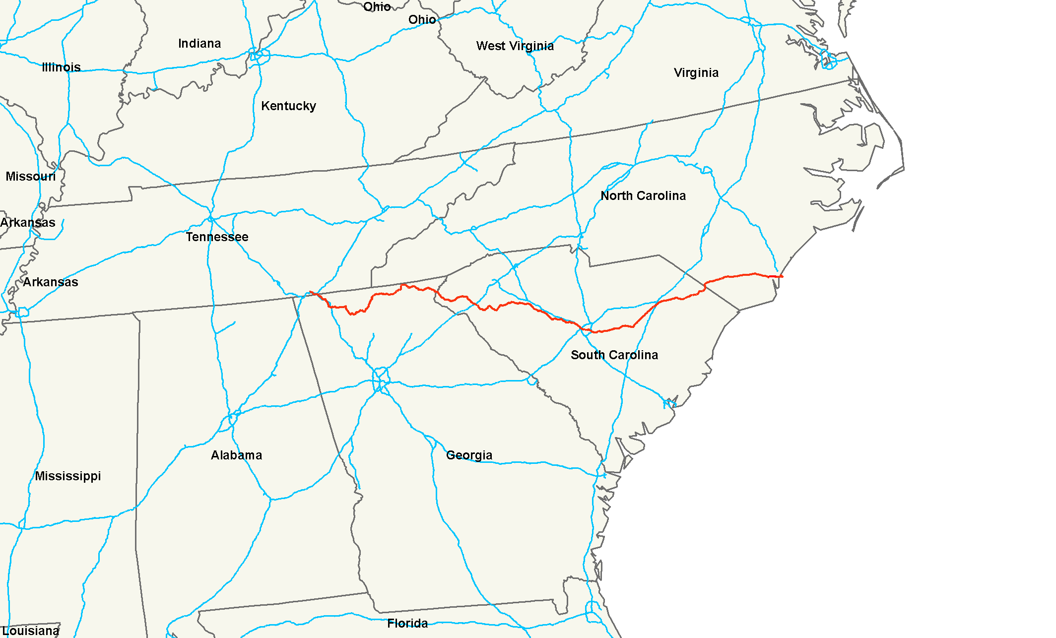
→U.S. Route 76 is an east–west United States highway that runs for 548 miles (882 km) from Chattanooga, Tennessee to Wrightsville Beach, North Carolina.
Contents
Route description
Tennessee
In the state of Tennessee, U.S. Route 76 is an arterial road that runs east-southeast from downtown Chattanooga to East Ridge and south to Georgia. U.S. 76 runs concurrent with U.S. 41 for its entire length in Tennessee, about 8.8 miles (14.2 km).[2]
Georgia
In Georgia, the highway traverses the northern part of the state and passes through the Chattahoochee National Forest and Georgia's most mountainous region. From east to west, U.S. 76 passes through Rabun, Towns, Union, Fannin, Gilmer, Murray, Whitfield, and Catoosa counties.
A significant section of US 76 was relocated in Georgia during the 1980s with the old alignment decommissioned first in 1982 from the Hemptown community in Fannin County westward and eastward into Union County in 1988. Extending from west of Blue Ridge to Blairsville, the 35-mile (56 km) stretch of road today is known as Blue Ridge Highway and Old Hwy 76 including the city of Morganton. In Morganton, the stretch is joined briefly by SR 60, and in Blairsville a small portion of the route is unofficially part of US 19/129. This old alignment from Blairsville to Blue Ridge is approximately 37 miles (60 km) long and has some of Georgia's most scenic views along its eastern end. This stretch was formerly part of SR 2 as well.
U.S. 76 also has other old alignments in Ellijay (by-passed in 1982), Cherry Log, Whitepath (both by-passed in 1989) and south of Blue Ridge (by-passed in 1965). U.S. 76 was also relocated from present-day SR 52 from Ellijay to Chatsworth in 1981 to a less treacherous course along SR 282. Significant curve realignments also occurred along the previously serpentine section from Hiawassee to Clayton from 1988 to 2005. Today US 76 shares mileage with State Routes 5, 515, 282, 61, 52, 17, 75, 15 and 3 in addition to SR 2. U.S. highways with common mileage include U.S. 411, 41, 441 and 23.
South Carolina
U.S. 76 enters South Carolina across the Chattooga River, then continues southeast toward Westminster. This segment is a moderately windy two-lane road. In Westminster, it heads east toward Seneca and Clemson. From Clemson, the road heads southeast toward Anderson, intersecting Interstate 85, then east toward the small towns of Belton and Honea Path. U.S. 76 is a four-lane highway from Westminster to Anderson. In Anderson the road widens to six lanes with a reversible turn lane. After a concurrency with U.S. 178, the road goes to five lanes, and as it goes south towards downtown Anderson, it goes back to four. However, the sections around Seneca, Clemson, and Anderson are well developed with many traffic lights. It is cosigned with U.S. 123 from Westminster to Clemson, S.C. 28 from Seneca to Anderson, and U.S. 178 from Anderson to Honea Path.
Formerly, U.S. 76 followed a longer route from Westminster to Pendleton. From Westminster, the old route followed S-37-13 through the Richland community, then its current alignment to S.C. 59 into downtown Seneca, then S.C. 130 out of Seneca to S-37-1, then its current alignment to S.C. 93 toward Clemson University, then Business S.C. 28 through Pendleton.
From Honea Path, the road heads east to Laurens. This section is a rural two lane road that is not frequently traveled. From Laurens, U.S. 76 roughly parallels I-385 and I-26 as it heads to Columbia. U.S. 76 provides local access to the communities of Laurens, Clinton, Newberry, Prosperity, Chapin and the other smaller towns in the area. In Irmo, U.S. 76 merges with U.S. 176, then continues on to I-26. After the interchange with I-20, U.S. 76 splits off from I-26 and continues into downtown Columbia cosigned with I-126.
In Columbia, U.S. 76 follows Elmwood Ave, Bull St, Gervais St., Millwood Ave., and Devine St., before heading east toward Sumter. The segment from Columbia to Sumter is a four lane highway and 76 is cosigned with U.S. 378 from the intersection of Bull and Gervais near the University of South Carolina in Columbia all the way to Sumter. From Sumter, U.S. 76 heads northeast to Florence. U.S. 76 is the major road through Florence. U.S. 76 then continues east out of Florence to the small towns of Marion and Mullins, then into North Carolina. It is cosigned with U.S. 301 from Florence to across the Pee Dee River.
North Carolina
The highway passes through Fair Bluff and becomes concurrent with US 74 from Chadbourn to Wilmington. The highway is mostly four lanes, divided with at-grade and controlled intersections. The speed limit is from 45 mph (72 km/h) to 70 mph (110 km/h). It crosses the Cape Fear Memorial Bridge into Wilmington and continues to Wrightsville Beach via Oleander Drive to the route's eastern terminus. US 76 traverses 80.3 miles (129.2 km) in North Carolina; approximately 54 miles (87 km) concurrent with US 74, between Chadbourn and Wilmington.
History
Junction list
- Mileposts reset at state line crossings.
Tennessee
Georgia
South Carolina
County Location Mile Exit Destinations Notes Horry 0.1  SC 9 east – Green Sea
East end of SC 9 overlap Marion Nichols 0.3 SC 9 west – Lake ViewWest end of SC 9 overlap Mullins 0.4 
 SC 41 / SC 917 – Smithboro, Green Sea
Marion 0.5  US 501 – Dillon, Conway
0.6 


US 501 Bus. / SC 41 Alt.0.7  SC 576 south
0.9  US 301 north – Latta
North end of US 301 overlap Florence Mars Bluff 0.10  SC 327 south – Claussen
South end of US 76/301 overlap 0.11 US 301 south / SC 327 north – EffinghamSouth end of US 301 overlap
North end of US 76 overlapFlorence 0.12  US 52 – Darlington, Effingham
0.14 I-20 Bus. west (David McLeod Blvd.) – Bishopville0.15  SC 51 south – Evergreen
0.16 I-95 – Manning, DillonTimmonsville 0.17  SC 403 north – Oats
South end of SC 403 overlap 0.19 SC 403 south – SardisNorth end of SC 403 overlap Lee Lynchburg 0.20  SC 341 – Elliot, Olanta
0.21  SC 527 – Elliot, Saradina
Sumter Mayesville 0.22  SC 154 north – St. Charles
Sumter 0.23 

 US 378 east / US 76 Bus. west – Turbeville, Sumter
East end of US 378 overlap 0.24 US 401 – Sumter, Oswego0.25 US 15 (Main St.) – Manville, Paxville0.27
US 521 east / US 76 Bus. – Rembert, Brogdon, Sumter0.29  SC 441 – Woodrow, Sumter
Stateburg 0.30  SC 261 – Horatio, Wedgefield
Richland Eastover 0.33  SC 263 south – Eastover
0.34  US 601 – Eastover, Lugoff
0.35  SC 764 south – Eastover
Horrell Hill 0.37  SC 769 south – Congaree
0.39  SC 768 south – Lykes
Columbia 0.40 I-77 – Cayce, Winnsboro0.41  SC 262 west
0.42  SC 760 (Ft. Jackson Blvd.)
0.43  SC 16 – Forest Lakes, Cayce
0.45 US 1 north – Forest AcresNorth end of US 1 overlap 0.46 US 1 south / US 378 west – West ColumbiaSouth end of US 1 overlap
West end of US 378 overlap0.48  SC 12 (Taylor St.)
0.51  SC 277 north – Dentsville
US 76 overlaps with Interstate 126 US 76 overlaps with Interstate 26 (exits 101 to 108) Ballentine 0.55 US 176 north – PeakNorth end of US 176 overlap 0.57  SC 6 east – Irmo
1.000 mi = 1.609 km; 1.000 km = 0.621 mi
Concurrency terminus • Closed/Former • Incomplete access • UnopenedNorth Carolina
County Location Mile[3] Exit Destinations Notes Columbus Fair Bluff 3  NC 904 (Conway Road) – Rowland, Tabor City
Brief .4 miles (0.64 km) concurrency Cerro Gordo 9.5  NC 242 north (Haynes Lennon Highway) – Bladenboro
Chadbourn 15 


 US 74 Bus. / US 76 Bus. east / NC 130 / NC 410 (Joe Brown Highway) – Bladenboro, Tabor City
16.5 US 74 (Andrew Jackson Highway) – LumbertonWest end of US 74 overlap, eastbound entrance and westbound exit 19 Union Valley Road – Union Valley Whiteville 22 US 701 – Whiteville, Clarkton25
US 74 Bus. west / US 76 Bus. west – WhitevilleAlso to NC 214 Bolton 39  NC 211 – Clarkton, Bolton, Supply
42  NC 214 west – Bolton
Western terminus of NC 214 Freeman 47  NC 11 north – Sandyfield
Southern terminus of NC 11 Delco 51  NC 87 north – Riegelwood
North end of NC 87 overlap Brunswick Maco 56 NC 87 south – BishopSouth end of NC 87 overlap Leland 61 Lanvale Road – Leland 65 US 17 south – Town Creek, WinnabowSouth end of US 17 overlap 65.5  NC 133 south – Belville, Southport
South end of NC 133 overlap 67.5  US 17 north / US 74 east / US 421 north / NC 133 north – Jacksonville, Wrightsville Beach, Clinton
 To I-140
North end of US 17/US 421/NC 133 overlap, east end of US 74 overlap, south end of US 17 Business overlap New Hanover Wilmington 68.5
US 421 south (Third Street) / US 17 Bus. north – Carolina BeachSouth end of US 421 overlap, north end of US 17 Business overlap 72 
 US 117 / NC 132 (College Rd.) – Carolina Beach, Castle Hayne
76 US 74 west (Eastwood Road)West end of US 74 overlap Wrightsville Beach 77.5 US 74 east (Salisbury Street)East end of US 74 overlap 78.5 Waynick Boulevard End of US 76 is 1.7 miles (2.7 km) from intersection, south on Waynick Boulevard/Lumina Avenue 1.000 mi = 1.609 km; 1.000 km = 0.621 mi
Concurrency terminus • Closed/Former • Incomplete access • UnopenedBannered routes
South Carolina business loops
There are two U.S. Route 76 business loops in South Carolina:
North Carolina business loop
There is one U.S. Route 76 business loop in North Carolina:
- Whiteville – A 10.5-mile (16.9 km) route through the cities of Chadbourn and Whiteville.[4]
See also
Related U.S. routes
References
- ^ a b Droz, Robert V. U.S. Highways: From US 1 to (US 830). URL accessed 1 March 2006.
- ^ Google Maps estimate
- ^ Google, Inc. Google Maps – US 76 in NC (Map). Cartography by Google, Inc. http://maps.google.com/maps?f=d&source=s_d&saddr=US-76+E&daddr=S+Lumina+Ave&hl=en&geocode=FaL7CgId4OxJ-w%3BFYupCQIds7Jc-w&mra=dme&mrsp=1&sz=16&sll=34.190914,-77.804618&sspn=0.013259,0.027874&ie=UTF8&ll=34.250406,-78.457489&spn=0.847942,1.783905&z=10. Retrieved 2011-02-27.
- ^ Google, Inc. Google Maps – US 76 Bus - Whiteville (Map). Cartography by Google, Inc. http://maps.google.com/maps?f=d&source=s_d&saddr=US-76+E&daddr=34.3334015,-78.7714428+to:US-76+BUS+E%2FRed+Hill+Rd%2FUS-74+BUS+E&hl=en&geocode=FRDsCwIdOjJN-w%3BFdniCwIdDgtO-ynfVBDFx4yqiTH0lOdwLGK-Mg%3BFRkjDAIdicZP-w&mra=dme&mrsp=2&sz=15&via=1&sll=34.348007,-78.655243&sspn=0.026468,0.055747&ie=UTF8&ll=34.345704,-78.747253&spn=0.105874,0.222988&z=13. Retrieved 2011-02-27.
 Main U.S. Routes
1 2 3 4 5 6 7 8 9 10 11 12 13 14 15 16 17 18 19 20 21 22 23 24 25 26 27 28 29 30 31 32 33 34 35 36 37 38 40 41 42 43 44 45 46 48 49 50 51 52 53 54 55 56 57 58 59 60 61 62 63 64 65 66 67 68 69 70 71 72 73 74 75 76 77 78 79 80 81 82 83 84 85 87 89 90 91 92 93 94 95 96 97 98 99 101 163 400 412 425 Lists U.S. Routes • Bannered • Divided • Bypassed Categories:- U.S. Highway System
- U.S. Highways in North Carolina
- U.S. Highways in South Carolina
- U.S. Highways in Georgia (U.S. state)
- U.S. Highways in Tennessee
- Transportation in Rabun County, Georgia
- Transportation in Columbus County, North Carolina
- Transportation in Brunswick County, North Carolina
- Transportation in New Hanover County, North Carolina

Wikimedia Foundation. 2010.