- Selway-Bitterroot Wilderness
Infobox_protected_area | name = Selway-Bitterroot Wilderness
iucn_category = Ib
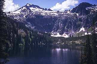
caption = Isolated lake in the Selway-Bitterroot Wilderness
locator_x =
locator_y =
location =Idaho , USAMontana , USA
nearest_city =Darby, Montana
lat_degrees = 46
lat_minutes = 12
lat_seconds = 45
lat_direction = N
long_degrees = 114
long_minutes = 20
long_seconds = 46
long_direction = W
area = 1,340,460 acres (5,424 km²)
established =January 1 ,1964
visitation_num =
visitation_year =
governing_body =U.S. Forest Service The Selway-Bitterroot Wilderness is a protected
wilderness area in the states ofIdaho andMontana , in the northwesternUnited States .At 1.3 million acres (5,300 km²), it is one of the largest designated wilderness areas in the United States. It spans the Bitterroot Mountain Range, on the border between Idaho and Montana. It covers parts of
Bitterroot National Forest ,Clearwater National Forest ,Lolo National Forest , and theNez Perce National Forest . TheFrank Church-River of No Return Wilderness Area is immediately to its south, separated only by a dirt road (the Magruder Corridor). Together with adjoining unprotected public land, the two wilderness areas form a five million acre (20,000 km²) wild region.It is here that the Lochsa and Selway rivers join to form the
Clearwater River . The land ranges in elevation from 1700 feet (520 m) on the Lochsa River to 10,157 foot (3,100 m) at Trapper Peak in the Bitterroot Mountains.One of the largest
elk herds in the United States calls the wilderness home, and it also boasts a healthy population ofbighorn sheep . This wilderness is one of the areas being used to reintroduce wild packs of thegrey wolf .The high-elevation areas around the Bitterroot peaks are rugged alpine parkland. Lower areas are covered by dense coniferous forest.
ee also
*
List of U.S. Wilderness Areas
*Wilderness Act External links
* [http://www.explorethebitterroot.com/selway_bitterroot_wilderness.htm Selway-Bitterroot Wilderness Information & Maps]
* [http://www.fs.fed.us/r1/bitterroot/recreation/wilderness/selway_bitterroot.htm Selway-Bitterroot Wilderness] —Information from the Bitterroot National Forest
* [http://www.wilderness.net/index.cfm?fuse=NWPS&sec=wildView&wname=Selway-Bitterroot Wilderness.net]
* [http://www.topoquest.com/map.asp?z=11&n=5132020&e=697581&s=50&size=l&u=7&datum=nad83&layer=DRG25 TopoQuest]
* [http://www.npr.org/programs/re/archivesdate/2004/sep/selway/ National Public Radio] report on the Wilderness Act from the Selway-Bitterroot Wilderness]
Wikimedia Foundation. 2010.