- U.S. Route 92
Infobox road
state=FL
type=US
route=92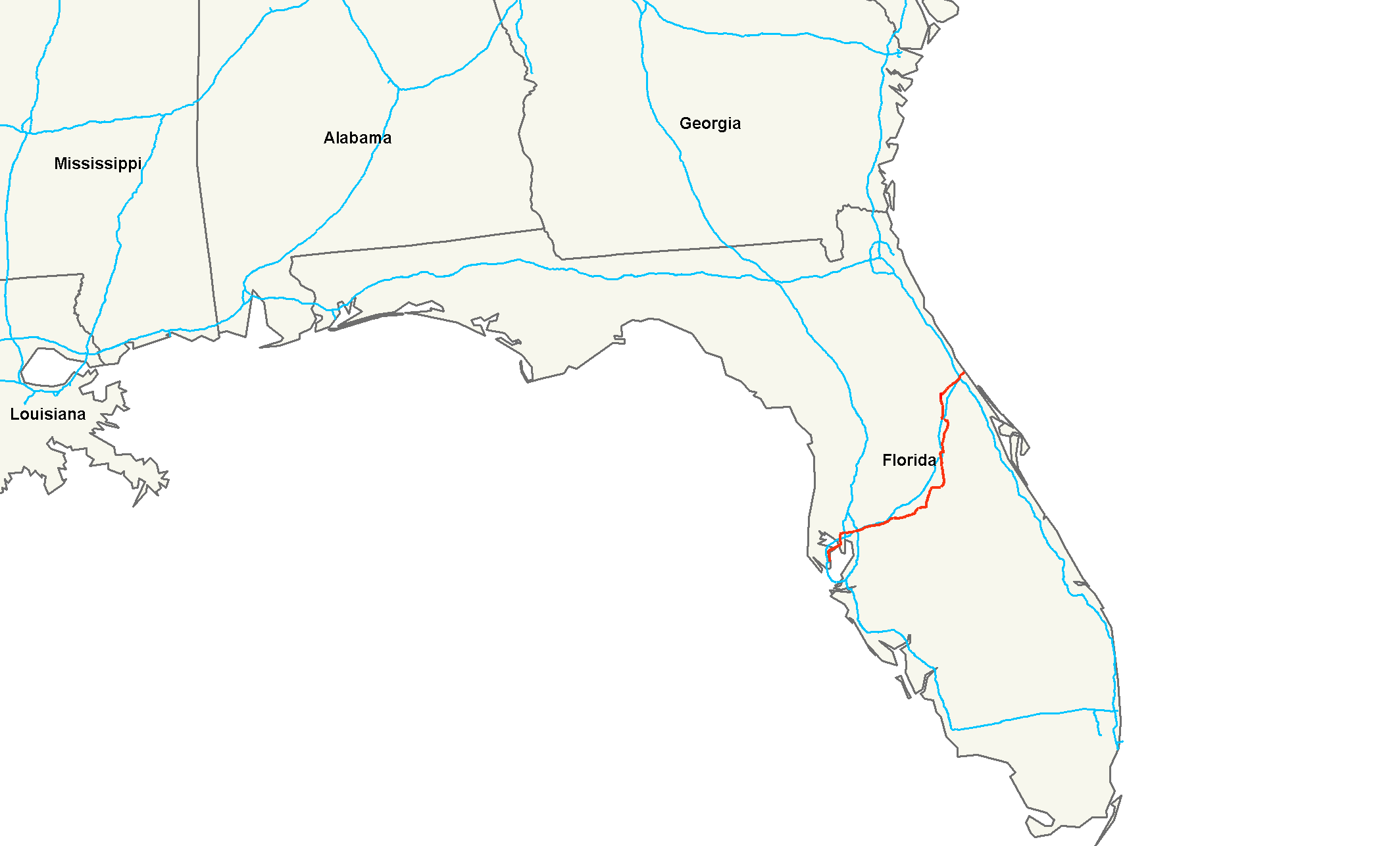
length_mi=177
length_ref=Droz, Robert V. [http://www.us-highways.com/usbt.htm U.S. Highways : From US 1 to (US 830)] . URL accessed 02:55, 4 July 2006 (UTC).]
length_round=0
yrcom=1926
direction_a=West
direction_b=East
starting_terminus=Jct|state=FL|US-Alt|19|FL|595|FL|687|dab1=St. Petersburg in St. Petersburg
junction=Jct|state=FL|I|275 in Tampa
Jct|state=FL|US|41 in Tampa
Jct|state=FL|I|4 "(numerous locations)"
Jct|state=FL|US|98 in Lakeland
Jct|state=FL|US|17 from Lake Alfred to DeLand
Jct|state=FL|US|27 in Haines City
Jct|state=FL|US|192 in Kissimmee
Jct|state=FL|US|441 from Kissimmee to Orlando
Jct|state=FL|I|95 in Daytona Beach
ending_terminus=Jct|state=FL|FL|A1A in Daytona Beach
previous_type=FL
previous_route=597
browse_route=
next_type=FL
next_route=607U.S. Route 92 is a 177 mile (285 km) intrastate
U.S. Route in theU.S. state ofFlorida . The western terminus is at Alt US 19, SR 595, and SR 687 in downtown St. Petersburg. The eastern terminus is at SR A1A in Daytona Beach. Most of US 92 is designated unsigned State Road 600.Route description
US 92 is concurrent with SR 687 from downtown St. Petersburg to SR 600, SR 686 and SR 694 at the west end of the Gandy Causeway; unsigned SR 600 from the west end of the Gandy Causeway to west of downtown Lakeland; unsigned State Road 517 west of downtown Lakeland; SR 546 from west of downtown Lakeland to east of downtown Lakeland; and unsigned State Road 600 from east of downtown Lakeland to Daytona Beach.
In Seminole County, the redevelopment of the 17-92 Community Redevelopment Area is handled by the
US 17-92 Community Redevelopment Agency , a component unit of the County government.US 92 runs concurrent with US 17 for a large portion of its length, until the two roads separate in DeLand. From its separation point in DeLand to its terminus in Daytona Beach, the route carries the local name, "International Speedway Boulevard," as the highway passes by the
Daytona International Speedway . US 92 passes by other landmarks such asDaytona Beach International Airport andVolusia Mall .History
US 92 was in the original 1926 plan, connecting Tampa (concurrent with US 41) to US 1 in Daytona Beach. It had been the
Dixie Highway Tampa-St. Petersburg Loop from Plant City to Haines City, the West Mainline from Haines City to Orlando, and the East Florida Connector from Orlando to DeLand.US 92 was signed along the following roads in 1927:
* SR 17 from Tampa to Haines City
* SR 2 from Haines City to Orlando
* SR 3 from Orlando to DeLand
* SR 21 from DeLand to Daytona BeachWhen the bypass of downtown Tampa on SR 17 (Hillsborough Avenue) opened in the early
1930s , US 92 and US 41 were rerouted to use it. US 92 turned south from the new road where US 41 turned north, at Nebraska Avenue (former SR 5, probably then a spur of SR 5), and continued to end in downtown Tampa.A 1942 map shows US 92 extended west along SR 17 and SR 229 to end at US 19 in Dunedin; it was soon truncated back to Tampa.
In the 1945 renumbering, the whole route of US 92 was numbered SR 600, except for the section south to downtown Tampa, which was SR 45. It was extended west and south to downtown St. Petersburg along SR 600 and SR 687 in
1953 .In
1961 , US 92 was moved to bypass downtown Lakeland, along SR 517 and SR 546. The old route was signed as Business US 92 until1998 .The date of extension east across the
Intracoastal Waterway is unknown.Major intersections
* Selmon-Crosstown Expressway in Tampa
* State Road 60 in Tampa
* I-275 in Tampa
* Business US 41 in Tampa
* I-275 in Tampa
* US 41 in Tampa "(begin US 41 concurrency)"
* US 41 in Tampa "(end US 41 concurrency)"
* I-4/US 301 east of Tampa
* I-75 east of Tampa "no access"
* US 98 in Lakeland "(begin US 98 concurrency)"
* US 98 in Lakeland "(end US 98 concurrency)"
* US 17 south of Lake Alfred "(begin US 17 concurrency)"
* US 27 in Haines City as US 17-92
* US 192 (Vine Street) in Kissimmee "(begin US 192 concurrency)"
* US 192/US 441 (Vine Street/Main Street) in Kissimmee "(end US 192 concurrency; begin US 441 concurrency)"
* I-4 in Orlando
* US 441 (Orange Blossom Trail ) in Orlando "(end US 441 concurrency at SR 50)"
* SR 436 in Casselberry
* I-4 in Sanford
* US 17 in DeLand "(end US 17 concurrency)"
* I-4 west of Daytona Beach "(connector ramp)"
* I-95 west of Daytona Beach
* US 1 in Daytona Beachee also
*
U.S. Route 17/92 Bannered routes
*"U.S. Route 92 Business" in Lakeland
*"U.S. Route 92 Truck" in Kissimmee
*U.S. Route 92 Truck in Winter ParkRelated routes
*U.S. Route 192
References
Wikimedia Foundation. 2010.