- Sutton-in-Ashfield
-
Coordinates: 53°07′24″N 1°16′01″W / 53.1233°N 1.2669°W
Sutton-in-Ashfield 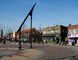
The Sutton-in-Ashfield sundial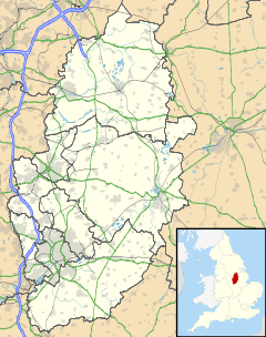
 Sutton-in-Ashfield
Sutton-in-Ashfield shown within NottinghamshirePopulation 41,951 OS grid reference SK490587 District Ashfield Shire county Nottinghamshire Region East Midlands Country England Sovereign state United Kingdom Post town Sutton-in-Ashfield Postcode district NG17 Dialling code 01623 Police Nottinghamshire Fire Nottinghamshire Ambulance East Midlands EU Parliament East Midlands UK Parliament Ashfield List of places: UK • England • Nottinghamshire Sutton-in-Ashfield is a market town in the Ashfield district of Nottinghamshire, England, with a population of around 43,000.[1] It is situated four miles west of Mansfield, close to the Derbyshire border.
Contents
Geography
For demographic purposes it is part of Mansfield Urban Area, although in the separate council district of Ashfield, (based in Kirkby-in-Ashfield). To the north is Skegby and Stanton Hill.
The main road to Mansfield used to go through the town, but this is now the B6023 road. The A617 Mansfield Bypass meets the A38 at Kings Mill and passes through much of the town's parish, to the east. It opened in 2005.
Landmarks
The main tourist attraction in Sutton-in-Ashfield, is the largest sundial[2] in Europe. It is located in the middle of Portland Square, adjacent to the Idlewells Shopping Centre and Sutton Centre Community College.
Another tourist attraction in Sutton-in-Ashfield is The Ashfield Show, held in August on Sutton Lawn, and includes everything from fairground rides, local businesses and services showing their presence, live music, classic cars and steam engines and much more.
A further local attraction stands on the former site of Silverhill Colliery close to the scenic village of Teversal on the north-west edge of Ashfield. The area has been transformed from the colliery to a woodland, which features several walks for all abilities and also features the highest point in Nottinghamshire[citation needed]. At the highest point stands a monument to all the miners who have worked in the area's coalfields.
King's Mill Hospital is the main landmark, situated between the town and Mansfield, next to the A38. The town has a large Asda to the north of the town centre and a Morrisons towards Mansfield, off the A38. In April 1999, the Asda supermarket had the UK's first blessing and reception in a supermarket. It had been unable to get a ceremony licence for the supermarket.
Out on the B6139 to the south is the Sherwood Observatory, which is inside the parish, not Mansfield, being run by the Mansfield and Sutton Astronomical Society.
History
Saxons
The area was first settled in Saxon[citation needed] times and the Saxon suffix "ton" means "an enclosure or fenced in clearing". The town appears in the Domesday Book as "Sutone". There are also documents from 1189 showing that Gerard, son of Walter de Sutton, gave two bovates of land and the church at Sutton to Thurgarton Priory.
Churches
The Church of St. Mary Magdalene, Sutton-in-Ashfield dates from the twelfth century[citation needed].
Coal mining
Sutton Colliery was actually outside of the town in Stanton Hill. It closed in 1989.
Hosiery
The Pretty Polly brand of hosiery originated in the town in around 1927, and was manufactured there on Unwin Road until April 2005. Samuel Eden Socks closed in July 2005.
Transport
Road
Sutton-in-Ashfield is served by regular bus services from Nottingham, Mansfield and Derby. Sutton Parkway railway station (Robin Hood Line) is two miles south of the town centre. The town is close to Junction 28 of the M1 motorway along the A38. The town's bypass is a wide single-carriageway.
Rail
The town, since 1995, is now on the Robin Hood Line with Sutton Parkway railway station which is a good two miles from the town centre - although near the A38 bypass, towards Kirkby-in-Ashfield on the B6021 road. The railway was formerly mostly used by the area's pits, which closed in the early 1990s.
Recreation
Sport
Sutton use to have a large and ageing swimming pool, with a (rare) high diving board, at the Sutton Pools Complex which closed, to be replaced directly by the new £16m Lammas Leisure Centre which was opened on 1 November 2008 by Kelly Holmes. There is a local athletics club and swimming club. There is also Coxmoor Golf Club on Coxmoor Road (B6139) next to the A611. Sebastian Coe opened a new athletics track for the town at the nearby Ashfield School in February 2007.
Kings Mill Reservoir
The reservoir is in Sutton-in-Ashfield, not Mansfield, and has the Mill Adventure Base with sailing activities. This is one of three Nottinghamshire adventure bases, with the other two at Holme Pierrepont (Lakeside) and Worksop (Sandhill) and are for people from 11-19. The sailing club has used the reservoir since 1959. Kings Mill received its name from a mill on the north-east of the rervoir owned by John Cockle and his wife, who gave Henry II of England a night's lodgings and breakfast.
Nature
To the west is the 250 acres (100 ha) Brierley Forest Park,[3] built on the site of Sutton Colliery, also known as Brierley Colliery, which was named due to many of the miners coming from Brierley Hill. It is a nature reserve and opened in 1999, it hold the Green Flag Award.[4] Kings Mill Reservoir is also a nature reserve.
Schools
- Mapplewells Primary and Nursery School - Ages 3 to 11
- Lammas School - Ages 5 to 16
- Quarrydale School - Ages 11 to 18
- Forest Glade Primary School - Ages 4 to 11
- St. Mary Magdalene C of E Primary School - Ages 4 to 11
- Carsic Infants School
- Carsic Juniors School
- Croft Primary School
- Leamington Primary and Nursery School - Ages 3 to 11
- Dalestorth Primary School
- Sutton Centre Community College - Ages 11 to 18, with courses for adults
- Hillocks Primary & Nursery School
- Priestsic Primary School
- St Andrews C of E Primary & Nursery School - Ages 4 to 11
The Ashfield Comprehensive School is also very near the town, on the other side of the A38 (Kings Mill Road East East).-
 Sutton-in-Ashfield open air market (Tuesdays, Fridays and Saturdays)
Notable people from the town
- Pascal Broadley, cricketer
- Kris Commons, footballer for Stoke City, Nottingham Forest, and Derby County.
- Chris Gascoyne, Coronation Street actor
- Andrew Lewis, composer
- Jeremiah Brandreth, last person to be publicly beheaded with an axe in the UK in 1817.
- Trevor Ashmore, famous for his museum quality forgeries of Anglo-Saxon and early English coinage.
- Jimmy Walker, football goalkeeper previously of Walsall and West Ham.
- Alex Baptiste, football defender for Blackpool F.C.
- Michael Willetts, one of the first British soldiers to be killed during the The Troubles in Northern Ireland.
- Arthur Betts (b.1917), Nottingham Forest footballer
- Horace Burrows, footballer for Sheffield Wednesday and England
- Steve Ogrizovic, football goalkeeper for Chesterfield, Shrewsbury, Liverpool and Coventry City
References
External links
- Ashfield District Council
- A History of Sutton-in-Ashfield
- Rambling Club
- Kings Mill Reservoir
- Kings Mill Reservoir for visitors from Nottingham
Ceremonial county of Nottinghamshire Unitary authorities Boroughs or districts Major settlements Arnold · Beeston · Bingham · Bircotes · Blidworth · Carlton · Cotgrave · Eastwood · Harworth · Hucknall · Kimberley · Kirkby-in-Ashfield · Mansfield · Mansfield Woodhouse · Netherfield · Newark · Nottingham · Ollerton · Rainworth · Retford · Ruddington · Stapleford · Southwell · Sutton-in-Ashfield · West Bridgford · Worksop
See also: List of civil parishes in NottinghamshireTopics Categories:- Towns in Nottinghamshire


Wikimedia Foundation. 2010.