- Crewkerne Castle
-
Crewkerne Castle Crewkerne, Somerset 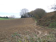
Possible earthwork ramparts of Crewkerne Castle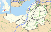
 Shown within Somerset and the British Isles
Type Possible motte and bailey Coordinates grid reference ST420107 Crewkerne Castle (which is also known as Castle Hill, Croft Castle or Crow Castle) was possibly a Norman motte and bailey castle on a mound that is situated north-west of the town of Crewkerne in Somerset, England.
Contents
Details
Crewkerne Castle a 450 feet (140 m) high outcrop[1] that since at least 1839 has been termed a castle site.[2] Archaeological and geophysical research has found a ditch around the hilltop, with a masonry square within it, while fragments of 12th century pottery have been found on the site.[2] One theory is that this is a Norman motte; another that it is a 13th century manor house;[3] alternatively it may be simply have been a local folly.[2]
The manor had been granted to Richard de Redvers by Henry I by the year 1107 and it is thought that his son Baldwin built on the hill. In 1150 the Bishop of Salisbury was given the services of knights associated with the castle.[4]
See also
- Castles in Great Britain and Ireland
- List of castles in England
References
- ^ "Croft Castle, Castle Hill, West Crewkerne". Somerset Historic Environment Record. Somerset County Council. http://webapp1.somerset.gov.uk/her/details.asp?prn=54678. Retrieved 15 July 2011.
- ^ a b c Croft Castle Crewkerne, Gatehouse website, accessed 12 July 2010.
- ^ Richardson, Miranda. "An archaeological assessment of Crewkerne". English Heritage Extensive Urban Survey. Somerset County Council. http://www1.somerset.gov.uk/archives/hes/downloads/EUS_CrewkerneText.pdf. Retrieved 15 July 2011.
- ^ Dunning, Robert (1995). Somerset Castles. Tiverton: Somerset Books. pp. 35–37. ISBN 978-0861832781.
Further reading
- Fry, Plantagenet Somerset, The David & Charles Book of Castles, David & Charles, 1980. ISBN 0-7153-7976-3
Categories:- Castles in Somerset


Wikimedia Foundation. 2010.