- U.S. Route 441
Infobox U.S. Route
article_route=441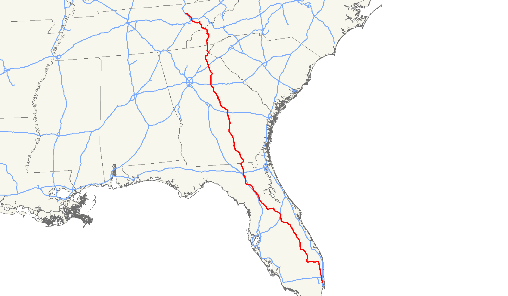
length_mi=939
length_round=0
length_ref=
yrcom=1926
direction_a=South
from=Jct|state=FL|US|41 in Miami, FL
junction=
direction_b=North
to=Jct|state=TN|US|25W|sec|116 in Lake City, TN
spur_of=41U.S. Route 441 is a
spur route ofU.S. Route 41 . It currently runs for 939mile s (1,511 km) fromU.S. Route 41 inMiami, Florida toU.S. Route 25W inLake City, Tennessee . Between its termini, US 441 passes through the states ofFlorida , Georgia,North Carolina , andTennessee . The route acts as a connector between numerous major urban areas, including Miami, Orlando, Ocala, Gainesville, Athens and Knoxville. It also crosses theGreat Smoky Mountains National Park , where it meets the southwestern end of theBlue Ridge Parkway , and where notruck s or other commercialtraffic are allowed.Route description
Florida
US 441 begins at an intersection with U.S. Route 41 in downtown Miami. The route parallels Interstate 95 north out of Miami to western Aventura, where I-95 heads northeast to access Fort Lauderdale and the remainder of the eastern Florida coast. However, the route is soon joined by the tolled
Florida's Turnpike , which follows US 441 north to West Palm Beach. In between, the route interchanges with the Turnpike at exit 62 via State Road 870 in Tamarac. Additionally, US 441 meets Interstate 595 west of Fort Lauderdale and the tolled State Road 869 in Coconut Creek.At West Palm Beach, US 441 intersects U.S. Route 98 and overlaps the highway to central Palm Beach County, where the two routes split. US 441 continues west to the eastern shore of
Lake Okeechobee , where it turns north to follow the shoreline to Pahokee. Just north of Pahokee, US 98 rejoins US 441 and remains concurrent with US 441 along the eastern edge of the lake. North of Lake Okeechobee in Okeechobee, US 98 and 441 split for the final time. US 441 continues north, meeting the Turnpike at Yeehaw Junction (via State Road 60) prior to intersecting U.S. Route 192 at Holopaw. US 441 turns west onto US 192, forming an overlap into Kissimmee. At the concurrent routes ofU.S. Route 17/92 , US 441 separates from US 192 and follows US 17/US 92 north into downtown Orlando. In downtown, US 17/92 turns east onto State Road 50 while US 441 continues north on the Orange Blossom Trail. North of downtown, US 441 meets the northern terminus of the tolled State Road 429 before leaving the Orlando area.In Leesburg, midway between Orlando and Ocala, US 441 intersects U.S. Route 27. Here, the routes come together, creating a concurrency north to the Ocala suburb of Belleview, where US 27 and US 441 intersect U.S. Route 301. US 301 turns north onto US 27/441, overlapping the routes into Ocala. Immediately north of downtown, US 27 separates from US 441; US 301 then departs the route north of the city. US 441 continues to the northwest, passing through Gainesville and interchanging with Interstate 75 ahead of an intersection with US 41 in High Springs. US 441 joins US 41 north to Lake City, where the routes split south of the city. The routes remain parallel, however, past U.S. Route 90 to the northern extents of Lake City.
Past Lake City, US 441 interchanges with Interstate 10, then skirts the western edge of the
Okefenokee Swamp as it enters Georgia.The section from Miami to West Palm Beach is paired with unsigned State Road 7, and the section from Holopaw to Ocala is paired with unsigned State Road 500. From SR 121 in Gainesville to US 90 in Lake City, it is part of the DeSoto Trail.
Georgia
In Georgia, US 441 continues to circumnavigate the Okefenokee Swamp to Edith, where it turns to the northwest toward the interior of the state. In Homerville, US 441 intersects
U.S. Route 84 , then meets and merges withU.S. Route 221 south of Pearson. The routes remain concurrent to Douglas, where US 221 and US 441 split. Farther north, US 441 intersectsU.S. Route 319 south of Jacksonville. US 319 turns north onto US 441, creating an overlap north to McRae. US 319 and US 441 intersectU.S. Route 280 , which joins the routes for a concurrency through McRae. In the center of McRae, US 280, US 319 and US 441 meet the concurrent routes ofU.S. Route 23 andU.S. Route 341 . North of the city, US 280 splits off while US 319 and US 441 continue concurrently to Dublin. Just south of Dublin, US 319 and US 441 interchange withInterstate 16 . In Dublin, US 319 and US 441 briefly overlap withU.S. Route 80 before US 441 separates from both routes and exits the area.North of Dublin, US 441 passes through Milledgeville prior to meeting
U.S. Route 129 near Eatonton. US 129 and US 441 continue concurrently through Madison (where US 129 and US 441 interchange withInterstate 20 ) to Athens, where US 129 and US 441 turn eastward onto a limited-access beltway encircling the city. On the beltway, US 129 and US 441 run concurrent withU.S. Route 29 and, for a stretch,U.S. Route 78 to an interchange northeast of the city. Here, US 29 exits the highway while US 441 remains on the beltway for two more exits before departing.The route proceeds north to Commerce, where it interchanges with
Interstate 85 north of the city. Past Commerce, US 441 continues to Cornelia, where it intersectsU.S. Route 23 . US 441 merges with US 23, remaining concurrent with the route through Clayton (where US 23 and US 441 are concurrent withU.S. Route 76 for a short distance) intoNorth Carolina . The portion of US 23/US 441 fromU.S. Route 123 west of Toccoa to the North Carolina state line is located within theChattahoochee National Forest .North Carolina
Upon crossing the state line, US 23 and US 441 enter the
Nantahala National Forest . The concurrent routes head north through a pair of small communities before intersectingU.S. Route 64 in Franklin. US 23 and US 441 turn east, briefly overlapping US 64 around Franklin before separating from the route and continuing to the northeast through the forest. At Dillsboro, US 23 and US 441 intersectU.S. Route 74 , here alimited-access highway . US 23 and US 441 both merge onto the freeway, becoming concurrent with US 74; however, US 23 follows US 74 east toward Asheville while US 441 utilizes US 74 west. Near Qualla, the overlap with US 74 comes to an end as US 441 departs the freeway as well as the forest.US 441 heads north to Cherokee, a town located within the
Eastern Cherokee Indian Reservation , where it briefly overlapsU.S. Route 19 through the town center. Past Cherokee, US 441 progresses north through the reservation to the southern extent of theGreat Smoky Mountains National Park , a dual-state park situated on the North Carolina-Tennessee border. From the park entrance to theTennessee state line, the route follows a northwesterly alignment as it traverses theGreat Smoky Mountains .Tennessee
US 441 enters Tennessee at
Newfound Gap . The route heads north through the Great Smoky Mountains National Park to Gatlinburg, where the route meetsU.S. Route 321 . US 321 joins US 441 northward through Pigeon Forge before separating north of the city. US 441 continues north to Sevierville, where it intersects withU.S. Route 411 . US 441 turns west onto US 411, following the route west to Seymour. Here, US 411 heads to the southwest towards Georgia while US 441 continues northwest to Knoxville.Immediately south of the city, US 441 junctions with State Route 33. SR 33 merges with US 441, following the U.S. route as it enters downtown Knoxville. Within downtown, US 441 interchanges with
Interstate 40 and Interstate 640 before exiting the city limits. North of the city at Halls Crossroads, SR 33 breaks from US 441 and heads northeast toward New Tazewell. US 441, meanwhile, continues northeast, parallelingInterstate 75 for a distance before crossing the top ofNorris Dam and finally interchanging with the freeway at exit 128 near Lake City. The route then terminates at an intersection withU.S. Route 25W just west of I-75 in Lake City.The route is paired with unsigned State Route 71 for most of its length in Tennessee.
History
In
Florida , where signs for U.S. Highways formerly had different colors for each highway (until the state was forced by the federal government to conform to standards that required consistent black-and-white signs), the "shield" for US 441 was brown.Although the southern terminus of US 441 is US 41 in Miami, the current, temporary terminus has been the Miami River since early 2007, when the Florida Department of Transportation demolished the NW 7th Avenue Bridge over which the highway passed. The replacement bridge will not be finished until 2011. [ [http://www.miamiherald.com/news/miami_dade/story/208801.html "Bridge work stymies Dade Civic Center area,"] Larry Lebowitz, "Miami Herald", August 20, 2007.]
Popular Culture References
Route 441 is mentioned in the song "American Girl," by
Tom Petty and the Heartbreakers. ("She could hear the cars roll by/Out on 441/Like waves crashin' on the beach") Petty is fromGainesville, Florida and Route 441 runs along theUniversity of Florida campus where the song takes place.References
External links
* [http://www.geocities.com/usend4049/End441/end441.htm Endpoints of U.S. highways (Ends of 441)]
* [http://www.us-highways.com/flus441.htm US 441 @ Florida in Kodachrome]
* Tennessee section - [http://www.milebymile.com/main/United_States/Tennessee/United_States_441_1/United_States_Tennessee_road_map_travel_guides.html I-40 (exit 407) to the Great Smoky Mountains]
* North Carolina section - [http://www.milebymile.com/main/United_States/North_Carolina/United_States_441_1/United_States_North_Carolina_road_map_travel_guides.html Newfound Gap (Tennessee and North Carolina State line) to Cherokee]
* Georgia section - [http://www.milebymile.com/main/United_States/Georgia/United_States_441_1/United_States_Georgia_road_map_travel_guides.html North Carolina/Georgia State Line to Florida/Georgia State Line]
* Florida section - [http://www.milebymile.com/main/United_States/Florida/United_States_441_1/United_States_florida_road_map_travel_guides.html Florida/Georgia State Line to Miami]
* [http://www.athens441.com/ Athens 441] - Radio show produced byWUGA-FM and distributed throughGeorgia Public Broadcasting
* [http://www.sed.uga.edu/pso/programs/441.html 441 Heritage Program] at theUniversity of Georgia School of Environmental Design ###@@@KEYEND@@@###
Wikimedia Foundation. 2010.