- U.S. Route 250
-
U.S. Route 250
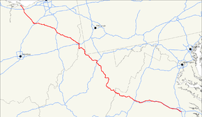
Route information Auxiliary route of US 50 Length: 514 mi (827 km) Existed: 1928 – present Major junctions West end:  US 6 in Sandusky, OH

 I-80 / I-90 / Ohio Tpk. near Milan, OH
 I-71 near Ashland, OH
 US 30 near Wooster, OH
 I-77 near Strasburg, OH

 I-70 / WV 2 in Wheeling, WV
 I-79 near Fairmont, WV

 US 33 / US 219 near Elkins, WV
 I-81 near Staunton, VA
 I-64 near Waynesboro, VA
 US 29 in Charlottesville, VA US 33 in Richmond, VA
East end:  US 60 in Richmond, VA
Highway system United States Numbered Highways
List • Bannered • Divided • ReplacedU.S. Route 250 (US 250) is a route of the United States Numbered Highway System, and is a spur of U.S. Route 50. It currently runs for 514 miles (827 km) from Sandusky, Ohio to Richmond, Virginia. It passes through the states of Virginia, West Virginia, and Ohio. It goes through the cities of Richmond, Virginia, Charlottesville, Virginia, Staunton, Virginia, and Wheeling, West Virginia. West of Pruntytown, West Virginia, US 250 intersects and forms a short overlap with its parent US 50. In West Virginia, the route is signed north–south. In Ohio and Virginia, the route is signed east–west.
Contents
Route description
Ohio
In Ohio, U.S. 250 is an important cross-state corridor linking Sandusky (on Lake Erie) to Bridgeport (on the Ohio River). From a regional/traffic perspective, the route can roughly be divided into four sections linking major regions and routes of the state:
- US 6 in Sandusky to US 20 at Norwalk
- US 20 at Norwalk to US 30 at Wooster
- US 30 at Wooster to I-77 at Strasburg
- I-77 at New Philadelphia to US 22 at Cadiz
- US 22 at Cadiz to I-70 at Bridgeport
Sandusky to Norwalk
U.S. Route 250 begins in Sandusky, Ohio at an intersection with U.S. Route 6 (Cleveland Road). It begins carrying the name Sycamore Line, but US 250 leaves this road shortly for Milan Road. This part of the route carries much traffic connecting to the Ohio Turnpike, and during the summer, people bound for Cedar Point. It is the most heavily developed section of the road, lined with big box stores, a regional shopping mall, an outlet mall, and numerous hotels, indoor waterparks and restaurants.
US 250 crosses Ohio Route 2 as it travels south and eventually crosses the Ohio Turnpike on Interstate 90 and Interstate 80. It then picks up Ohio State Route 13 before passing west of Milan. After a short stretch, it enters Norwalk on Milan Avenue. It turns onto League Street and travels southwest to Whittlesey Avenue, which becomes Benedict Avenue as the street travels southeast through the center of the city.
Norwalk to Wooster
Much of this section of the route is rural, but carries a high level of truck and regular traffic. US 250 exits Norwalk and crosses US 20/SR 18 (Norwalk Bypass) at a diamond interchange. The route heads in a generally southeasterly direction until Fitchville, where it enters on Wooster Street. SR 13 finally separates from US 250 before the latter turns onto Mill Street Extension, turning south off said road shortly after.
US 250 continues southeast until it meets SR 60, and the two routes enter Savannah on North Main Street and pass straight through town. They continue together toward Ashland, where it meets an intersection with Cottage Street. SR 60 continues south on Cottage Street, while US 250 turns east, meeting US 42 east of the city and forming an overlap as it turns south. Upon meeting Main Street, US 250 leaves US 42 at an interchange and turns east. It passes through sparse development outside the city until it interchanges with Interstate 71.
US 250 continues east on Ashland Road in open countryside, passing through small communities. West of Wooster, US 250 enters US 30, carrying the name Lincoln Way, and bypasses the city to the south, exiting at a partial cloverleaf interchange which sends it south on SR 83. US 250 then turns east on Dover Road south of the city.
Wooster to Strasburg
On Dover Road, US 250 follows a two-lane alignment as it passes through mostly open fields on its path to Strasburg. The route forms the main streets of several communities as it passes through them, such as Apple Creek, Mount Eaton, and Wilmot. It intersects OH 21 just before entering town, which it does on Wooster Avenue. This densely-populated stretch of US 250 in Strasburg has been proposed for a bypass, but the project has not been selected for further work as of 2008.[1]
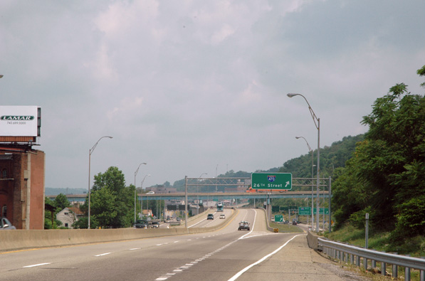
After passing through Strasburg, US 250 enters Interstate 77. The two routes then travel south overlapped with one another.
New Philadelphia to Cadiz
Interstate 77 and US 250 travel in a southern direction until reaching New Philadelphia. The two highways form a bypass of the city, with the concurrency forming the west side and US 250 along forming the south side, as Interstate 77 separates from US 250 in the southeast corner of the city. OH 800 joins the freeway at Broadway outside of New Philadelphia as it follows the Dennison/Uhrichsville freeway bypass of US 250. The two routes follow a four-lane, divided highway toward Uhrichsville, where US 250/SR 800 turns west at an interchange. At the end of the dual highway, SR 800 turns south toward Dennison, and US 250 turns north, following a two-lane, curvy alignment en route to Cadiz.
Approximately half-way between Dennison and Cadiz, US 250 follows Tappan Lake for several miles on a series of causeways built during the construction of the lake by the Muskingum Watershed Conservancy District in the 1930s. This route is generally of good quality (albeit without shoulders), although ODOT is studying replacement or upgrade through its Macro-Corridors Project.[2] Near Cadiz, it merges onto the Cadiz Bypass, where it runs concurrent with US 22. It then turns onto Lincoln Avenue and passes through the city of Cadiz. US 250 then turns onto Market Street and follows it south out of town.
Cadiz to Bridgeport
From Cadiz, US 250's name changes to Cadiz–Harrisville Road, heading south-southeast. Shortly after exiting the city, US 250 begins to curve and wind sharply, with several hairpin turns. For much of this distance, the road is surrounded by dense residential areas and runs on ridge tops. After it passes through Harrisville, the road becomes less curvy but is fronted densely with homes for almost the remainder of its route within the state, save the forest at its south end, where it features another hairpin curve. It continues southeast to Bridgeport, where it features a partial interchange with OH 7. US 250 then joins US 40 and crosses the Ohio River into West Virginia.
The poor alignment of this section of the highway, along with the fact that it runs through Cadiz as opposed to bypassing it, limits the usefulness of this section of the road as a through route. To resolve these issues, the Ohio Department of Transportation is developing plans to construct a Super 2 replacement for this route. A bypass of Cadiz was planned for construction in 2004,[3] although it has not been built as of 2008. The new route is to roughly parallel OH 9 and OH 331, running from Cadiz to a point near Saint Clairsville. At this point, it is expected that US 250 will be realigned to follow I-70 east to Wheeling, West Virginia.
West Virginia

U.S. 250's northern entrance into West Virginia is via the Military Order of the Purple Heart Bridge from Bridgeport, Ohio onto Wheeling Island. It is briefly co-signed with U.S. Route 40. The route additionally co-signs with Interstate 70 and crosses the Ohio River on the Fort Henry Bridge in Wheeling, West Virginia. U.S. Route 250 then exits I-70 east of the Wheeling Tunnel and joins West Virginia Route 2 one mile (1.6 km) later. In Moundsville, West Virginia, the route leaves WV 2 and departs toward Cameron, Mannington, and Fairmont. It finally intersects with its parent route, U.S. Route 50, in Grafton and continues southward. The route moves through Philippi, and finally through Elkins. U.S. Route 250 intersects with U.S. Route 33 and U.S. Route 219 briefly in Elkins, which is the last major hub before U.S. Route 250 winds its way through the Appalachian Mountains to the Virginia border.
U.S. 250 in West Virginia includes the Philippi Covered Bridge at Philippi, the only covered bridge on the United States Numbered Highway System.
Virginia
Main article: U.S. Route 250 in VirginiaUS 250 runs 166.74 miles (268.34 km) from the West Virginia state line near Hightown east to its eastern terminus at US 360 in Richmond. US 250 is the main east–west highway of Highland County, which is known as Virginia's Little Switzerland; the highway follows the path of the 19th century Staunton and Parkersburg Turnpike. From Staunton east to Richmond, the U.S. Highway serves as the local complement to Interstate 64 (I-64), roughly following the 18th century Three Notch'd Road through Waynesboro and Charlottesville on its way through the Shenandoah Valley, its crossing of the Blue Ridge Mountains at Rockfish Gap, and the Piedmont. In the Richmond metropolitan area, US 250 is known as Broad Street, a major thoroughfare through the city's West End and downtown areas.
History
Earlier roads, funding conflicts
Between Short Pump and Staunton, U.S. 250 largely follows the routing of the Three Notch'd Road (or the Three Chopt Road),[4] which had been established in the Colony of Virginia between Richmond and the Shenandoah Valley by the 1740s.[5] Most likely, the road followed an ancient Monacan trail from Orapax (east of Richmond) to the western Shenandoah Valley. This well-planned route required only one major river crossing, the Rivanna at Charlottesville, with inns or taverns spaced about 10 miles (16 km) apart.
The route west of Staunton was built about 100 years later as a toll road, the Staunton-Parkersburg Turnpike. In the second quarter of the 19th century, it became a major gateway into Virginia's "Trans-Allegheny" region, which presented much greater challenges to transportation than did less rugged portions of the state. In that region, navigable waterways were unavailable and canals impractical. Wheeled vehicles in the form of wagons, and later, motor vehicles needed to pass through with passengers and freight. It became part of the main trade route for salt and other commodities in the early 19th century. As the American Civil War broke out, the route became very important and was defended by Stonewall Jackson's troops at the Battle of McDowell in 1862.
The portion of the Staunton-Parkersburg Turnpike west of Allegheny Mountain (almost all of it) became part of West Virginia in 1863. Virginia's pre-War debt became a major issue after the American Civil War, as millions of dollars of debt remained for infrastructure improvements, some of which were now located in the new state of West Virginia, including most of the Staunton-Parkersburg Turnpike. Political divisions in Virginia on this issue resulted in creation of a new major political group in the late 1870s, the Readjuster Party, a coalition of Democrats, Republicans, and African-Americans seeking a reduction in Virginia's prewar debt by allocating an appropriate portion to the new State of West Virginia.
For several decades, Virginia and West Virginia disputed the new state's share of the Virginia government's debt. The issue was finally settled in 1915, when the United States Supreme Court ruled that West Virginia owed Virginia $12,393,929.50. The final installment of this sum was paid off in 1939.[6]
U.S. Highway system, numbering
U.S. Route 250 was created in 1928 and was originally routed from U.S. Route 50 in Grafton, West Virginia north/west to Norwalk, Ohio. In 1932, the route was expanded west to Sandusky, Ohio. In 1934, the route was expanded southward and eastward to Richmond, Virginia.[7]
References
- ^ ODOT TRAC Tier III Project Listing, 1997.
- ^ Morrison, Lee (2008-01-26). "Highway project study to move forward". Times-Reporter, The. http://www.timesreporter.com/index.php?ID=78618. Retrieved 2008-04-13.
- ^ Ohio Department of Transportation New Tier I projects, accessed April 13, 2008.[dead link]
- ^ http://www.virginiadot.org/VTRC/main/online_reports/pdf/76-r32.pdf
- ^ http://www.historicwoolenmills.org/chronology.html
- ^ http://www.wvculture.org/HISTORY/government/vawvdebt03.html
- ^ east–west Routes - US 2 to US 98 (& US 400) - Even numbered US highways
Browse numbered routes ←  WV 230
list WV 251  →Categories:
- Three-digit U.S. Highways
- U.S. Highways in West Virginia
- U.S. Highways in Ohio
- U.S. Route 50


Wikimedia Foundation. 2010.