- U.S. Route 550
-
U.S. Route 550
Million Dollar Highway 
Route information Auxiliary route of US 50 Length: 305 mi (491 km) Existed: 1926 – present Major junctions South end: 
 I-25 / NM 165 in Bernalillo, NM
 US 64 in Bloomfield, NM
 US 160 in Durango, CO
North end:  US 50 at Montrose, CO
Highway system United States Numbered Highways
List • Bannered • Divided • Replaced←  NM 549
NM NM 551  →
→←  US 491
CO US 650  →
→U.S. Route 550 is a spur of U.S. Highway 50 that runs from Bernalillo, New Mexico to Montrose, Colorado in the western United States. The section from Silverton to Ouray is frequently called the Million Dollar Highway.[1]
Contents
Route description
New Mexico
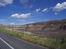 View of volcanic structures at southbound Mile Marker 111 in New Mexico (36.2558°N 107.6229°W).
U.S. 550 begins just north of Albuquerque at Bernalillo and passes through the towns of San Ysidro, Cuba, Bloomfield and Aztec. All of Highway 550 in New Mexico has been upgraded to four lanes, offering a high-speed (70 mph) connection for Farmington, New Mexico and Durango, Colorado to Albuquerque and Santa Fe.
Colorado
 View of Twilight Peak from US 550.
Most of U.S. 550 in Colorado is two-lane mountainous highway. It is one of only two north–south U.S. Highways in Colorado which runs west of the Continental Divide The other route is US 491. The route travels north through the San Juan Mountains.
The Million Dollar Highway stretches for about 25 miles (40 km) in western Colorado and follows the route of U.S. 550 between Silverton and Ouray, Colorado. It is part of the San Juan Skyway Scenic Byway. Between Durango and Silverton the Skyway loosely parallels the Durango and Silverton Narrow Gauge Railroad.
 U.S. Route 550 at the Uncompahgre Gorge
Though the entire stretch has been called the Million Dollar Highway, it is really the twelve miles (19 km) south of Ouray through the Uncompahgre Gorge to the summit of Red Mountain Pass which gains the highway its name. This stretch through the gorge is challenging and potentially hazardous to drive; it is characterized by steep cliffs, narrow lanes, and a lack of guardrails; the ascent of Red Mountain Pass is marked with a number of hairpin "S" curves used to gain elevation, and again, narrow lanes for traffic—many cut directly into the sides of mountains. During this ascent, the remains of the Idarado Mine are visible. Travel north from Silverton to Ouray allows drivers to hug the inside of curves; travel south from Ouray to Silverton perches drivers on the vertiginous outside edge of the highway. Large RVs travel in both directions, which adds a degree of excitement (or danger) to people in cars.[2] The road is kept open year-round. Summer temperatures can range from 70-90 degree highs at the ends of the highway to 50-70 degrees in the mountain passes. The snow season starts in October, and snow will often close the road in winter. Chains may be required to drive.[3]
North of Durango, the highway passes by Trimble Springs, hot springs that have been open for visitors since the late 19th century. The highway runs north along the Animas River, under the Hermosa Cliffs. It enters the San Juan National Forest and goes past Haviland Lake and Elektra Lake. Drivers pass by Engineer Mountain and Twilight Peak before crossing Coal Bank Pass. Next is Molas Pass, which offers a panoramic view of Molas Lake, the Animas River Gorge, and Snowdon Peak. Northbound travelers then pass through the town of Silverton, elevation 9,320 feet (2841 m), surrounded by 13,000 foot (4000 m) peaks Sultan Mountain, Kendall Mountain, and Storm Peak.[3]
The highway leaves Silverton and proceeds up Mineral Creek Valley before ascending to Red Mountain Pass. The ruins of the Longfellow Mine are visible along the way. The highway then goes through a series of steep grades and hairpin turns before reaching Lookout Point, which offers a view of the town of Ouray.[3]
 Looking south toward Red Mountain Pass.
This section of the route passes over three mountain passes:
- Coal Bank Pass, elevation 10,640 ft (3,240 m).
- Molas Pass, elevation 10,970 ft (3,340 m).
- Red Mountain Pass, elevation 11,018 ft (3,358 m).
The origin of the name Million Dollar Highway is disputed. There are several legends, though, including that it cost a million dollars a mile to build in the 1920s, and that its fill dirt contains a million dollars in gold ore.[1]
U.S. 550 ends at the corner of Townsend Avenue and San Juan Avenue in Montrose, Colorado at the junction of its parent route U.S. Highway 50.
History
 A view of the Million Dollar Highway pass.
The original portion of the Million Dollar Highway was a toll road built by Otto Mears in 1883 to connect Ouray and Ironton.[1] Another toll road was built over Red Mountain Pass from Ironton to Silverton. In the late 1880's Otto Mears turned to building railroads and built the Silverton Railroad north from Silverton over Red Mountain Pass to reach the lucrative mining districts around Red Mountain, terminating at Albany just eight miles (13 km) south of Ouray. The remaining eight miles (13 km) were considered too difficult and steep for a railroad. At one point a cog railroad was proposed, but it never made it beyond the planning stage.
In the early 1920's, the original toll road was rebuilt at considerable cost and became the present day US 550. The Million Dollar Highway was completed in 1924.[3] Today the entire route is part of the San Juan Skyway Scenic Byway.
Highway 550 was part of the original 1926 federal highway system. The original highway extended 110 miles (177 km) from Montrose, Colorado at U.S. Highway 50 to U.S. Highway 450 (now U.S. Highway 160) at Durango, Colorado. In 1934, Highway 550 was extended through Farmington to Shiprock, New Mexico. In 1989, the western end of Highway 550 was replaced with U.S. Highway 64 between Farmington and Shiprock. In 1999, Highway 550 was rerouted at Aztec, New Mexico to replace New Mexico State Highway 44 to Bernalillo, New Mexico, at which time all of Highway 550 in New Mexico was upgraded to four lanes.
In 2009 U.S. 50 was re-routed onto the San Juan Avenue bypass to avoid downtown Montrose. As a result, U.S. 550 was extended approximately one mile Northwest to intersect with the new U.S. 50 alignment.
Major intersections
County Location Mile[4] Destinations Notes Sandoval Bernalillo 0.000 I-25 south – Albuquerque0.000 I-25 north – Santa Fe2  NM 528 south – Rio Rancho
23.5  NM 4 north – San Ysidro
41.5  NM 279 west
63  NM 197 south – Torreon
Cuba 64.5  NM 126 east- Santa Fe National Forest
67  NM 96 north – La Jara
85  NM 537 north
San Juan 123  NM 57 south
Bloomfield 151 US 64 – Farmington, TaosSouthern end of NM 544 overlap Aztec 160  NM 516 west (Aztec Boulevard) – Farmington
161  NM 173 east- Navajo State Park
175
0.000Colorado-New Mexico state line La Plata 191 US 160 east – Pagosa SpringsSouth end of US 160 overlap Durango 195  SH 3 north
195.5 US 160 west – CortezNorth end of US 160 overlap Ouray Ridgway 277  SH 62 west – Placerville
Montrose Montrose 303  SH 90 west (Main Street) – Naturita
305 US 50 – Delta, GunnisonSee also
Related routes
- U.S. Route 50
- U.S. Route 150
- U.S. Route 250
- U.S. Route 350
- U.S. Route 450
- U.S. Route 650
References
- ^ a b c Road Trip America - Million Dollar Highway by Mark Sedenquist accessed OCT-21-2007
- ^ The Cultured Traveler-Million Dollary Highway by "Totty" accessed OCT-21-2007
- ^ a b c d Million Dollar Highway
- ^ Colorado Department of Transportation, Highway Data, accessed October 2007: note that not every interval between mileposts is exactly a mile, explaining why more exits than expected are at the exact milepost
Towns National Forests Other Categories:- Three-digit U.S. Highways
- U.S. Highways in Colorado
- U.S. Highways in Ouray County, Colorado
- U.S. Route 50
- Montrose, Colorado
- Transportation in Sandoval County, New Mexico
- Transportation in San Juan County, New Mexico


Wikimedia Foundation. 2010.