- Massachusetts Route 133
-
Route 133
Route information Length: 40.87 mi[2] (65.77 km) Existed: 1930[1] – present Major junctions West end: 
 Routes 38/110 in Lowell
 I-495 in Tewksbury
 I-93 in Andover
 Route 114 in North Andover
 I-95 in Georgetown
 US 1 in Rowley
 Route 128 in Gloucester
East end:  Route 127 in Gloucester
Highway system Massachusetts State Highway Routes
←  Route 132
Route 134  →
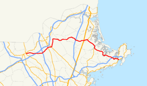
→Route 133 is an east–west Massachusetts state route that runs from Lowell to Gloucester.
Route description
Route 133 begins at the junction of Route 38 and Route 110 in Lowell, where Route 110 begins a concurrency with Route 38 northbound. Route 133 heads east from this point, heading through the northern end of Tewksbury, where it has a junction with I-495 at Exit 39. Shortly after crossing the highway, Route 133 enters Essex County and the town of Andover. In Andover, Route 133 crosses I-93 at Exit 43 and continues eastward, bypassing the town center to the north as it crosses Route 28.
From there, Route 133 continues eastward into the town of North Andover. In North Andover, Route 133 crosses Route 114 (the Salem Turnpike) just north of Merrimack College. It then joins Route 125 for a concurrency that lasts for 2.7 miles (4.3 km). The two routes split next to Lawrence Municipal Airport, with Route 133 passing the northern banks of Lake Cochichewick before entering Boxford. The route passes through the village of West Boxford before continuing into Georgetown.
In Georgetown, Route 133 passes south of the Lufkins Brook Area before meeting Route 97 for a short concurrency that lasts for a tenth of a mile. The two routes split at the center of town, with Route 97 heading northwest on West Main Street and Route 133 heading southeast on East Main Street. As it passes the Georgetown-Rowley State Forest, Route 133 crosses I-95 at Exit 54 just before entering the town of Rowley. In Rowley, Route 133 crosses U.S. Route 1 (the Newburyport Turnpike) at Kent Corner, before it meets Route 1A. Route 133 then begins a concurrency with Route 1A heading southbound into Ipswich.
In Ipswich, the two routes cross the Newburyport Line railroad tracks as it enters the downtown area. The two routes cross the historic Choate Bridge over the Ipswich River concurrently, before turning southward, passing through the historic village before splitting once more, with Route 133 heading east-southeastward into Essex. Route 133 passes the northern end of Route 22 near the crossing of the Essex River before Route 133 heads into Gloucester. In Gloucester, Route 133 crosses Route 128 at exit 14 before crossing the Little River (an offshoot of the Annisquam River) and passing the West Gloucester MBTA station. Route 133 finally ends at Route 127, just west of the bridge over the Blynman Canal.
In 1930, Route 133 extended from Lowell to Rowley, ending at Route 1A. Between 1959 and 1961, it was extended to Gloucester via Ipswich and Essex.[1]
Junction list


Eastbound in Georgetown Center County Location Mile Roads intersected Notes Middlesex Lowell 0.00 Route 38
Route 110Western end of Route 133 at intersection of Routes 38 and 110. Tewksbury 3.4 I-495I-495 Exit 39. Essex Andover 5.8 I-93I-93 Exit 43; signed as Exit 43A-B on I-93 Southbound. 8.4  Route 28
North Andover 9.6 Route 1149.8  Route 125 South
Southern end of concurrency with Route 125. 12.6 Route 125 NorthNorthern end of concurrency with Route 125. Georgetown 19.5  Route 97 South
Southern end of concurrency with Route 97. 19.6 Route 97 NorthNorthern end of concurrency with Route 97. 21.5 I-95I-95 Exit 54; signed as Exit 54A-B on I-95 northbound. Rowley 24.5 U.S. Route 1Kent Corner. 26.1  Rotue 1A North
Northern end of concurrency with Route 1A. Ipswich 30.0 Rotue 1A SouthSouthern end of concurrency with Route 1A. Essex 34.5  Route 22 South
Northern end of Route 22. Gloucester 38.0 Route 128Route 128 Exit 14. 40.87 Route 127Eastern end of Route 133. References
- ^ a b Kelley, Neil. "MA 133" (route log entry). Massachusetts Route Log. neilbert.com. http://www.neilbert.com/findroute.php?route=133. Retrieved 2006-12-28.
- ^ Executive Office of Transportation, Office of Transportation Planning - 2007 Road Inventory
- Moraseski, Dan. "MA routes 130-139". MA route log. web.mit.edu. Archived from the original on 2004-10-25. http://web.archive.org/web/20041025164723/http://web.mit.edu/spui/www/boston/sr/13x.html#133. Retrieved 2006-07-13. (Wayback Machine archive, original site down)
Categories:- Numbered routes in Massachusetts


Wikimedia Foundation. 2010.