- Northmead, New South Wales
-
Northmead
Sydney, New South Wales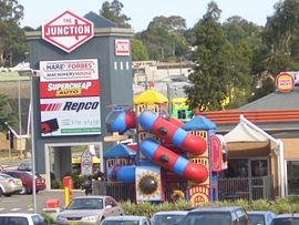
The Junction, Windsor RoadPostcode: 2152 Location: 26 km (16 mi) west of Sydney CBD LGA: City of Parramatta, The Hills Shire State District: Baulkham Hills, Parramatta Federal Division: Mitchell, Parramatta Suburbs around Northmead: Winston Hills Baulkham Hills North Rocks Old Toongabbie Northmead North Parramatta Wentworthville Westmead Parramatta  Northmead shopping centre
Northmead is a suburb of Sydney, in the state of New South Wales, Australia. Northmead is located 26 kilometres west of the Sydney central business district, in the local government areas of the City of Parramatta and The Hills Shire. Northmead is part of the Greater Western Sydney region.
Northmead is a hilly suburb with low to medium density houses, townhouses and apartment buildings, and a large light industrial area. It is located to the northeast of the junction of Darling Mills Creek and Toongabbie Creek, which combine to form the beginnings of the Parramatta River.
Contents
History
With the British settlement of Parramatta, this area was originally part of the domain of Government House. What is left of this domain, including Government House, forms Parramatta Park. The name Northmead is derived from the location of the north "mead", or meadow, of the governor's domain.[1] The land was subdivided between 1859 and 1889 and the Northern Meadow and Western Meadow of the domain were split off and called Northmead and Westmead. From this time, orchards were established by many new settlers, including some whose names were well-known in the Parramatta area - George Oakes, Nat Payten and William Fullagar among them.
Commercial Areas
Commercial Area 1
Northmead Shopping Centre is located at 2 Campbell St, corner of Windsor Road, and features an IGA supermarket and many specialty shops. Specialty shops include pizza takeaway, medical centre, pet store, beautician, deli, butcher, bakery, dry cleaners, chemist, fruit & veg, and a Chinese restaurant. The centre is managed by PRD Nationwide in Bondi Junction.
Commercial Area 2
The Junction shops are located on the corner of Windsor Road and Briens Road and features a number of retailers for home furnishings, hardware, car accessories (Supercheap Auto, Repco), electricals like Dick Smith Electronics and food outlets Subway, Hungry Jacks, Winning Appliances and Hog's Breath.
Industrial Area
Northmead is the home of a large number of light industires, especially around Briens Road which runs along the back of the Westmead Hospital district. Along Briens Road are:
- Coca-Cola Amatil bottles Coca-Cola and other softdrink
- Australian Paper
- Ontera Carpets
Schools
- Northmead Public School - Moxhams Road.
- Northmead High School - Campbell Street.
Transport
The North West T-Way connecting the Hills with Parramatta runs through Northmead. Northmead's public transport needs are only catered by busses, namely those of the Hillsbus bus company. This results in overcrowded and overused bus services in the Hills District - an area that is one of the fastest growing in Australia.
The major roads are Windsor Road and the Cumberland Highway.
Transport History
Before it was decommissioned in 1932 as a cost saving measure by a state Labor Government, Northmead featured a train line known as the Rogans Hill railway line. Currently, there is no train line that services Northmead with the closest being the Main Western Railway Line that runs through Westmead and Parramatta.
Notable residents
- Current Liberal Parramatta City Councilor, Scott Lloyd was raised in Northmead, and went to Northmead primary school between 1983 and 1989.
References
- ^ "History of Northmead". hillsdirectory.com.au. http://hillsdirectory.com.au/Hills-Information/History-of-Suburbs/Northmead. Retrieved 11 February 2010.
External links
- Northmead, New South Wales is at coordinates 33°46′54″S 151°00′08″E / 33.78166°S 151.00209°ECoordinates: 33°46′54″S 151°00′08″E / 33.78166°S 151.00209°E
Suburbs and localities within the City of Parramatta · Western Sydney · Sydney Camellia · Carlingford · Chester Hill · Clyde · Constitution Hill · Dundas · Dundas Valley · Eastwood · Epping · Ermington · Granville · Harris Park · Model Farms · Northmead · Oatlands · Old Toongabbie · Parramatta · North Parramatta · Pendle Hill · Rosehill · Rydalmere · South Granville · Telopea · Toongabbie · Winston Hills · Wentworthville · Westmead
Categories:- Suburbs of Sydney


Wikimedia Foundation. 2010.