- New York State Route 56
-
This article is about the current alignment of NY 56. For the former alignment of NY 56 in eastern St. Lawrence and Franklin Counties, see New York State Route 56 (1920s–1930).
NYS Route 56
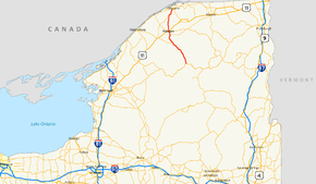
Map of northern New York with NY 56 highlighted in redRoute information Maintained by NYSDOT Length: 51.47 mi[2] (82.83 km) Existed: 1930[1] – present Major junctions South end:  NY 3 in Colton
 US 11 in Potsdam
North end:  NY 37 near Massena
Location Counties: St. Lawrence Highway system Numbered highways in New York
Interstate • U.S. • N.Y. (former) • Reference • County←  NY 55A
NY 56A  →
→New York State Route 56 (NY 56) is a north–south state highway in eastern St. Lawrence County, New York, United States. The southern terminus of the route is at an intersection with NY 3 in the town of Colton. Its northern terminus is at a junction with NY 37 southwest of Massena in the town of Louisville. NY 56 follows the Raquette River for most of its length and serves the village of Potsdam, where it passes by the campus of Clarkson University.
Contents
History
NY 56 was assigned as part of the 1930 renumbering of state highways in New York to an alignment extending from NY 3 in the town of Colton to NY 420 south of Massena.[1] In the vicinity of Massena, NY 56 was originally routed on West Hatfield Road.[3] NY 56 was realigned ca. 1937 to follow a new highway into Massena, where it ended at a junction with NY 420 (Main Street) just south of where NY 420 ended at NY 37.[4][5]
In the mid-1950s, construction began on a new alignment for NY 37 around the southern edge of Massena.[6][7] The highway opened to traffic by 1958;[8] however, NY 56 continued to extend past the bypass into Massena until the early 1960s, when it was cut back to its junction with NY 37's new routing.[9] The former routing of NY 56 in Massena is still state-maintained as NY 970C, an unsigned reference route designation for Andrews Street between NY 37 and Main Street (itself unsigned NY 970B).[10]
NY 56A

NY 56A was an alternate route of NY 56 between Potsdam and Norfolk in St. Lawrence County. The route began in Potsdam, headed northwest to Madrid, then turned northeast and continued to its northern terminus in Norfolk. NY 56A was assigned in 1930[1] and removed in 1980.[10]
Major intersections
The entire route is in St. Lawrence County.
Location Mile[2] Destinations Notes Colton 0.00 NY 3Hamlet of Sevey Corners 22.96  NY 68
NY 68Eastern terminus of NY 68 Town of Potsdam 30.82  NY 72
NY 72Western terminus of NY 72 Village of Potsdam 32.78 US 11 northSouthern terminus of US 11 / NY 56 overlap 32.95 US 11 southNorthern terminus of US 11 / NY 56 overlap Town of Norfolk 41.80  CR 38
CR 38Former eastern terminus of NY 56A 45.29  NY 310
Northern terminus of NY 310 Louisville 51.47 NY 371.000 mi = 1.609 km; 1.000 km = 0.621 mi References
- ^ a b c Dickinson, Leon A. (January 12, 1930). "New Signs for State Highways". The New York Times: p. 136.
- ^ a b "2008 Traffic Volume Report for New York State" (PDF). New York State Department of Transportation. June 16, 2009. p. 120. https://www.nysdot.gov/divisions/engineering/technical-services/hds-respository/NYSDOT%20TVR%202008%20by%20Route.pdf. Retrieved January 31, 2010.
- ^ Standard Oil Company of New York (1930). Road Map of New York (Map). Cartography by General Drafting.
- ^ Standard Oil Company (1936). New York (Map). Cartography by General Drafting.
- ^ Standard Oil Company (1937). New York (Map). Cartography by General Drafting.
- ^ Esso (1954). New York with Special Maps of Putnam–Rockland–Westchester Counties and Finger Lakes Region (Map). Cartography by General Drafting (1955–56 ed.).
- ^ Esso (1956). New York with Special Maps of Putnam–Rockland–Westchester Counties and Finger Lakes Region (Map). Cartography by General Drafting (1957 ed.).
- ^ Esso (1958). New York with Special Maps of Putnam–Rockland–Westchester Counties and Finger Lakes Region (Map). Cartography by General Drafting (1958 ed.).
- ^ Sunoco (1961). New York and Metropolitan New York (Map). Cartography by H.M. Gousha Company (1961–62 ed.).
- ^ a b New York State Department of Transportation (January 2009) (PDF). Official Description of Highway Touring Routes, Bicycling Touring Routes, Scenic Byways, & Commemorative/Memorial Designations in New York State. https://www.nysdot.gov/divisions/operating/oom/transportation-systems/repository/2009%20tour-bk.pdf. Retrieved June 3, 2009.
External links
Categories:- State highways in New York
- Transportation in St. Lawrence County, New York


Wikimedia Foundation. 2010.