- Cuckfield
-
Coordinates: 51°00′20″N 0°08′26″W / 51.0055°N 0.1406°W
Cuckfield 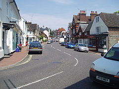
Cuckfield High Street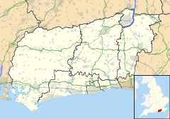
 Cuckfield
Cuckfield shown within West SussexArea 4.32 km2 (1.67 sq mi) [1] Population 3,266 [1] 2001 Census - Density 757 /km2 (1,960 /sq mi) OS grid reference TQ305245 - London 34 miles (55 km) N Parish Cuckfield District Mid Sussex Shire county West Sussex Region South East Country England Sovereign state United Kingdom Post town Haywards Heath Postcode district RH17 Dialling code 01444 Police Sussex Fire West Sussex Ambulance South East Coast EU Parliament South East England UK Parliament Mid Sussex List of places: UK • England • West Sussex Cuckfield is a large village and civil parish in the Mid Sussex District of West Sussex, England, on the southern slopes of the Weald. It lies 34 miles (55 km) south of London, 13 miles (21 km) north of Brighton, and 31 miles (50 km) east northeast of the county town of Chichester. Nearby towns include Haywards Heath to the southeast and Burgess Hill to the south. It is surrounded on some sides by Cuckfield Rural.
Before the modern local government system came in to operation in the late 19th century it was described as being in the hundred of Buttinghill, in the rape of Lewes. The civil parish covers an area of 431.58 ha (1066 acres), and had a population of 3,266 persons in the 2001 census.
The origin of the name, Cuckfield (earlier spelled Kukefeld, Cucufeld, and Cucufelda), is debated but it is generally associated with the cuckoo which is the village emblem. The name is pronounced with a long 'u' sound, and does not rhyme with the nearby town of Uckfield which is pronounced with a short 'u' sound).
The village grew as a market town; and an important coaching stop between London and Brighton, since it lay on the turnpike. In 1820, 50 coaches a day were passing through; but when the railway to Brighton was to be constructed in the 1840s, local landowners objected to its projected route: it was therefore built through neighbouring Haywards Heath instead. The village lost its importance as a result. Today the A272 road also bypasses the village centre. It is however home to Warden Park Specialist School one of the main secondary schools serving the Haywards Heath area.
It became an urban district in 1894 under the Local Government Act 1894, and was greatly enlarged in 1934 under a County Review Order by adding part of Chailey Rural District, Cuckfield Rural District (including the parish of Lindfield) and Haywards Heath Urban District.
The Parish Council, Cuckfield Museum and village library reside within the Queen's Hall, built in 1897 to celebrate Queen Victoria's Diamond Jubilee. The parish church, dedicated to the Holy Trinity, has Norman foundations, although the building itself is 13th century. The lych gates are listed buildings and several of the stained glass windows as well as the pulpit and the ceiling's painting were designed by Charles Eamer Kempe (1837–1907).
Gideon Mantell found the first known iguanodon fossils close to Cuckfield at Whitemans Green, where a monument to him now stands. He also features in the town's museum. Other attractions include the Elizabethan stately home, Cuckfield Park, to the west of the village. The Cuckfield Bonfire Night celebrations are held here. Another Elizabethan house, Ockenden Manor, is a restaurant which has had one star from the Michelin Guide since 2001.
Cuckfield is also known locally for its idiosyncratic system of mayoral voting; unlimited numbers of votes can be purchased for the price of one penny each, with the winner receiving the most votes.[1] The position is purely honorary and the money raised supports local charities.
Notable people
- Tommy Cook (1901–50) - Sussex cricketeer and Brighton & Hove Albion and England footballer.
- Jeremy Cunningham - Bass player in British band the Levellers.
- Hermione Cockburn - Geologist and broadcaster, was brought up in the village.
- The brothers Edward Fox, James Fox (both actors) and Robert Fox (a producer) all grew up in the village. Their mother died there in 1999.
- Sally Geeson - Actress, best remembered for her role in the British sitcom Bless This House with Sid James was born in the village.
- Thomas Vicars (1589-1638) - 17th-century theologian
- James Vince (1991-) - Hampshire cricketer
- Nick Van Eede (1958-) - Lead vocalist and co-founder of the British-based band Cutting Crew
References
- ^ a b "2001 Census: West Sussex – Population by Parish". West Sussex County Council. http://www.westsussex.gov.uk/communityandliving/census2001/pop_parish_summary.pdf. Retrieved 7 April 2009.
External links
- Cuckfield Town Website
- Cuckfield Parish Council
- Cuckfield European Association - A non political organisation that promotes twinning links with towns in France and Germany and organises a wide range of social events and trips throughout the year.
- Holy Trinity, Cuckfield (Anglican Parish Church)
- Independent State of Cuckfield - The community charity responsible for the idiosyncratic system of voting for mayor.
- Cuckfield Compendium - a large collection of information on Cuckfield.
- Cuckfield Bonfire Website
Towns Villages and hamlets Albourne · Ansty · Ardingly · Ashurst Wood · Balcombe · Bolney · Clayton · Copthorne · Crawley Down · Cuckfield · Fulking · Goddards Green · Handcross · Hassocks · Hickstead · Horsted Keynes · Hurst Wickham · Hurstpierpoint · Keymer · Lindfield · Newtimber · Pease Pottage · Poynings · Pyecombe · Saddlescombe · Sayers Common · Scaynes Hill · Sharpthorne · Slaugham · Staplefield · Turners Hill · Twineham · Walstead · Warninglid · West HoathlyCivil parishes Categories:- Mid Sussex
- Villages in West Sussex


Wikimedia Foundation. 2010.