- Porlock
-
For other uses, see Porlock (disambiguation).
Coordinates: 51°12′32″N 3°35′44″W / 51.208796°N 3.595557°W
Porlock 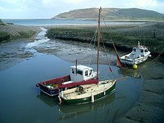
Porlock Weir
 Porlock
Porlock shown within SomersetPopulation 1,377 [1] OS grid reference SS886467 District West Somerset Shire county Somerset Region South West Country England Sovereign state United Kingdom Post town MINEHEAD Postcode district TA24 Dialling code 01643 Police Avon and Somerset Fire Devon and Somerset Ambulance South Western EU Parliament South West England UK Parliament Bridgwater and West Somerset List of places: UK • England • Somerset Porlock is a coastal village and civil parish in Somerset, England, situated in a deep hollow below Exmoor, 5 miles (8.0 km) west of Minehead. The parish, which includes Hawkcombe and Doverhay, has a population of 1,377.[1]
In a 2010 survey based on data from the Office of National Statistics Porlock was found to have the most elderly population in Britain with over 40% of the population being of pensionable age.[2]
Contents
History
East of the village is Bury Castle, an Iron age hill fort.
In the Domesday book the village was known as "Portloc".[3]
Porlock was part of the hundred of Carhampton.[4]
The area has links with several Romantic poets, and R. D. Blackmore the author of Lorna Doone, and is popular with visitors. The visitor centre with exhibits and displays about the local area. Also on display are the bones of an Aurochs, discovered on Porlock beach in 1999.[5]
Governance
The parish council has responsibility for local issues, including setting an annual precept (local rate) to cover the council’s operating costs and producing annual accounts for public scrutiny. The parish council evaluates local planning applications and works with the local police, district council officers, and neighbourhood watch groups on matters of crime, security, and traffic. The parish council's role also includes initiating projects for the maintenance and repair of parish facilities, as well as consulting with the district council on the maintenance, repair, and improvement of highways, drainage, footpaths, public transport, and street cleaning. Conservation matters (including trees and listed buildings) and environmental issues are also the responsibility of the council.
The village falls within the Non-metropolitan district of West Somerset, which was formed on 1 April 1974 under the Local Government Act 1972, having previously been part of Williton Rural District.[6] The district council is responsible for local planning and building control, local roads, council housing, environmental health, markets and fairs, refuse collection and recycling, cemeteries and crematoria, leisure services, parks, and tourism.
Somerset County Council is responsible for running the largest and most expensive local services such as education, social services, libraries, main roads, public transport, policing and fire services, trading standards, waste disposal and strategic planning.
As Porlock falls within the Exmoor National Park some functions normally administered by district or county councils have, since 1997, fallen under the Exmoor National Park Authority, which is known as a ‘single purpose’ authority, which aims to "conserve and enhance the natural beauty, wildlife and cultural heritage of the National Parks" and "promote opportunities for the understanding and enjoyment of the special qualities of the Parks by the public",[7] including responsibility for the conservation of the historic environment.[8]
It is also part of the Bridgwater and West Somerset county constituency represented in the House of Commons of the Parliament of the United Kingdom. It elects one Member of Parliament (MP) by the first past the post system of election, and part of the South West England constituency of the European Parliament which elects seven MEPs using the d'Hondt method of party-list proportional representation.
Geography
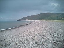 Porlock beach
The village adjoins a Porlock Ridge and Saltmarsh nature reserve created when the lowland behind a high shingle embankment was breached by the sea in the 1990s, which has now been designated as a Site of Special Scientific Interest. Copses of white dead trees remind the visitor of when this was fresh water pasture.
A wooded combe called Hawkcombe leads about three miles (5 km) from the village up to high open moorland. The stream, (which is called "Hawkcombe Waters"), runs past a Victorian hunting lodge, called The Cleeve, then underground beneath the Overstream Hotel in the centre of the village.
The South West Coast Path goes through Porlock, many walkers stopping rather than continuing on the gargantuan walk to Lynton. There is also a 'Coleridge Way' walk.
Culbone church is said to be the smallest church in England.[9] The main structure is 12th century. Services are still held there, despite the lack of road access — it is a two-mile (3 km) walk from Porlock Weir, and some 3-4 miles (6.4 km) from Porlock itself.
A new toll road bypasses the 1-in-4 gradient on Porlock Hill. There is an ancient stone circle on the hill.
Submerged forest
 A map of Porlock from 1937
At low tide the remains of a submerged forest can be seen on Porlock Beach. The area was several miles inland until the sea level in the Bristol Channel rose about 7,000 to 8,000 years ago.[10]
Church
The Church of St Dubricius dates from the 13th century. The spire was damaged in a storm of 1703.[3] The church has been designated by English Heritage as a grade I listed building.[11] Within the church is a 15th century tomb of John Harrington who fought alongside Henry V in France in 1417.[12]
Cultural references
"Person from Porlock"
Main article: Person from PorlockThe poet Samuel Taylor Coleridge, who lived nearby at Nether Stowey (between Bridgwater and Minehead), was interrupted during composition of his poem Kubla Khan by "a person on business from Porlock", and found afterward he could not remember what had come to him in a dream.
Coleridge and William Wordsworth (who lived nearby at Alfoxden) would often roam the hills and coast on long night walks, leading to local gossip that they were 'spies' for the French. The Government sent an agent to investigate, but found they were "mere poets". Their walks are celebrated by the Coleridge Way which ends in Porlock. Their friend Robert Southey published a poem titled "Porlock" in 1798.
William Blake
Legend has it that the area beyond Culbone towards Lynmouth where Glenthorne is now situated is where Jesus may have alighted on a trip with Joseph of Arimathea. This is said to have inspired a passage from William Blake's famous poem, Milton:
- "And did those feet in ancient time
- Walk upon England’s mountains green?
- And was the Holy Lamb of God
- On England’s pleasant pastures seen?
- And did the countenance divine
- Shine forth upon our clouded hills?
- And was Jerusalem builded here
- Among these dark satanic mills?"
References
- ^ a b "Parish Population Statistics". ONS Census 2001. Somerset County Council. http://www.webcitation.org/5lRyCc5hq. Retrieved 13 December 2009.
- ^ Ramesh, Randeep (26 May 2010). "People in rural areas live longer, says study". The Guardian. http://www.guardian.co.uk/uk/2010/may/25/rural-idyll-boots-life-expectancy. Retrieved 26 May 2010.
- ^ a b Farr, Grahame (1954). Somerset Harbours. London: Christopher Johnson. p. 154.
- ^ "Carhampton Hundred". Domesday Map. http://www.domesdaymap.co.uk/hundred/carhampton/. Retrieved 23 September 2011.
- ^ "Porlock Visitor Centre". Everything Exmor. http://www.everythingexmoor.org.uk/_P/Porlock_Visitor_Centre.php. Retrieved 20 February 2008.
- ^ A Vision of Britain Through Time : Williton Rural District
- ^ "The Authority". Exmoor National Park. http://www.exmoor-nationalpark.gov.uk/index/living_in/the_authority.htm. Retrieved 29 November 2007.
- ^ "Exmoor National Park NMP". English Heritage. http://www.english-heritage.org.uk/server/show/nav.00100200300400200300l. Retrieved 29 November 2007.
- ^ "Parish Churches". Somerset County archives. http://www.somerset.gov.uk/archives/ASH/Parishchs.htm. Retrieved 1 May 2011.
- ^ "Geological features". Exmoor National Park. http://www.exmoor-nationalpark.gov.uk/index/learning_about/looking_after_landscape/geology/geological_features.htm. Retrieved 21 March 2011.
- ^ "Church of St Dubricius". Images of England. http://www.imagesofengland.org.uk/details/default.aspx?id=265469. Retrieved 20 February 2008.
- ^ Leete-Hodge, Lornie (1985). Curiosities of Somerset. Bodmin: Bossiney Books. p. 45. ISBN 0906456983.
External links
- www.porlock.co.uk by the Porlock Tourist Association.
- www.porlock.org Porlock Vale Community Website.
Towns, villages and hamlets in the West Somerset district of Somerset, England  Allerford · Ashbeer · Bicknoller · Brandish Street · Brompton Ralph · Brompton Regis · Brushford · Carhampton · Clatworthy · Cockercombe · Crowcombe · Culbone · Cutcombe · Dulverton · Dunster · East Quantoxhead · Elworthy · Exford · Exton · Holford · Huish Champflower · Kilve · Lilstock · Luccombe · Luxborough · Minehead · Monksilver · Oare · Old Cleeve · Porlock · Roadwater · Sampford Brett · Selworthy · Simonsbath · Skilgate · Stogumber · Stogursey · Stringston · Timberscombe · Treborough · Upton · Washford · Watchet · West Quantoxhead · Williton · Winsford · Withycombe · Withypool · Wootton CourtenayCategories:
- Villages in West Somerset
- Exmoor
- Civil parishes in Somerset
- Populated coastal places in Somerset


Wikimedia Foundation. 2010.