- Mungrisdale
-
Coordinates: 54°39′47″N 2°59′20″W / 54.663°N 2.989°W
Mungrisdale 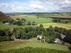
Mungrisdale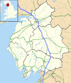
 Mungrisdale
Mungrisdale shown within CumbriaPopulation 284 (2001) OS grid reference NY3630 Parish Mungrisdale District Eden Shire county Cumbria Region North West Country England Sovereign state United Kingdom Post town PENRITH Postcode district CA11 Dialling code 01768 Police Cumbria Fire Cumbria Ambulance North West EU Parliament North West England UK Parliament Penrith and The Border List of places: UK • England • Cumbria Mungrisdale is a small village and civil parish in the north east of the English Lake District in Cumbria. It is also the name of the valley in which the village sits. Mungrisdale is a popular starting point for ascents of the nearby hills, such as Bowscale Fell, Bannerdale Crags and Souther Fell.
Mungrisdale has no local amenities except for a pub. The parish has a population of 284.[1]
See also
References
- ^ Office for National Statistics : Census 2001 : Parish Headcounts : Eden Retrieved 26 October 2010
External links
Ceremonial county of Cumbria Boroughs or districts City of Carlisle • Borough of Allerdale • Borough of Barrow-in-Furness • Borough of Copeland • District of Eden • District of South LakelandMajor settlements Alston • Ambleside • Appleby-in-Westmorland • Aspatria • Barrow-in-Furness • Bowness-on-Windermere • Brampton • Broughton-in-Furness • Carlisle • Cleator Moor • Cockermouth • Dalton-in-Furness • Egremont • Grange-over-Sands • Harrington • Kendal • Keswick • Kirkby Lonsdale • Kirkby Stephen • Longtown • Maryport • Millom • Penrith • Sedbergh • Silloth • Ulverston • Whitehaven • Wigton • Windermere • Workington
See also: List of civil parishes in CumbriaTopics Demography • Economy • Education • Geography • History • People • Places of interest • Settlements • Sport • Symbols and county emblems • TransportCategories:- Villages in Cumbria
- Civil parishes in Cumbria
- Cumbria geography stubs


Wikimedia Foundation. 2010.