- Deckers, Colorado
-
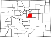
Deckers, Colorado — Town — Location within the state of Colorado
 Deckers, Colorado
Coordinates: 39°15′19″N 105°13′38″W / 39.25528°N 105.22722°WCoordinates: 39°15′19″N 105°13′38″W / 39.25528°N 105.22722°W Country  United States
State  State of Colorado
County Douglas Government - Type unincorporated town Area - 0 sq mi (0 km2) Elevation[1] 6,398 ft (1,950 m) Time zone MST (UTC-7) - Summer (DST) MDT (UTC-6) ZIP code[2] Sedalia CO 80135 Deckers is an unincorporated town along the South Platte River in Douglas County, Colorado, United States. The U.S. Post Office at Sedalia (ZIP Code 80135) now serves Deckers postal addresses.[2]
Contents
Geography
Deckers is located at 39°15′19″N 105°13′38″W / 39.25528°N 105.22722°W (39.255386,-105.227222).
Camp
National Ramah announced in March 2006 that it plans to open a Camp Ramah in the Rockies. A 360-acre (1.5 km2) camp site has been purchased in Deckers.
See also
- Denver-Aurora Metropolitan Statistical Area
- Denver-Aurora-Boulder Combined Statistical Area
- Front Range Urban Corridor
- List of cities and towns in Colorado
References
- ^ "US Board on Geographic Names". United States Geological Survey. 2007-10-25. http://geonames.usgs.gov. Retrieved 2008-01-31.
- ^ a b "ZIP Code Lookup" (JavaScript/HTML). United States Postal Service. January 3, 2007. http://zip4.usps.com/zip4/citytown.jsp. Retrieved January 3, 2007.
Municipalities and communities of Douglas County, Colorado County seat: Castle Rock Cities Aurora‡ | Castle Pines North | Littleton‡ | Lone Tree
Towns CDPs Acres Green | Castle Pines | Franktown | Grand View Estates | Highlands Ranch | Louviers | Meridian | Perry Park | Roxborough Park | Sedalia | Stonegate | The Pinery | Westcreek
Unincorporated
communitiesAcequia | Castle Pines Village | Cottonwood | Dakan | Deckers | Greenland | Perry Park Ranch
Footnotes ‡This populated place also has portions in an adjacent county or counties
Categories:- Populated places in Douglas County, Colorado
- Unincorporated communities in Colorado
- Denver metropolitan area


Wikimedia Foundation. 2010.